Zoning Ordinance
Table of Contents
ARTICLE II: INTERPRETATION AND DEFINITIONS
SECTION 200 – RULES FOR WORDS AND PHRASES
ARTICLE III: ESTABLISHMENT OF ZONING DISTRICTS; PROVISION FOR OFFICIAL ZONING MAP
SECTION 300 – ZONING DISTRICTS
SECTION 301 – OFFICIAL ZONING MAP
SECTION 302 – REPLACEMENT OF OFFICIAL ZONING MAP
SECTION 303 – RULES FOR INTERPRETATION OF DISTRICT BOUNDARIES
ARTICLE IV: GENERAL REGULATIONS
SECTION 400 – APPLICATION OF REGULATIONS
SECTION 401 – DIMENSIONAL CONTROLS
SECTION 402 – PUBLIC/QUASI-PUBLIC FACILITIES AND UTILITIES
SECTION 404 – BUFFER YARDS/SCREENING STANDARDS
SECTION 405 – HOME OCCUPATIONS
SECTION 406 – PORTABLE STORAGE UNITS
SECTION 407 – STREET ACCESS REQUIRED
SECTION 408 – COMPLIANCE WITH THE STATE DEPARTMENT OF HEALTH
SECTION 409 – PLOT PLAN REQUIRED
SECTION 411 – MAINTENANCE AND LIABILITY OF DEDICATED OPEN SPACE, SCREENS AND BUFFERS
SECTION 412 – SKIRTING REQUIREMENTS FOR CERTAIN STRUCTURES
SECTION 413 – MATERIALS AND GROWTH CONSTITUTING PUBLIC HEALTH AND/OR SAFETY HAZARD PROHIBITED
SECTION 414 – PARKING AND STORAGE OF VEHICLES REQUIRING LICENSES
SECTION 415 – LARGE TRUCKS PROHIBITED IN PLATTED RESIDENTIAL ZONED SUBDIVISIONS
SECTION 416 – LIVESTOCK AND WILD ANIMALS PROHIBITED IN PLATTED RESIDENTIAL SUBDIVISIONS
SECTION 417 – FOOD TRUCKS AND MOBILE VENDORS
ARTICLE V: AGRICULTURAL GENERAL DISTRICT (A-1)
SECTION 500 – PURPOSE OF THIS DISTRICT
SECTION 501 – LAND USES PERMITTED OUTRIGHT
SECTION 502 – CONDITIONAL USES AND STRUCTURES AS PROVIDED IN SECTION 2905
SECTION 503 – DIMENSIONAL REQUIREMENTS
SECTION 504 – SITE PLAN REQUIRED
ARTICLE VI: AGRICULTURAL INTENSIVE DISTRICT (A-2)
SECTION 600 – PURPOSE OF THIS DISTRICT
SECTION 601 – LAND USES PERMITTED
SECTION 602 – CONDITIONAL USES AND STRUCTURES AS PROVIDED IN SECTION 2905
SECTION 603 – DIMENSIONAL REQUIREMENTS
SECTION 604 – SITE PLAN REQUIRED
ARTICLE VII: RESIDENTIAL ESTATE DISTRICT (RE-1)
SECTION 700 – PURPOSE OF THIS DISTRICT
SECTION 701 – LAND USES PERMITTED
SECTION 702 – CONDITIONAL USES AND STRUCTURES AS PROVIDED IN SECTION 2905
SECTION 703 – DIMENSIONAL REQUIREMENTS
SECTION 704 – SITE PLAN REQUIRED
ARTICLE VIII: RESIDENTIAL ESTATE MIXED DISTRICT (RE-1A)
SECTION 800 – PURPOSE OF THIS DISTRICT
SECTION 801 – LAND USES PERMITTED
SECTION 802 – CONDITIONAL USES AND STRUCTURES AS PROVIDED IN SECTION 2905
SECTION 803 – DIMENSIONAL REQUIREMENTS
SECTION 804 – SITE PLAN REQUIRED
ARTICLE IX: SINGLE-FAMILY RESIDENTIAL DISTRICT (R-1)
SECTION 900 – PURPOSE OF THIS DISTRICT
SECTION 901 – LAND USES PERMITTED
SECTION 902 – CONDITIONAL USES AND STRUCTURES AS PROVIDED IN SECTION 2905
SECTION 903 – DIMENSIONAL REQUIREMENTS
SECTION 904 – SITE PLAN REQUIRED
ARTICLE X: MODERATE DENSITY RESIDENTIAL DISTRICT (R-1B)
SECTION 1000 – PURPOSE OF THIS DISTRICT
SECTION 1001 – LAND USES PERMITTED
SECTION 1002 – CONDITIONAL USES AND STRUCTURES AS PROVIDED IN SECTION 2905
SECTION 1003 – DIMENSIONAL REQUIREMENTS
SECTION 1004 – SITE PLAN REQUIRED
ARTICLE XI: MEDIUM DENSITY RESIDENTIAL DISTRICT (R-1C)
SECTION 1100 – PURPOSE OF THIS DISTRICT
SECTION 1101 – LAND USES PERMITTED
SECTION 1102 – CONDITIONAL USES AND STRUCTURES AS PROVIDED IN SECTION 2905
SECTION 1103 – DIMENSIONAL REQUIREMENTS
SECTION 1104 – SITE PLAN REQUIRED
ARTICLE XII: PATIO HOME RESIDENTIAL DISTRICT (R-ID)
SECTION 1200 – PURPOSE OF THIS DISTRICT
SECTION 1201 – LAND USES PERMITTED
SECTION 1202 – CONDITIONAL USES AND STRUCTURES AS PROVIDED IN SECTION 2905
SECTION 1203 – DIMENSIONAL REQUIREMENTS
SECTION 1204 – REQUIRED OPEN SPACE RESERVATION
SECTION 1205 – SITE PLAN REQUIRED
ARTICLE XIII: TOWNHOUSE RESIDENTIAL DISTRICT (R-3)
SECTION 1300 – PURPOSE OF THIS DISTRICT
SECTION 1301 – LAND USES PERMITTED
SECTION 1302 – CONDITIONAL USES AND STRUCTURES AS PROVIDED IN SECTION 2905
SECTION 1303 – DIMENSIONAL REQUIREMENTS
SECTION 1304 – REQUIRED OPEN SPACE RESERVATION
SECTION 1305 – PROPERTY LINES BETWEEN ADJOINING TOWNHOUSES
SECTION 1306 – UNDERGROUND UTILITY CONNECTIONS FOR TOWNHOUSES
SECTION 1307 – SITE PLAN REQUIRED
ARTICLE XIV: HIGH DENSITY RESIDENTIAL DISTRICT (R-4)
SECTION 1400 – PURPOSE OF THIS DISTRICT
SECTION 1401 – LAND USES PERMITTED
SECTION 1402 – CONDITIONAL USES AND STRUCTURES AS PROVIDED IN SECTION 2905
SECTION 1403 – DIMENSIONAL REQUIREMENTS
SECTION 1404 – REQUIRED OPEN SPACE RESERVATION
SECTION 1405 – SITE PLAN REQUIRED
ARTICLE XV: PLANNED UNIT DEVELOPMENT DISTRICT (PUD)
SECTION 1500 – PURPOSE OF THIS DISTRICT
SECTION 1501 – PLANNED UNIT DEVELOPMENTS SHALL BE SUPERIMPOSED DISTRICTS
SECTION 1503 – LAND USES PERMITTED
SECTION 1504 – CONDITIONAL USES AND STRUCTURES AS PROVIDED IN SECTION 2905
SECTION 1505 – DIMENSIONAL REQUIREMENTS
SECTION 1507 – REQUIRED COMMON OPEN SPACE RESERVATION
SECTION 1508 – AS BUILT LETTER
SECTION 1509 – SITE PLAN REQUIRED
ARTICLE XVI: MANUFACTURED HOME PARK DISTRICT (MHP)
SECTION 1600 – PURPOSE OF THIS DISTRICT
SECTION 1601 – LAND USES PERMITTED
SECTION 1602 – CONDITIONAL USES AND STRUCTURES AS PROVIDED IN SECTION 2905
SECTION 1603 – BUILDING PERMIT REQUIRED
SECTION 1604 – DIMENSIONAL REQUIREMENTS
SECTION 1605 – OFF-STREET PARKING REQUIREMENTS
SECTION 1606 – PRIVATE STREETS WITHIN MANUFACTURED HOME PARKS
SECTION 1607 – UTILITIES AND DRAINAGE
SECTION 1608 – FREEDOM FROM FLOODING AND PONDING
SECTION 1609 – REFUSE COLLECTION FACILITIES
SECTION 1610 – EXTERIOR LIGHTING
SECTION 1611 – SITE PLAN REQUIRED
ARTICLE XVII: MANUFACTURED HOME SUBDIVISION DISTRICT (MHS)
SECTION 1700 – PURPOSE OF THIS DISTRICT
SECTION 1701 – LAND USES PERMITTED
SECTION 1702 – CONDITIONAL USES AND STRUCTURES AS PROVIDED IN SECTION 2905
SECTION 1703 – DIMENSIONAL REQUIREMENTS
SECTION 1704 – COMPLIANCE WITH RANKIN COUNTY SUBDIVISION REGULATIONS
SECTION 1705 – SITE PLAN REQUIRED
ARTICLE XVIII: RESIDENTIAL MIXED DISTRICT(R-MX)
SECTION 1800 – PURPOSE OF THIS DISTRICT
SECTION 1801 – LAND USES PERMITTED
SECTION 1802 – CONDITIONAL USES AND STRUCTURES AS PROVIDED UNDER SECTION 2905
SECTION 1803 – DIMENSIONAL REQUIREMENTS
SECTION 1804 – SITE PLAN REQUIRED
ARTICLE XIX: RESTRICTED BUSINESS/PROFESSIONAL DISTRICT (P-1)
SECTION 1900 – PURPOSE OF THIS DISTRICT
SECTION 1901 – LAND USES PERMITTED
SECTION 1902 – CONDITIONAL USES AND STRUCTURES AS PROVIDED UNDER SECTION 2905
SECTION 1903 – DIMENSIONAL REQUIREMENTS
SECTION 1904 – SITE PLAN REQUIRED
ARTICLE XX: GENERAL COMMERCIAL DISTRICT (C-2)
SECTION 2000 – PURPOSE OF THIS DISTRICT
SECTION 2001 – LAND USES PERMITTED
SECTION 2002 – CONDITIONAL USES AND STRUCTURES AS PROVIDED UNDER SECTION 2905
SECTION 2003 – DIMENSIONAL REQUIREMENTS
SECTION 2004 – SITE PLAN REQUIRED
ARTICLE XXI: MAJOR THOROUGHFARES COMMERCIAL DISTRICT (C-3)
SECTION 2100 – PURPOSE OF THIS DISTRICT
SECTION 2101 – LAND USES PERMITTED
SECTION 2102 – CONDITIONAL USES AND STRUCTURES AS PROVIDED UNDER SECTION 2905
SECTION 2103 – DIMENSIONAL REQUIREMENTS
SECTION 2104 – SITE PLAN REQUIRED
ARTICLE XXII: ADULT ENTERTAINMENT COMMERCIAL DISTRICT (C-4)
SECTION 2200 – PURPOSE OF THIS DISTRICT
SECTION 2201 – LAND USES PERMITTED
SECTION 2202 – CONDITIONAL USES AND STRUCTURES AS PROVIDED UNDER SECTION 2905
SECTION 2203 – DIMENSIONAL REQUIREMENTS
SECTION 2204 – SITE PLAN REQUIRED
ARTICLE XXIII: LIMITED INDUSTRIAL DISTRICT (I-1)
SECTION 2300 – PURPOSE OF THIS DISTRICT
SECTION 2301 – LAND USES PERMITTED
SECTION 2302 – CONDITIONAL USES AND STRUCTURES AS PROVIDED IN SECTION 2905
SECTION 2303 – DIMENSIONAL REQUIREMENTS
SECTION 2304 – SITE PLAN REQUIRED
ARTICLE XXIV: HEAVY INDUSTRIAL DISTRICT (I-2)
SECTION 2400 – PURPOSE OF THIS DISTRICT
SECTION 2401 – LAND USES PERMITTED
SECTION 2402 – CONDITIONAL USES AND STRUCTURES AS PROVIDED IN SECTION 2905
SECTION 2403 – DIMENSIONAL REQUIREMENTS
SECTION 2404 – SITE PLAN REQUIRED
ARTICLE XXV: SPECIAL USE DISTRICT (S-1)
SECTION 2500 – PURPOSE OF THIS DISTRICT
SECTION 2501 – LAND USES PERMITTED
SECTION 2502 – CONDITIONAL USES AND STRUCTURES AS PROVIDED IN SECTION 2905
SECTION 2503 – DIMENSIONAL REQUIREMENTS
SECTION 2504 – SITE PLAN REQUIRED
ARTICLE XXVI: RESERVOIR COMMUNITY DISTRICT (RCD)
SECTION 2600 – PURPOSE OF THIS DISTRICT
SECTION 2601 – RESERVOIR COMMUNITY DISTRICT IS A SUPERIMPOSED DISTRICT
SECTION 2602 – LAND USES PERMITTED
SECTION 2603 – CONDITIONAL USES AND STRUCTURES AS PROVIDED IN SECTION 2905
SECTION 2604 – LAND USES NOT PERMITTED
SECTION 2605 – DIMENSIONAL REQUIREMENTS
SECTION 2606 – SITE PLAN REQUIRED
SECTION 2608 – ACCESSORY STRUCTURES
SECTION 2609 – SIGN REGULATIONS FOR RESERVOIR COMMUNITY DISTRICT
ARTICLE XXVII: OFF-STREET PARKING REQUIREMENTS
SECTION 2700 – PURPOSE OF THIS ARTICLE
SECTION 2701 – OFF-STREET PARKING
ARTICLE XXVIII: NONCONFORMITIES
SECTION 2800 – PURPOSE OF THIS ARTICLE
SECTION 2801 – TYPES OF NONCONFORMITIES
SECTION 2802 – REGULATIONS CONCERNING NONCONFORMING UNDEVELOPED LOTS OF RECORD
SECTION 2803 – REGULATIONS CONCERNING NONCONFORMING STRUCTURES
ARTICLE XXIX: ADMINISTRATION AND ENFORCEMENT
SECTION 2900 – PURPOSE OF THIS ARTICLE
SECTION 2902 – CREATION AND DUTIES OF THE RANKIN COUNTY PLANNING COMMISSION
SECTION 2904 – DIMENSIONAL VARIANCES
SECTION 2905 – CONDITIONAL USES (SPECIAL EXCEPTIONS)
SECTION 2906 – AMENDMENTS TO THE ZONING ORDINANCE TEXT OR THE OFFICIAL ZONING MAP (REZONING)
SECTION 2907 – SITE PLAN REVIEW: PURPOSES AND WHEN REQUIRED
SECTION 2908 – SITE PLAN REVIEW PROCEDURES
SECTION 2909 – SPECIFICATIONS FOR ALL REQUIRED SITE PLANS
SECTION 2910 – CRITERIA FOR SITE PLAN REVIEW
SECTION 2911 – PUBLIC HEARING NOTICES AND PROCEDURES
SECTION 2914 – ORDINANCE ENFORCEMENT
ARTICLE XXX: MISCELLANEOUS PROVISIONS
SECTION 3000 – PURPOSE OF THIS ARTICLE
SECTION 3001 – OMISSION CLAUSE
SECTION 3002 – SEPARABILITY AND VALIDITY CLAUSE
SECTION 3003 – REPEAL OF CONFLICTING ORDINANCES OR PARTS THEREOF
SECTION 3004 – REFERENCES INCLUDE SUBSEQUENT REVISIONS, AMENDMENTS OR ENACTMENTS
SECTION 3005 – FAILURE TO ENFORCE ORDINANCE
SECTION 3006 – EFFECTIVE DATE OF ORDINANCE
SECTION 3007 – ADOPTION CLAUSE
ZONING REGULATIONS
RANKIN COUNTY, MISSISSIPPI
AN ORDINANCE ESTABLISHING COMPREHENSIVE ZONING REGULATIONS FOR RANKIN COUNTY, MISSISSIPPI, AND PROVIDING FOR THE ADMINISTRATION, ENFORCEMENT, AND AMENDMENT THEREOF, AND FOR THE REPEAL OF ALL ORDINANCES IN CONFLICT THEREWITH.
PREAMBLE
WHEREAS, the Statutes of the State of Mississippi, Section 17-1-1 to 17-1-27, inclusive, of the Mississippi Code of 1972, annotated, as amended, empower the Rankin County, Mississippi, to enact a Zoning Ordinance and to provide for its administration, enforcement and amendment; and
WHEREAS, Section 17-1-9 of the Mississippi Code of 1972, annotated, as amended, states that "zoning regulations shall be made in accordance with a comprehensive plan, and designed to lessen congestion in the streets; to secure safety from fire, panic, and other dangers; to provide adequate light and air; to prevent the overcrowding of land; to avoid undue concentration of population; to facilitate the adequate provision of transportation, water, sewerage, schools, parks, and other public requirements; and
WHEREAS, Section 17-1-1 of the Mississippi Code of 1972, annotated, as amended, defines the term "comprehensive plan" as "a statement of public policy for the physical development of the entire municipality or county adopted by resolution of the governing body, consisting of the following elements at a minimum: (1) goals and objectives for the long-range (twenty to twenty-five years) development of the county or municipality---; (2) a land use plan---; (3) a transportation plan---; and (4) a community facilities plan---"; and
WHEREAS, Section 17-1-11 of the Mississippi Code of 1972, annotated, as amended, states that "the governing authority of each municipality and county may provide for the preparation, adoption, amendment, extension and carrying out of a comprehensive plan---;" and
WHEREAS, the Board of Supervisors have adopted by resolution a Comprehensive Plan, following public hearings relative to same; and
WHEREAS, the Board of Supervisors have divided the County into districts and adopted regulations pertaining to such districts, and have given reasonable consideration among other things, to the character of the districts and their particular suitability for particular uses, with a view to conserving the value of property and encouraging the most appropriate use of land throughout the County; and
WHEREAS, the Board of Supervisors have given due public notice of a hearing relating to said zoning ordinance and map and have held a public hearing in accordance with the requirements of Section 17-1-15 of the Mississippi Code of 1972, annotated, as amended:
NOW, THEREFORE, BE IT ORDAINED BY THE BOARD OF SUPERVISORS OF RANKIN COUNTY, MISSISSIPPI, THAT THIS ORDINANCE SHALL GOVERN THE USE OF ALL LAND WITHIN THE BOUNDARIES OF RANKIN COUNTY, MISSISSIPPI.
ARTICLE I: TITLE AND PURPOSE
SECTION 100 – TITLE
The Ordinance shall be known as the "Zoning Ordinance of Rankin County, Mississippi,” and may be so cited, and further reference elsewhere as "Zoning Ordinance,” and herein as "the Ordinance" or "this Ordinance" shall imply the same wording and meaning as the full title.
SECTION 101 – PURPOSE
The purpose of this Ordinance is to preserve and promote the public health, safety, morals, and general welfare of the citizens of Rankin County and of the public generally through the regulation of: the location, height, number of stories, size of buildings and other structures; the density and distribution of population, size of yards and other open spaces; and the use of buildings, structures, and land for commercial, industrial, residential and other purposes.
ARTICLE II: INTERPRETATION AND DEFINITIONS
SECTION 200 – RULES FOR WORDS AND PHRASES
For the purpose of this Ordinance, words used in the present tense include the future tense; words in the singular number include the plural number, and words in the plural number include the singular number; the word "shall" is mandatory and not directory; the word "may" is permissive; the word "used" includes "designed" and "intended or arranged to be used or occupied"; and the word "person" includes a firm, association, organization, partnership, trust, foundation, company or corporation as well as an individual.
SECTION 201 – DEFINITIONS
For the purpose of this Ordinance certain words, phrases and terms used herein shall be interpreted as stated in this Article II. Any word, phrase or term not defined herein shall be defined by the Zoning Administrator, the interpretation based on its common and ordinary usage.
Accessory Structure or Use: Any detached structure or use which is subordinate or incidental to the main building or dominant use of the lot or premises, excluding driveways, sidewalks and fences.
Adult Entertainment Use (or Activity or Establishment): An adult arcade, adult bookstore, adult cabaret, adult motel, adult motion picture theater, or similar establishment which regularly features or depicts behavior which is characterized by the exposure of "specified anatomical areas" (as defined by this Ordinance), or where any employee, operator or owner exposes his/her "specified anatomical area" for viewing of patrons. Such adult entertainment uses may further be defined as follows:
Adult Arcade: An establishment where, for any form of consideration, one or more motion picture projectors, or similar machines, for viewing by five or fewer persons each, are used to show films, motion pictures, video cassettes, slides or other photographic reproductions which are characterized by emphasis upon the depiction or description of "specified sexual activities" (as defined by this Ordinance) or "specified anatomical areas."
Adult Bookstore: An establishment which has as a substantial portion of its stock-in-trade and offers for sale for any form of consideration any one or more of the following:
A. Books, magazines, periodicals, or other printed matter, or photographs, films motion pictures, video cassettes, slide or other visual representations which are characterized by an emphasis upon the depiction or description of "specified sexual activities" or "specified anatomical areas," or
B. instruments, devices or paraphernalia which are designed for use in connection with "specified sexual activities."
Adult Cabaret: A nightclub, bar, restaurant, theater, or similar establishment which regularly features live performances which are characterized by the exposure of "specified anatomical areas" or by "specified sexual activities,” or films, motion pictures, video cassettes, slides or other photographic reproductions which are characterized by an emphasis upon the depiction or description of "specified anatomical areas" or by "specified sexual activities."
Adult Motel: A motel or similar establishment which includes the word "adult" in any name it uses or otherwise advertises the presentation of adult material, offering public accommodations for any form of consideration which provides patrons with closed-circuit television transmissions, films, motion pictures, video cassettes, slides or other photographic reproductions which are characterized by an emphasis upon the depiction or description of "specified anatomical areas" or by "specified sexual activities."
Adult Motion Picture Theater: An establishment where, for any form of consideration, films, motion pictures, video cassettes, slides or other photographic reproductions are shown, and in which a substantial portion of the total presentation time is devoted to the showing of material which is characterized by an emphasis upon the depiction or description of "specified anatomical areas" or by "specified sexual activities."
Alley: A public or private right-of-way primarily designed to serve as a secondary access to the sides or rear of those properties for which principal frontage is on some other street; alleys are intended to provide access for refuse collection, loading/unloading and for fire protection.
Animal Control Ordinance: When used in this Ordinance, this term shall refer to the Animal Control Ordinance of Rankin County.
Apartment: A dwelling unit located in a multiple family structure for occupancy by one family only, either rented or leased to the occupants. See also "Condominium."
Arterial Street/Highway: See "Street."
Assisted Living: Assisted refers to a type of physical assistance rather than monetary assistance. In assisted living facilities, residents live independently in apartment or condominium style accommodation, and may be assisted by the provision of meals, housekeeping, security and social programs. Additional planned care, such as bathing, dressing and assistance with medication may also be provided.
Bar: A structure or part or a structure used primarily for the sale or dispensing of liquor by the drink.
Basement: A story wholly or partially underground. For the purpose of height regulation, a basement shall be counted as a story when more than one-half of its height is above the average grade level.
Bed and Breakfast Service: A small hotel or, more often, a private home that offers overnight accommodations and breakfast for paying guests either on a daily or weekly rental basis.
Boarding House (Lodging or Rooming House): A building other than a hotel or motel, where, for compensation and by prearrangement for definite periods, meals and/or lodging are provided for three or more but not exceeding twelve persons (other than family members) on a weekly or monthly basis.
Buffer Area: An area so planned which acts as a buffer or separation area between two or more uses or structures not compatible due to design, function, use or operation.
Buildable Area, Maximum: That portion of a lot remaining after required yards have been provided.
Buffer Yard/Strip: A strip of land, identified on a site plan or by the zoning ordinance, which acts to separate two or more incompatible uses and/or districts. Normally, the area is landscaped and kept in open space use.
Building: Any structure having a roof supported by columns or walls and intended for shelter, housing or enclosure of persons, animals, equipment, goods, or materials. The term "building" shall be construed as if followed by the words "or part thereof."
Building, Fully-Enclosed: A building having walls on all sides.
Building Height: The vertical distance measured from the average elevation of the finished grade within twenty feet of the structure to the highest point of the roof.
Building Permit: A permit issued by the County official designated by the Rankin County Board of Supervisors authorizing the construction, placement or structural alteration of a specific building on a specific lot.
Building, Portable: Any building that is portable in nature, without any wheels, and built on a chassis or frame designed and constructed to be used without a permanent
foundation. Building permits are required prior to the placement of such buildings on any lot.
Building Setback Line: See “Setback Line.”
Building, Structural Alteration of: Any change or rearrangement in the supporting members, including bearing walls, beams, columns, or girders of a building.
Canopy: A roof-like structure which is not enclosed by walls on all sides and may or may not project from a building.
Carport: A roofed structure providing space for the parking or storage of motor vehicles and enclosed on not more than three sides.
Cemetery: Property used for the interring of the dead. ALL cemeteries are considered public/quasi-public facilities, subject to the regulations of Section 402.
Certificate of Occupancy: A certificate issued by the County official designated by the Rankin County Board of Supervisors to ensure that new or altered buildings or structures are in conformance with the provisions of the Zoning Ordinance and any other Federal, State, and County laws (such as water, sewer, and other necessary infrastructure is in place) and to have a record on the point.
Change of Use: An alteration or change from a previous use of land, buildings, or structures to another use of land, buildings, or structures.
Child Care Facility: A place which provides shelter and personal care for six (6) or more children who are not related to the operator, whether such place be organized or operated for profit or not.
County: Rankin County, Mississippi.
Clinic: A facility for diagnosis and treatment of medical, chiropractic, dental or psychological outpatients, provided that patients are not kept overnight, and which may be used by one or a group of medical or dental practitioners. These shall be regulated as a commercial use.
Collector Street: See “Street.”
Compatibility: The characteristics of different uses or activities that permit them to be located near each other in harmony and without conflict. Some elements affecting compatibility include: residential density; pedestrian or vehicular traffic generated; volume of goods handled; and such environmental effects such as noise, vibration, glare, air pollution, or radiation.
Comprehensive Plan: In accordance with Section 17-1-1 of the Mississippi Code of 1972, Annotated, As Amended, "comprehensive plan" shall be defined as "a statement of public policy for the physical development of the entire municipality---adopted by resolution of the governing body, consisting of the following elements at a minimum: (I)Goals and Objectives---; (ii) a Land Use Plan---; (iii) a Transportation Plan---; and (iv) a Community Facilities Plan---." Community Facilities Plan: One of the elements of a Comprehensive Plan. Section 17-1-1 of the Mississippi Code of 1972, Annotated, As Amended, defines the term as follows: "a community facilities plan (serves as) a basis for a capital improvements program including, but not limited to, the following: housing; schools; parks and recreation; public buildings and facilities; and utilities and drainage."
Conditional Use (Special Exception): A land use which would not generally be appropriate in a particular zoning district, but which, with certain restrictions or conditions, would in the judgement of the Board of Supervisors promote the public health, safety, morals, or general welfare of the County and would not adversely affect adjacent properties. A permit (building permit or change of use permit) granted by the Board of Supervisors for the initiation of a conditional use (with the necessary restrictions included) will not change the zoning of the property involved and will allow such use to continue as long as the specific use granted by the conditional use remains the same. Also referred to as a “Special Exception.”
Condominium: Real property consisting of an undivided interest in common of a portion of a parcel of real property, plus a separate interest in space in a residential, office, commercial or other land use. (From: Mississippi Code of 1972, Annotated, Section 89-9-7.) See also “Apartment.”
Conforming Use: Any lawful use of a building or lot which complies with the provisions of this Zoning Ordinance.
Convalescent Home (Rest Home or Nursing Home): Those health facilities where persons are housed and furnished with meals and continuing nursing services for a fee.
Convenience Store: A store of not more than 3,000 square feet of retail sales area, not counting storage, which deals in grocery items of a convenience nature. Also, commonly referred to as a “drive-in” grocery store.
Country Club: A land area and buildings containing recreational facilities, clubhouse and the usual accessory uses, open only to members and their guests for a membership fee. Country clubs are regulated as public/quasi-public facilities and are subject to the provisions of Section 402 of this Ordinance.
Coverage: That part of a lot covered by buildings.
Density: The intensity of land use and also the maximum intensity of use of a minimum lot or land area physically possible observing all yard, height, and lot or land area coverage provisions of this Zoning Ordinance, exclusive of any publicly dedicated rights-of-way.
Developer: The legal or beneficial owner or owners of a lot or of any land included in a proposed development including the holder of an option or contract to purchase, or other persons having enforceable proprietary interests in such land.
Development: The division of a parcel of land into two or more parcels; the construction, reconstruction, conversion, structural alteration, relocation or enlargement of any structure; any mining, excavation, landfill or land disturbance, and any use or extension of the use of land.
Development Plan: A drawing or set of drawings depicting the ultimate layout and proposed land uses for a large tract of land, usually involving varying lot sizes and/or different proposed land uses. A development plan of a subdivision may be considered the "sketch plat" if a subdivision is to be constructed in phases. A development plan is sometimes referred to as a "master plan"; however, since the Comprehensive Plan for the County may also be called a "Master Plan,” the term Master Plan is not used in this Ordinance.
Dimensional Variance: See “Variance.”
Disabled Persons: Individuals suffering from a permanent condition resulting from a mental or physical impairment that leaves such persons unable to perform a "major life functions." (From: Accommodating Disabilities: Business Management Guide, published by the Commerce Clearing House, Inc., 1992; this publication deals with the requirements of the Americans with Disabilities Act).
District: Any section or sections of Rankin County for which regulations governing the use of land and the use, density, bulk, height, and coverage of buildings and other structures are established by this Ordinance.
Drainage Channel: A watercourse with a definite bed and banks which conduct and confine the normal continuous and intermittent flow of water.
Driveway: A private roadway providing access for vehicles to a parking space, garage, dwelling or other structure.
Drive-In Restaurant: See "Restaurant, Drive-In":
Dwelling: Any building, or portion thereof, or manufactured home, which is designed and used for human habitation.
Dwelling, Single-Family: A site-built residential building designed for occupancy by one family. For the purposes of this ordinance, single-family dwelling does not refer to Mobile, Manufactured, Modular, Panelized or Pre-Cut homes.
Dwelling, Two-Family (Duplex): A residential building designed to be occupied by two families living independently of each other.
Dwelling, Multiple-Family: Any residential building or portion thereof which is occupied by three or more families living independently of each other. The term "multiple-family dwelling" shall be understood to include apartment houses or "complexes" and condominiums.
Dwelling, Patio (or House or Home): A single-family dwelling unit that is constructed nearer the lot line on ONE SIDE (but not directly on either lot line) of a lot than the other side.
Dwelling Unit: A room or group of rooms occupied or intended to be occupied as separate living quarters.
Dwelling, Zero Lot Line: A detached single-family dwelling on a separate lot with open space setbacks on three sides. In order to be considered a true "zero lot line dwelling" the dwelling must rest directly against a lot line on one side of the lot; otherwise, it shall be considered a patio home.
Easement: A grant by the property owner to the public, a corporation or persons for the use of a strip of land for specific purposes.
Employee (Staff): Any person who is regularly on the premises of a business or industrial establishment for productive use on a part-time or full-time basis. For the purposes of this Ordinance the maximum number of employees on the premises of an establishment at one time shall constitute the number of employees.
Facilities and Utilities, Public/Quasi-Public: Any building, structure, system, use, or combination of uses, which is customarily and ordinarily provided by either public or private agencies, groups, societies, corporations, or organizations, whose purpose is the provision of necessary and desirable goods and/or services for the general public health, safety, and welfare. Such uses shall include, but not be limited to:
A. Churches and other religious institutions.
B. Schools, including all private, public or parochial schools, excluding institutions of higher learning which shall be zoned "Special Use" districts only.
C. All governmental buildings (including municipal buildings and buildings erected by County, State or Federal governments) and major governmental facilities, such as water pumping stations, sewage treatment plants, sanitary landfills and the like. (Note: Public recreation and open space facilities are a land use permitted outright in any district, and such facilities are not subject to the regulations of Section 402 as conditional uses.)
D. All hospitals, whether public or private.
E. Convalescent homes, nursing homes or assisted living facilities.
F. Civic organization buildings and major facilities.
G. Buildings and facilities erected by charitable organizations (e.g., American Red Cross, Salvation Army, etc.); (Note: When such facilities are erected as emergency measures, they shall be exempt from the Special Exception provisions of this Ordinance, including site plan review and public hearing requirements).
H. Country clubs and other major recreational facilities constructed by private groups.
I. All cemeteries.
J. Major facilities associated with privately-owned utilities (electrical, natural gas, telephone) including but not limited to electrical substations, telephone communications centers, microwave towers, cellular telephone antennas, natural gas pumping facilities and similar significant uses.
Factory-Built Dwelling or Home: A dwelling unit manufactured in part or whole within a factory to include Manufactured Home, Mobile Home, Modular Home, Panelized Home, and Pre-Cut Home.
Family: One person living alone, or two or more persons living together as a single, housekeeping unit, whether related to each other legally or not, as distinguished from a group occupying a boarding house, lodging house, hotel, motel, dormitory or similar dwelling for group use. A family shall be deemed to include domestic servants employed by said family when these servants are on-premise residents.
Feedlot: A confined area or structure, pen, or corral, used to fatten livestock prior to final shipment.
Floor Area: The sum of the gross horizontal area of all floors of a building, excluding all porches, balconies, garages or carports, measured from the interior face of the exterior walls, or from the centerline of a wall separating two buildings.
Food Truck (or Mobile Vendor): A vehicle equipped with facilities for cooking and selling food or from which food is sold. The vehicle shall remain on wheels at all times.
Frontage: Property on one side of a street measured along the line of the street, or in the case of a corner lot or "through lot,” the property on each street measured along the lines of both streets.
Funeral Home (or Mortuary): A building used for the preparation of deceased human bodies for burial or cremation and the display of the deceased and ceremonies connected therewith before burial or cremation.
Future Land Use Plan: See "Land Use Plan."
Garage (Private): The term "garage" shall mean a private garage, which is a fully enclosed portion of a main building or a fully enclosed accessory building (i.e., detached from the main building) and used primarily for the storage of privately owned automobiles.
Garage, Mechanical (Repair Shop): A building or portion thereof, other than a private or storage garage, designed or used for servicing, repairing, equipping of motor-driven vehicles and the storage of such vehicles; also include selling, renting, or leasing of motor-driven vehicles in conjunction with repair work.
Garage, Storage: A building or portion thereof, other than a private garage, used exclusively for the parking or storage of motor-driven vehicles, with no other facilities provided except facilities for washing. Also referred to as a parking garage.
Gasoline Service Station: Any area of land, including the structures thereon, that is primarily used for the retail sale of gasoline, diesel fuel, oil or automobile accessories and incidental services including facilities for lubricating, washing (either automatic or by hand) and cleaning, or otherwise servicing automobiles and light trucks. This term does not include the painting or major repair of vehicles.
Goals and Objectives: One of the elements of a Comprehensive Plan. Section 17-1-1 (c)(ii) of the Mississippi Code of 1972, Annotated, As Amended, defines the term as follows: "goals and objectives (are a list of policies, adopted by the governing authorities) for the long-range (twenty to twenty-five years) development of the county or municipality. Required goals and objectives shall address, at a minimum, residential, commercial, and industrial development; parks, open space and recreation, street or road improvements; public schools and community facilities."
Grade or Grade Level: The finished elevation of land after completion of site preparations for construction.
Grandfather Clause: The section of the zoning ordinance which allows existing non-conforming uses, buildings, structures, and lots to continue until they are removed by any means.
Homeowners Association: A non-profit organization (corporate or otherwise) operating under recorded land agreements through which each property owner is automatically subject to a charge for a proportionate share of expenses for maintaining common open space, other activities and facilities.
Home Occupation: Any activity carried out for gain by a resident conducted as an accessory use in the resident's dwelling unit or an accessory building.
Hospital: A public or quasi-public institution where sick or injured persons are given medical care and in the course of same are housed overnight, fed and provided nursing and related services.
Hospital, Veterinary: A facility where sick or injured animals are given medical or surgical care and, in the course of same, may be housed overnight, fed, and provided related services.
Hotel or Motel: A building or buildings where lodging, food and various personal services are provided for more than twenty (20) persons, who are usually but not always transients, for compensation. Hotels and motels shall be considered a commercial use.
Independent Living: Residents of independent living facilities are totally independent. However, limited services may be provided on an as-needed basis.
Industry, Heavy: Those industrial uses which are not fully enclosed and/or which generate substantial amounts of noise, vibration, odors or possess other objectionable characteristics.
Industry, Limited (Light): Those industrial uses including manufacturing activities conducted wholly within completely enclosed buildings (except for the temporary storage within adequately screened or buffered areas of articles, materials, or other matter to be processed, assembled or otherwise changed) and other industrial-related activities which do not generate objectionable odors, smoke, fumes, vibration, or excessive noise.
Industry, "Wet-Type": Those heavy industrial uses which require the discharge of by-products or processed waste water through the sewer system. Such industrial uses shall be permitted as a conditional use only in the Heavy Industrial Districts (I-2).
Inn (or "Bed and Breakfast Inn"): An establishment operated in conjunction with a private dwelling where lodging is available or lodging and food are available for up to twenty (20) persons for compensation.
Internal Building Space: The required minimum space between principal or accessory buildings on the same lot.
Junk Yards: A place where waste and discharged or salvaged materials are bought, sold, exchanged, baled, packed, disassembled or handled, including auto wrecking yards, used lumber yards, house dismantling yards, and places or yards for storage of salvaged house wrecking and structural steel materials and equipment; but excluding places where such uses are conducted entirely within a completely enclosed building, and not including pawn shops and establishments for the sale, purchase, or storage of used furniture and household equipment, used cars in operable condition or salvaged materials incidental to manufacturing operations.
Kennel: A facility other than a residence, where four or more dogs or cats, or a combination thereof, are boarded, whether by the owners of the animals or other persons, with or without compensation. A kennel shall be considered a commercial use.
Landscaping: The addition of lawns, trees, plants, and other natural or decorative features to land, including lakes and watercourses. Landscape treatment can include walks or patios.
Land Use Plan: One of the elements of a Comprehensive Plan, usually developed concurrently with the Transportation/ Thoroughfares Plan. Section 17-1-1 (c)(ii) of the Mississippi Code of 1972, Annotated, As Amended, defines the term as follows: "a land use plan designates in map or policy form the proposed general distribution and extent of the use of land for residences, commerce, industry, recreation, and open space, public/ quasi-public facilities and lands. Background information shall be provided concerning the specific meaning of land use categories depicted in the plan in terms of the following: residential densities; intensity of commercial uses; industrial and public/quasi-public uses; and any other information needed to adequately define the meaning of such land use codes. Projections of population and economic growth for the area encompassed by the plan may be the basis for quantitative recommendations for each land use category."
Liquor Store: A store that sells alcoholic beverages for consumption elsewhere.
Livestock: Those animals which are normally considered as farm animals, such as cattle, goats, sheep, horses, ponies, mules, emus, llamas, pigs (any animal in the swine family), chickens, turkeys, ducks, geese, and other similar animals
Loft-Style Apartment: A dwelling unit located in an upper story of a business or commercial building such as an upper story converted to quarters for living.
Lot: A parcel of land at least sufficient size to meet the minimum requirements for use, coverage, and area and to provide such yards and other open spaces as specified in the Zoning Ordinance of Rankin County, Mississippi.
Lot Area: The total area of a lot included within the boundary lines of a lot.
Lot, Corner: A lot abutting upon two or more streets at their intersections.
Lot Depth: The average horizontal distance between the front and rear lot line.
Lot, Double Frontage: A lot which runs through a block from street to street (i.e., has frontage on more than one street); double frontage lots are also called "through lots."
Lot Frontage: The front of a lot shall be construed to be that dimension of a lot abutting on a street. For the purpose of determining yard requirements on corner lots or double frontage lots, all sides of such lots abutting on public streets shall be considered lot frontage, and yards shall be provided as indicated in this Ordinance.
Lot, Interior: A lot other than a corner lot.
Lot Lines: The lines bounding a lot as such parcel of land is defined herein.
Lot Line, Front: In the case of an interior lot, the property boundary line separating said lot from the street. In the case of a corner lot or double frontage lot, the line separating said lot from the street on which the building will face, as determined from the application for a building permit.
Lot Line, Rear: The property boundary line opposite and most distant from the front lot line. In the case of a pointed or irregular lot, it shall be an imaginary line parallel to and farthest from the front lot line.
Lot of Record: A lot which is a part of a subdivision, the map of which is recorded in the office of the Chancery Clerk of Rankin County, Mississippi, or a lot described by metes and bounds, the description of which has been recorded in said office.
Lot Width: The distance from side of lot to side of lot measured at the front minimum building setback line.
Manufacturing Use: A facility at which goods are made from secondary materials (previously prepared or refined materials) or raw materials (unrefined materials) through the use of machinery and labor and often employing assembly line techniques. In the case of "light" manufacturing uses, most goods are produced from secondary materials, except for processing, packaging, or canning of food products, and little or no water is used in the manufacturing process. In the case of “heavy" manufacturing, goods are often produced from raw materials and may involve the use of large amounts of water.
Manufactured Home: These are homes built entirely in a factory under a Federal building code administered by the U.S. Department of Housing and Urban Development (HUD). The Federal Manufactured Home Construction and Safety Standards (commonly known as the HUD Code) went into effect June 15, 1976. Manufactured homes may be single or multi-section and are transported to a site and installed. Such homes shall be considered Factory Built Homes for the purpose of this Ordinance.
Manufactured Home Park: An area, tract, site or plot of land of at least ten acres, which has been planned, improved and meets the requirements of this Ordinance, and in which spaces are provided on a rental basis or lease basis only for owner-occupied homes or in which both the space and the manufactured home are offered to the public on a rental or lease basis only.
Manufactured Home Space or Lot: A plot of ground within a manufactured home park designed for and designated as (on an approved site plan) the location of one manufactured home, and which has water, sewer and electricity at the space.
Manufactured Home Stand or "Pad": The paved runners or paved parking area in each manufactured home space upon which the manufactured home is placed, together with the paved patio and paved off-street vehicular parking area.
Mobile Home: This is the term used for factory-built homes produced prior to June 15, 1976. Such homes shall be considered Factory Built Homes for the purpose of this Ordinance.
Modular Homes: These factory-built homes are built to the state, local or regional code where the home will be located. Modules are transported to the site and installed. Such homes shall be considered Factory Built Homes for the purpose of this Ordinance.
Mortuary: See "Funeral Home."
Motel: See "Hotel."
Multiple Family Dwelling: See "Dwelling, Multiple Family."
Multi Level Care: Multi level care refers to many types of care. These can be intermediate, extended, dementia, Alzheimer, palliative, recovery and respite. This is often referred to as Residential Care.
Nonconformities: Any land, lot, building, structure or parts thereof existing prior to the enactment of this Ordinance, which subsequent to the enactment of this Ordinance or amendment thereto, does not conform with the use regulations and/or dimensional regulations of the district in which it is situated, and/or does not comply with any other requirements herein. (See Section 2801 of this Ordinance for definitions of the various types of nonconformities, including (1) nonconforming undeveloped lots of record," (2) nonconforming structures, and (3) nonconforming uses).
Nursery, Child Care: See "Child Care Facility."
Nursery, Horticultural: Commercial uses in which flowers and plants are stored and/or cultivated for retail sale and related products are offered for retail sale.
Nursing Homes: See "Convalescent Home."
Open Space or "Common Open Space": A parcel or parcels of land not occupied by dwellings or residential structures, accessory structures and yards, which may consist of jogging trails, tennis courts, a golf course, swimming pool, associated recreational buildings and the like, and which is permanently maintained in a suitable state for the shared enjoyment by the owners and/or occupants of individual dwelling units or residential structures within a particular development (such as a conventional residential subdivision, an apartment complex, a manufactured home park or a Planned Unit Development).
Office: A room, group of rooms or building in which commercial activities primarily involving the provision of services rather than the sale of commodities are conducted.
Office Park: A development on a tract of land, either subdivided or on a single large lot, containing a number of separate office buildings, supporting uses and open space designed, planned, constructed and managed on an integrated and coordinated basis.
Panelized Homes: These are factory-built homes in which panels - a whole wall with windows, doors, wiring and outside siding - are transported to the site and assembled. The homes must meet state or local building codes where they are sited. Such homes shall be considered Factory Built Homes for the purpose of this Ordinance.
Parking Space: For the purposes of this Ordinance, the term "parking space" shall refer only to parking places not located on a public street. Each parking space shall be sufficient in size to store one full-size automobile, or 200 square feet in area for each such space, exclusive of the necessary maneuvering space providing access to each parking space, unless otherwise approved as part of the site plan review Process.
Patio House or Patio Home: See "dwelling, patio (or house or home).”
Planned Unit Development (PUD): An area of a minimum contiguous size, as specified by this Ordinance, to be planned and developed as a single entity containing one or more residential clusters and in which land not used for residential structures or yards but required by the basic zoning of the site shall be reserved collectively in contiguous units accessible to all building sites in the development as open space for the purpose of providing recreational facilities and pedestrian circulation. Two- family or multiple family dwellings, commercial development or public/quasi-public facilities or utilities may only be permitted in a Planned Unit Development if a Development Plan is submitted and appropriate rezoning (or a Conditional Use for public/quasi-public uses) is approved by the Board of Supervisors.
Planning/Zoning Commission: The duly appointed Planning/Zoning Commission of Rankin County, Mississippi.
Planting Screen: Densely planted vegetation used to visually shield or obscure abutting or nearby structures or uses from other uses or structures.
Plat: A map, plan or layout of a subdivision.
Plot Plan: A drawing indicating the location and layout of a proposed building or structure as outlined by the Building Code.
Portable Building: See "Building, Portable.”
Pre-Cut Homes: This is the name for factory-built housing in which building materials are factory-cut to design specifications, transported to the site and assembled. Pre-cut homes include kit, metal, log and dome homes. These homes must meet local, state or regional building codes. Such homes shall be considered Factory Built Homes for the purpose of this Ordinance.
Principal Structure or Use: The main building(s) or dominant use(s) of a lot.
Property Line: The legal boundary line separating buildings or tracts in different ownership.
Public/Quasi-Public Facilities and Utilities: See "Facilities and Utilities, Public/Quasi-Public.”
Recreational Vehicle (RV): See "Transient Trailer" or "Travel Trailer.”
Residential Care: Residential Care refers to both Multi Level Care and/or Professional Nursing Care (24 hour care).
Rest Home: See "Convalescent Home.”
Restaurant: A commercial establishment where food and beverages are prepared, served and consumed primarily within the principal building, but not including "drive-in restaurants" as defined herein. Restaurants may offer some "carry-out" services where food and beverages are consumed off the premises. This definition is not intended to exclude restaurants which provide food and beverages to customers at "drive-through windows,” where customers in motor vehicles merely pick up food and beverages at such windows and consume same usually off the premises.
Restaurant, Drive-In: A commercial establishment where food and beverages are prepared and where all or a significant portion of the consumption takes place outside of the building, often in a motor vehicles parked for "curb-service" (with two-way speakers) on the site.
Schools: The term "school" as used in this Ordinance shall include public, private, and parochial institutions of learning, including trade or industrial schools" (i.e., those schools offering training to students in skills required for the practice of trades and industry), but excluding Institutions of Higher Learning (colleges and universities), which shall be zoned as “Special Use” Districts only.
Screening: The method by which a view of one site from another adjacent site is shielded, concealed, or hidden. Screening techniques include fences, walls, hedges, berms or other features. Sometimes used in conjunction with a buffer yard.
Service Station: See "Gasoline Service Station.”
Setback: The area between the street right-of-way line and the building setback line.
Setback Line or Building Setback Line: A line delineating the minimum allowable distance between the street right-of-way and the front of a structure within which no building or other structure shall be placed. The minimum distance is prescribed by this Ordinance. The building setback line is parallel to or concentric with the street right-of-way line.
Shopping Center: A group, consisting of three or more commercial establishments, planned, developed and managed as a unit, with adequate off-street parking facilities provided on the property and related in its location, size, and type of stores to the trade area or neighborhood which the unit serves.
Side Street: A street bordering the side of a lot and intersecting the street on which a structure on the lot faces, as determined by the Zoning Administrator; in the case of buildings (as opposed to other types of "structures"), the street which the building faces shall be determined by the principal entrance to the building.
Site Plan: A drawing indicating the location of existing and proposed buildings or other structures, and, where required by this Ordinance, landscaping and planting screens and points of access/egress and driveways on a single lot. A "site plan" differs from a "subdivision plat" in that a subdivision plat reflects certain required information for two or more lots.
Site Plan Review: The process specified under Sections 2907 through 2910 of this Ordinance in which site plans for certain proposed developments and/or site plans (when required by the Zoning Administrator in coordination with other County officials) accompanying applications for dimensional variance, conditional use, and rezoning are reviewed by County officials, the Planning/Zoning Commission and the Board of Supervisors for conformance with this Ordinance and other applicable laws and codes, and to determine what other special restrictions (if any) need to be applied if the site plan and application are approved by the Board of Supervisors.
Specialty Shop: A store that specializes in a particular line of merchandise, such as baked goods, candy, clothing, hardware, clothing, antiques, bicycles, etc.
Special Exception: See "Conditional Use.”
Specified Anatomical Areas: Less than completely and opaquely covered human genitals, pubic region, buttocks, anus or less than 50% of the female breast below a point immediately above the areolae; or human male genitals in a discernibly turgid state even if completely and opaquely covered.
Specified Sexual Activity: Human genitals in a state of sexual stimulation or arousal; acts of human masturbation, sexual intercourse, or sodomy; fondling or other erotic touching of human genitals, pubic regions, buttocks or female breasts; flagellation or torture in the context of a sexual relationship; masochism, erotic or sexually oriented torture, beating or the infliction of physical pain; erotic touching, fondling or other such contact with an animal by a human being; or human excretion, urination, menstruation, vaginal or anal irrigation as part of or in connection with any of the activities set forth in this section.
Spot Zoning: The improper zoning or rezoning of a lot or parcel of land to benefit an owner for a use incompatible with surrounding uses. While such spot zoning may not be illegal per se, it is generally regarded as an improper practice.
Start of Construction: This is the first placement or construction of a structure such as the paving of a slab, placement of footings or land preparation such as excavation, filling, and pad work. Clearing and grubbing of land is not considered to be the start of construction.
Story: That portion of a building included between the surface of any floor and the surface of the next floor above it, or if there be no floor above it, then the space between the floor and the ceiling next above it. For the purposes of height measurement, a basement shall be counted as a story when more than one-half of its height is above the average grade elevation, or when the basement is used for commercial activities (See "Basement").
Street: A publicly-owned thoroughfare which affords the principal means of access to abutting property; such thoroughfares are dedicated by a property owner for public use, accepted by the responsible political entity in which the street is located and is so dedicated, and recorded in the Office of the Rankin County Chancery Clerk.
Street Right-of-Way Line: The legal property boundary line delineating the street right-of-way and the abutting property.
Strip Development: Commercial development, usually one store deep, that fronts on a major street.
Structure: Anything constructed or erected, the use of which requires a fixed location on the ground, or attached to something having a fixed location on the ground. Among other things, structures include buildings, manufactured homes, walls, fences, and billboards, but shall not include "Transient Trailers (Travel Trailers)" as defined herein. The term structure shall be construed as if followed by the words "or part thereof.” The term "structure" is not intended to include driveways, patios, parking lots, or utilities (i.e., utility lines running to a structure).
Structural Alteration of a Building: See "Building, Structural Alteration of.”
Subdivider: Any person, firm, partnership, corporation or other entity acting as a unit, who, having an interest in land, causes it, directly or indirectly, to be divided into a subdivision.
Subdivision: The division or re-division of land into two (2) or more lots, tracts, sites or parcels for the purpose of transfer of ownership, or for development, whether immediate or in the future, by means of an appropriately recorded legal instrument.
Subdivision, Major: All subdivisions not classified as minor subdivisions, including but not limited to subdivisions of five (5) or more lots, or any size subdivision requiring any new street or extension or the creation of any public or quasi-public improvements.
Subdivision, Minor: All subdivisions of four (4) or fewer lots fronting at a minimum of 60% of required lot width on an existing street, not involving any new street or road, or the extension or the creation of any public or quasi-public improvements, and not adversely affecting the remainder of the parcel or adjoining property, and not in conflict with any provision or portion of the Comprehensive Plan, Zoning Ordinance, or Subdivision Regulations.
Subsidized Care: Subsidized and funded are interchangeable terms. This usually refers to beds, rooms, or suites that are partially paid for by the government.
Substantial Improvement: Any repair, reconstruction or improvement of a structure, the cost of which equals or exceeds fifty (50) percent of the actual cash value of the structure either; (1) before the improvement is started, or (2) if the structure has been damaged and is being restored, before the damage occurred. Substantial improvement is started when the first alterations of any structural part of the building commences.
Surface Mining or Mining: Extraction of minerals, including dirt, soil, sand, gravel or other materials from the ground or water or from waste or stock piles or from pits or banks or natural occurrences by methods including but not limited to, strip, drift, open pit, contour or auger mining, dredging, placering, quarrying and leaching and activities related thereto, which will alter the surface.
Theater, Motion Picture: A building or part of a building devoted primarily to the showing of motion pictures on a paid admission basis.
Theater, Drive-In: An open lot or part thereof, with its appurtenant facilities devoted primarily to the showing of moving pictures or theatrical productions, on a paid admission basis, to patrons seated in automobiles or on outdoor seats.
Through Lot: See "Lot, Double Frontage.”
Thoroughfares Plan: The primary component of the "Transportation Plan,” which is one of the elements of a Comprehensive Plan, usually developed concurrently with another element, the "Land Use Plan.”
Townhouse: A single-family dwelling constructed in a series or group of attached units with property lines separating each unit. (From: Standard Building Code).
Townhouse Subdivision: A subdivision in which the developer proposes to partition land into individual lots and construct townhouses wherein both the dwellings and the lots will be individually owned by the residents.
Trailer: Archaic term sometimes applied to manufactured homes.
Transient Trailer (Travel Trailer): A portable or mobile living unit used for temporary human occupancy away from the place or residence of the occupants. No such equipment shall be used for living, sleeping, or housekeeping purposes for more than 180 days within a period of one year when parked in a residentially zoned area or in any other location not approved for such use. All such equipment shall be fully licensed and ready for highway use. For the purposes of this Ordinance, such transient trailers shall be considered a vehicle and not a structure. The term transient trailer" or "travel trailer" shall include pick-up truck campers,” "motor homes,” "camping trailers" and "recreational vehicles.”
Transient Trailer Park: A commercial operation where space and service accommodations for transient trailers are provided for a fee on an overnight or daily basis.
Transportation Plan: One of the elements of a Comprehensive Plan. Section 17-1-1 (c)(ii) of the Mississippi Code of 1972, Annotated, As Amended.
Truck Stop: Any area of land, including the structures thereon, that is used for the servicing of heavy trucks (i.e., tractor-trailer combinations designed for transporting large cargoes), and which may offer food and beverages in addition to lodging.
Undeveloped Lot: A vacant lot or parcel of land.
Use: The specific purpose for which land or a building is designed, arranged, intended, or for which it is or may be occupied or maintained. The term "permitted use" shall not be deemed to include any nonconforming use.
Use, Accessory: See "Accessory Use.”
Utility: See "Facilities and Utilities, Public/Quasi-Public.”
Vape (or Electronic Cigarette) Shop: A shop selling electronic cigarettes, personal vaporizers, electronic nicotine delivery systems or other vaping products.
Variance: A relaxation of the terms of the Zoning Ordinance where such variance will not be contrary to the public interest and where, owing to conditions peculiar to the property and not the result of the actions of the applicant, a literal enforcement of the Ordinance would result in unnecessary and undue hardship. However, financial hardship shall not be considered justification for granting a variance. The criteria for issuance of a variance are listed under Section 2904 of this Ordinance. As used in this Ordinance, a variance is authorized only for height, area, and size of structure or size of yards and open spaces. Establishment or expansion of a use not permitted shall not be allowed by variance, nor shall a variance be granted because of the presence of nonconformities in the zoning district or uses in an adjoining district.
Vehicle: Any device for carrying passengers, goods, or equipment, usually moving on wheels. This definition does not include manufactured homes, which are considered structures for the purposes of this Ordinance.
Veterinary Hospital: See "Hospital, Veterinary.”
Wild Animals: Reptiles and any animal which by its nature is wild and untamed including, but not limited to, monkeys, deer, wolves, bear and buffalo.
Yard (or "Minimum Yard" or "Setback"): The required open space between any main building or portion thereof and the adjoining lot lines, which shall remain unoccupied and unobstructed by any portion of a structure, except as otherwise specifically provided herein. In measuring a lot for the purpose of determining the minimum front, side or rear yard, the shortest horizontal distance between the lot line and the nearest vertical structure shall be used.
Yard, Front: The required unoccupied and unobstructed space on the same lot with a main building, extending the full width of the lot, and situated between the front property line and the nearest vertical portion of the main building.
Yard, Rear: The required unoccupied and unobstructed space on the same lot with a main building, situated between the rear property line and the nearest vertical portion of the main building, and extending the full width of the lot.
Yard, Side: The required unoccupied and unobstructed space on the same lot with a main building, situated between the side property line and the nearest vertical portion of the main building.
Zoning Administrator: The official (or officials) charged by the Board of Supervisors with the administration and enforcement of this Zoning Ordinance, or their duly authorized representative.
Zoning Commission: See “Planning/Zoning Commission.”
Zoning District: See "District."
ARTICLE III: ESTABLISHMENT OF ZONING DISTRICTS; PROVISION FOR OFFICIAL ZONING MAP
SECTION 300 – ZONING DISTRICTS
For the purpose of promoting public health, safety, morals, or general welfare, Rankin County, Mississippi, is hereby divided into the following zoning districts:
A-1 Agricultural General District
A-2 Agricultural Intensive District
RE-1 Residential Estate District
RE-1A Residential Estate Mixed District
R-1 Single Family Residential District
R-1B Moderate Density Residential District
R-1C Medium Density Residential District
R-1D Patio Home District
R-3 Townhouse Residential District
R-4 High Density Residential District
PUD Planned Unit Development
MHP Manufactured Home Park District
MHS Manufactured Home Subdivision District
R-MX Residential Mixed District
P-1 Restricted Business/Professional District
C-2 General Commercial District
C-3 Major Thoroughfares Commercial District
C-4 Adult Entertainment District
I-1 Limited Industrial District
I-2 Heavy Industrial District
S-1 Special Use District
RCD Reservoir Community District
SECTION 301 – OFFICIAL ZONING MAP
The aforesaid zoning districts are identified and delineated on a map entitled "Official Zoning Map: Rankin County, Mississippi,” and said map, together with all explanatory matter thereon, is hereby adopted by reference and declared to be a part of this Ordinance.
301.01 Map Certified: The Official Zoning Map shall be identified by the signature of the Board President, attested by the Chancery Clerk, and shall bear the seal of the County under the following words:
"This is to certify that this is the Official Zoning Map of Rankin County, Mississippi, as adopted by the Board of Supervisors on _________ ."
301.02 Location of Official Zoning Map: Regardless of the existence of purported copies of the Official Zoning Map which may from time to time be prepared or printed, the Official Zoning Map bearing the certificate specified under Section 301.01 and located in the Courthouse of Rankin County shall be the final authority as to the zoning status of land and water areas, buildings, and other structures in Rankin County.
301.03 Public Inspection of Map: The Official Zoning Map shall be available for public inspection as provided by law during normal business hours of the County Courthouse of Rankin County.
301.04 Map Amendment: If, in accordance with the provisions of this Ordinance and Statutes of the State of Mississippi, changes are made in the zoning district boundaries or other matters portrayed on the Official Zoning Map, such changes shall be made within thirty (30) days after the amendment has been approved by the Board of Supervisors.
Since the Official Zoning Map is part of this Ordinance, any amendments to the Official Zoning Map shall be accomplished in accordance with state statutes relating to passage of ordinances. Therefore, before the Official Map may be amended, an "Ordinance of Rezoning" shall be drafted and passed by the Board of Supervisors in accordance with state law. An unauthorized change of whatever kind by any person or persons shall be considered a violation of this Ordinance and punishable as provided under Section 2914.
SECTION 302 – REPLACEMENT OF OFFICIAL ZONING MAP
In the event that the Official Zoning Map becomes damaged, destroyed, lost, or difficult to interpret because of the nature or number of changes and additions, the Board of Supervisors may, by ordinance, designate a new Official Zoning Map which shall replace the prior zoning map. The new Official Zoning Map may correct drafting errors or other omissions on the prior Official Zoning Map, but no such correction shall have the effect of amending the original Official Zoning Map or any subsequent amendment thereof. The new Official Zoning Map shall be identified by the signature of the Board President, attested by the Chancery Clerk, and shall bear the seal of the County under the following words:
"This is to certify that this Official Zoning Map replaces the Official Zoning Map adopted as part of the Zoning Ordinance of Rankin County, Mississippi, on ___________." (Last date changed by Ordinance)
SECTION 303 – RULES FOR INTERPRETATION OF DISTRICT BOUNDARIES
Where uncertainty exists as to the boundaries of districts as shown on the Official Zoning Map, the following shall apply:
A. Boundaries indicated as approximately following the center lines of roads, highways, or alleys shall be construed to follow such center lines.
B. Boundaries indicated as approximately following platted lot lines shall be construed as following such lot lines.
C. Boundaries indicated as approximately following County limits shall be construed as following such County limits.
D. Where the boundary of a district follows a railroad right-of-way, such boundary shall be deemed to be located on the right-of-way line to which it is closest.
E. Boundaries indicated as approximately following the center lines of streams, rivers, canals, lakes or other bodies of water shall be construed to follow such center lines.
F. Where physical or cultural features existing on the ground are at variance with those shown on the Official Zoning Map, or in other circumstances not covered by Section 303, the Board of Supervisors shall interpret the district boundaries.
G. Where a district boundary line divides a lot which was in a single ownership at the time of passage or amendment of this Ordinance, the Board of Supervisors may permit, as a conditional use, the extension of the district line into the remaining portion of the lot.
H. Boundaries indicated as parallel to or extensions of features indicated in Section 303, Subsections (A) through (G) above shall be so construed.
ARTICLE IV: GENERAL REGULATIONS
SECTION 400 – APPLICATION OF REGULATIONS
400.01 Compliance Required: No building, structure, or land shall hereafter be used or occupied, and no building or structure or part thereof shall hereafter be erected, constructed, reconstructed, moved or structurally altered except in conformance with all of the regulations specified for the district in which it is located. Furthermore, no person shall use or occupy a building, structure or land within Rankin County for an activity which requires a federal, State of Mississippi and/or County license until said license is obtained from the appropriate authorities.
400.02 Nonconformities Defined: "Nonconformities" shall consist of any land, lot, building, structure, or parts thereof, or the various uses to which those items are or were put, and which lawfully existed prior to the enactment of this Ordinance; but which subsequently do not comply with the provisions of this Ordinance and the requirements of the district wherein located. The regulations pertaining to such nonconformities are established in the district regulations and under Article XXVIII.
400.03 Permitted Uses Constitute Conforming Uses: Any land use which is permitted as a conditional use in a particular district under the terms of this Ordinance shall not be deemed a nonconforming use in such district, but shall without further action be considered a conforming use.
400.04 District Regulations Constitute Minimum Regulations: The regulations established in this Ordinance within each district shall constitute minimum regulations unless otherwise noted.
400.05 Uniformity within Districts: The regulations and provisions established by this Ordinance for each district shall apply uniformly within each district of the same name and shall apply uniformly to each class or type of building, structure, use, or land therein except as otherwise provided.
400.06 Pending Applications for Building Permits: Nothing in this Ordinance shall require any change in the overall layout, plans, construction, size or designated use of any development, building, structure or part thereof for which official approvals and required building permits have been legally granted before the enactment of this Ordinance. Construction shall have been started within six (6) months of the effective date of this Ordinance and completed within a subsequent two year period and not discontinued until completion except for reasons beyond the builder's control. All permits for which start of construction has not begun within six (6) months of the effective date of this Ordinance are hereby revoked and void.
SECTION 401 – DIMENSIONAL CONTROLS
401.01 Reduction of Yards and Lots Below Minimum Requirements Prohibited: No yard or lot of record existing at the time of passage of this Ordinance shall be reduced in dimension or area below the minimum requirements set forth herein. Yards or lots of record created after the effective date of this Ordinance shall meet at least the minimum requirements established by this Ordinance.
401.02 Determination of Setbacks: In measuring a required front yard (i.e., setback), the minimum horizontal distance between the existing right-of-way line and the main structure shall be used.
401.03 Exceptions to Height Regulations: The height regulations contained in the District Regulations of this Ordinance do not apply to spires, belfries, cupolas, antennas, water tanks, ventilation chimneys, masts, towers, or other appurtenances usually required to be placed above the roof level and not intended for human occupancy.
401.04 Visibility at Intersections: On a corner lot in any district, nothing shall be erected, placed, planted, or allowed to grow in such a manner as to materially impede the vision of motor vehicle operators between a height of two and one-half (2 ½) and ten (10) feet above the center line grades of the intersecting streets and within a triangular area bounded by the right-of-way lines for a distance of twenty-five (25) feet from the intersection and a straight line connecting said points twenty-five (25) feet back from the intersection of said right-of-way lines.
SECTION 402 – PUBLIC/QUASI-PUBLIC FACILITIES AND UTILITIES
All public and quasi-public facilities and utilities, as defined under Article II of this Ordinance, may be located in any district in the County, provided:
A. That all applicable requirements of federal, state and county laws shall be met.
B. That all such proposed uses shall be subject to the procedures stated under Section 2905 relative to Conditional Uses (Special Exceptions), except for cellular phone towers/antennas and churches which may be approved through administrative review by the Department of Community Development. The Department of Community Development may defer review and approval to the Planning Commission.
No public or quasi-public facility or utility shall be located in a residential district or other district where such land use would adversely affect the surrounding area.
SECTION 403 – DIMENSIONAL REQUIREMENTS FOR PUBLIC/QUASI-PUBLIC FACILITIES AND UTILITIES IN ALL DISTRICTS
Developers of churches, schools, hospitals, civic organizational buildings, country clubs, and other public/ quasi-public facilities or utilities in any district shall comply with the following dimensional requirements:
403.01 Maximum Building Height: 35 feet, unless greater height is specifically approved by the Board of Supervisors based upon the required site plan review. Radio, water, cellular phone, and other communication towers may exceed 35 foot height restrictions based upon site plan review. Cellular towers/antennas shall be built as high as practical in order to allow other cellular providers the option of co-locating on an existing tower rather than building additional towers/antennas.
403.02 Minimum Lot Area, Lot Width and Yards: Minimum lot areas, lot widths and minimum yards for all public/quasi-public uses shall be based upon the proposed use, subject to approval of a site plan submitted in accordance with Sections 2907 through 2910 of this Ordinance.
SECTION 404 – BUFFER YARDS/SCREENING STANDARDS
404.01 Purpose and Intent: The purpose and intent of the Buffer/Screening Standards is to maintain many of the environmental features and amenities of the County for present and future generations. Adherence to these regulations will improve the appearance and compatibility of land uses and other development within the County through the installation and maintenance of plantings and fencing for screening and aesthetic effects, thereby serving to protect and preserve the appearance, character, value and safety of the total urban area and nearby properties. Attractive, well maintained buffer yards improve the quality of developing neighboring property owners that the adjacent project will remain relatively unobtrusive. It is intended that these provisions shall constitute minimum requirements.
404.02 Purpose of Buffer Yards and Screens: The purpose of a buffer yard is to provide a space or distance between two (2) incompatible uses. The purpose of screening is to provide an effective visual barrier between an unsightly or distracting activity and adjacent properties or public ways to preserve property values and assure compatibility of uses. It is also the purpose of these provisions to prescribe standards for development and maintenance of plantings, fences, and walls, for conservation and protection of property through provision of barriers against traffic, trespass, noise, heat, glare, and dust, and through improvement of the appearance of individual properties, neighborhoods, and the County. These standards shall apply to all landscaping and screening required by other provisions of the zoning regulations.
404.03 General Standards: Buffer yards and screens require Site Plan Review. Such required site plan shall set forth yards and open spaces, screening walls, or fences and other development and protective requirements considered necessary to create a reasonable transition to and protection of the adjacent property. When the developer needs to ask for a variance from these Buffer Yard Regulations, an alternative Design Plan which shall fulfill the intent of this Ordinance must be submitted to the Planning/Zoning Commission, which will, upon review, make a recommendation regarding the submission. Reference: Site Plan Review, Sections 2907-2910. Variances shall not be granted, which are less than the next lowest minimum standard, and only then if the size of the lot is such that a full buffer is not possible. The site plan should show plant succession, drainage patterns, and landscape design in order to determine if the trees/vegetation grow well in this region, and also if they make good visual screens.
404.04 Buffer Yard Standards Relating to Abutting Properties: In the table below, when a district abuts a use indicated, a buffer yard and screen shall be provided by the developing use applying for a building permit as listed in Table I:
TABLE I: Buffer Yard and Screen
Use District |
Abutting Use District |
Minimum in Feet |
|
Width |
Screen Height |
||
RE-1 |
A-1, A-2 |
10 |
6 |
RE-1A |
A-1, A-2 |
10 |
6 |
R-1 |
A-1, A-2, RE-1, RE-1A |
10 |
6 |
R-1B |
A-1, A-2, RE-1, RE-1A, R-1 |
10 |
6 |
R-1C |
A-1, A-2, RE-1, RE-1A, R-1, R-1B |
10 |
6 |
R-1D |
A-1, A-2, RE-1, RE-1A, R-1, R-1B, R-1C |
10 |
6 |
R-3 |
All Agricultural and Residential Districts |
10 |
6 |
R-4 |
All Agricultural and Residential Districts |
10 |
6 |
MHP |
All Agricultural and Residential Districts |
10 |
6 |
MHS |
All Agricultural and Residential Districts |
10 |
6 |
R-MX |
All Agricultural and Residential Districts |
10 |
6 |
P-1 |
All Agricultural and Residential Districts |
20 |
6 |
C-2 |
All Agricultural and Residential Districts and P-1 |
20 |
6 |
C-3 |
All Agricultural and Residential Districts and P-1 |
20 |
6 |
C-4 |
All Agricultural and Residential Districts and P-1 |
30 |
6 |
I-1 |
All Districts except I-2 |
30 |
6 |
I-2 |
All Districts except I-1 |
30 |
6 |
S-1 |
All Agricultural and Residential Districts |
20 |
6 |
404.05 Screening Relative to Abutting Properties: In the table above, when a district abuts a use indicated, screening shall be provided as listed. Screening/fencing may consist of architectural and/or vegetative materials as follows:
A. Architectural Screening: A screen/fence of wood, masonry, stone, concrete or metal may be placed along the property line or along the inner perimeter of the buffer yard so as to provide visual screening at minimum height requirements, at the time of issuance of the Certificate of Occupancy.
B. Vegetative Screening: Trees and other vegetation as needed, shall be planted so as to provide year round visual screening at heights required by Table I. If screening is exclusively vegetation, minimum height requirements shall be met at the time of installation. Earthen berms are considered a part of vegetative screening.
C. Combination of materials: Whenever two or more alternative types of landscaping, fences, or walls are prescribed, they may be provided singly or in any combination.
404.06 Installation: All buffer yards and screening shall be installed in a sound workman like manner and according to accepted good planting procedures with the quality of plant material as herein described. All screening elements of buffer yards shall be installed so as to meet all other applicable ordinances and code requirements. Buffer yards shall require protection from encroachment. (Encroachment is defined as any protrusion of a vehicle outside of a parking space, display area or access way into a buffer yard.)
In the event that plants are destroyed or die of natural causes, such materials shall be replaced within six (6) months. Failure of the owner of the property to maintain the buffer yard in good condition, as set forth above, shall subject him to the penalties as set forth in this Ordinance.
No buffer yard shall be abandoned, paved or otherwise employed for purposes other than screening.
404.07 Visibility at Intersections: See Section 401.04
404.08 Intersection of Driveway and public ROW and/or Private Street: In any district, nothing shall be erected, placed, planted, or allowed to grow in such a manner as to materially impair or block vision between a height of two and one half (2.5) and ten (10) feet above the center line grades of any interesting street/driveways in the area bounded by the street lines/driveway lines of such corner and a line joining points along said street lines fifteen (15) feet from the point of intersection.
404.09 Credit for Existing Plant Material: If the owner can demonstrate that healthy plant material exists on a site prior to its development for the purposes of buffer yard, the application of the above landscape standards may be adjusted by the Planning/Zoning Commission to allow credit for such plant material if such an adjustment is in keeping with and will preserve the intent of this Ordinance.
404.10 Planned District Standards: Fences, walls or vegetative screening shall be provided at the perimeter of planned developments where necessary to screen improvements, glare, uses or other influences having an adverse impact either on the planned development or on adjacent property. Such screening shall be of sufficient height as determined by the topography to improve the impact of such adverse elements on the first floor of any use located either within or adjacent to the planned development.
404.11 Zone Screening Standards: A screen (wall, fence, or landscaping) not less than six (6) feet or more than eight (8) feet in height shall be erected between commercially zoned property and abutting residentially zoned property at the time that any building or structure is erected on the commercial property. The height of the screening shall be the vertical distance measured from the top of the screen to the lowest point to grade within three (3) feet of such screen on the commercially zoned property. The screening shall be constructed on or immediately adjacent to the line dividing the residential and commercial properties. A new screen shall not be required where there is an existing screen, which substantially conforms to this section on the abutting residential property. If the existing screen on abutting residential property is the only screen that conforms to this section, and if is removed, a new screen shall be required.
404.12 Fencing and Landscape Standards: The screen required herein shall consist of a solid fence or wall not less than six (6) nor more than eight (8) feet in height, but shall not extend within fifteen (15) feet of any street or driveway opening onto a street. The screening shall be placed along the property lines or in case of screening along a street, fifteen (15) feet from the street ROW with landscaping (trees, shrubs, grass, and other planting) between the screening and the pavement. A louvered fence shall be considered solid if it blocks direct vision. Planting of a type approved by the Site Plan Review Committee may also be required in addition to, or in lieu of, fencing. Existing screening which complies with minimum standards may be used to meet the requirements of this Ordinance.
404.13 Exceptions to Screen Requirements: The landscaping and screening requirements set forth in other provisions of the zoning regulations shall be subject to the following exceptions:
A. Equivalent Screening of Abutting Lot. Prescribed fences, walls, or dense landscaping need not be provided along a lot line if a building, fence, wall or dense landscaping of at least equivalent height, opacity, and maintenance exists immediately abutting and on the opposite side of said lot line.
B. Height Within Required Minimum Yard. Required fences, walls, or dense landscaping need not be higher than 3 and ½ feet in that portion of any required minimum yard which lies within ten (10) feet of any street line.
C. Lot Too Small to Accommodate a Full Buffer. Property owner may be allowed to substitute a berm or landscaped wall for all or part of the transitional yard requirements. The solid fence or wall should be constructed of materials that are compatible with the principal building.
404.14 Maintenance of Screens: All required planting shall be permanently maintained in good growing condition and, whenever necessary, replaced with new plant materials to ensure continued compliance with applicable landscaping requirements. All required fences and walls shall be permanently maintained in good condition and, whenever necessary, repaired or replaced. The owner shall be responsible for the maintenance of all buffer yards which shall be maintained in good condition so as to present a clean and orderly appearance.
404.15 Permits: Whenever a buffer yard or planting strip is required, it shall be completed prior to issuance of any certificate of occupancy and shall thereafter be maintained with permanent plant materials to provide a screen to abutting properties. They will reduce the possibility of traffic hazards as much as possible. Parking facilities must be designed to require vehicles leaving parking stalls to maneuver on the site to exit onto streets head first.
404.16 Design Standards for Screens, Buffers, Berms, and Walls: The purpose of these standards is to screen parking areas from view, to improve the appearance of parking areas near streets, to break the views of large expanses of pavement, to enhance property values and protect investments, to reduce erosion and storm water run-off problems, to provide shade, to reduce glare, to encourage the saving of large trees and to reduce fumes and dust.
A. Screens and buffers are not required along abutting bridge embankments, railroad tracks, slopes and retaining walls and where permanent landscaping is already provided.
B. Masonry walls, sight proof fencing, or dense landscaping are required between commercial parking lots in side and rear yards abutting parcels that are residentially zoned or contain dwellings. These walls or fencing must be at least six feet high and may be combined with landscaping.
C. Landscaped buffer strips are required between streets and parking lots or other driving surfaces except those serving single family and duplex dwellings. Interior parking islands are encouraged to be planted with trees and other shrubbery. If earthen berms are used, the berms must be used in conjunction with vegetation. Commercial establishments over one story tall must combine architectural screening with vegetative/ landscaping screening.
SECTION 405 – HOME OCCUPATIONS
Home occupations, as defined under Article II of this Ordinance, shall be subject to the following limitations and such conditions as may be determined by the Board of Supervisors for the protection of the health, safety and welfare of the citizens of Rankin County:
405.01 Display and Storage: No storage or display of materials, goods, supplies, or equipment related to the operation of a home occupation shall be visible from the outside of any structure located on the premises.
405.02 Maximum Area: Not more than twenty-five percent (25%) of the floor area of the dwelling shall be used for the conduction of the home occupation. Any accessory building used in connection with the home occupation shall not exceed twenty-five percent (25%) of the floor area of the principal dwelling.
405.03 Traffic and Parking Restrictions: No traffic shall be generated by such home occupations in greater volumes than would normally be expected in a residential neighborhood (as determined by the Zoning Administrator), and any need for parking generated by the conduction of such home occupations shall be met off the street and other than in a required yard. Furthermore, an ample amount of such off-street parking shall be provided as determined by the Zoning Administrator at the time of the application for a building permit or change of use permit.
405.04 Exterior Lighting: There shall be no exterior lighting which would indicate that the dwelling and/or accessory building is being utilized in whole or in part of any purpose other than residential.
405.05 Signs Relating to Home Occupations: The maximum size for all home occupation signs is two (2) square feet. Home occupation signs shall be affixed to the house no more than six (6) feet above floor level and may not be illuminated.
405.06 Other Provisions: No equipment or process shall be used in a home occupation which creates noise, vibration, glare, fumes, or odors detectable to the normal senses outside of the dwelling unit or accessory building in which the occupation is conducted.
405.07 Existing and new home occupations are required to have a privilege license in accordance with state law: A building permit (if construction is necessary in connection with proposed home occupation) or a change of use permit (if no construction is necessary) must be obtained from the Zoning Administrator prior to the initiation of a home occupation.
SECTION 406 – PORTABLE STORAGE UNITS
406.01 Allowed Locations: A Portable Storage Unit (PSU) may be located in any residential zoning district. This section does not regulate the placement or use of a PSU in Residential Estate or in non-residential districts.
406.02 Maximum Size of Allowed PSU and Other Limitations: The total square footage for a PSU on any site in a residential district shall not exceed one hundred thirty (130) square feet in area. Only one (1) PSU is allowed on any site at any given time.
406.03 Maintenance and Security of PSU: The provider of any PSU shall be responsible for ensuring that the PSU is in good condition and free from evidence of deterioration. The owner of any site on which a PSU is placed shall be responsible for keeping the PSU locked when not being loaded or unloaded and must ensure that no hazardous substances are stored or kept within the PSU.
406.04 Setback Requirements: A PSU must be located on the driveway serving the dwelling unit, and must be a minimum of ten (10) feet from the curb of the public street.
406.05 Maximum Duration of Placement of PSU: No PSU shall remain at an allowed location in excess of thirty (30) calendar days.
For a PSU located upon property upon which Rankin County has issued a valid building permit, the maximum duration for placement of such PSU shall be forty-five (45) days, at which time shall be subject to review by the Zoning Administrator. An extension may be granted based on a determination of need in order to complete construction.
In the event of a natural disaster, fire, or other accidental event, then a PSU may remain at a location for the period of time to effect repairs.
406.06 Penalty for Violation: Any violations under this section are subject to the penalties as outlined under Section 2914.
SECTION 407 – STREET ACCESS REQUIRED
Every building or structure hereafter constructed, moved, or structurally altered shall have direct access to a public (dedicated) street or to an approved private street or parking area, and shall be so located as to provide safe access for fire protection.
SECTION 408 – COMPLIANCE WITH THE STATE DEPARTMENT OF HEALTH
Minimum lot size in each zoning district does not constitute approval by the State Health Department for an on-site wastewater disposal system.
SECTION 409 – PLOT PLAN REQUIRED
Every building or structure hereafter constructed, moved, or structurally altered shall have a plot plan submitted to Rankin County Community Development.
SECTION 410 – SURFACE MINING
Extraction of minerals, including dirt, soil, sand and gravel in conjunction with construction activities at a construction site for development of land is not considered to be a surface mining operation which would be subject to the procedures stated under Section 2905 relative to Conditional Uses (Special Exceptions).
SECTION 411 – MAINTENANCE AND LIABILITY OF DEDICATED OPEN SPACE, SCREENS AND BUFFERS
Authority granted by Rankin County for the development of any property shall not be construed as nor constitute an obligation on the part of Rankin County either for maintenance or liability in the operation and use of common open space, screens or buffers located on the property.
SECTION 412 – SKIRTING REQUIREMENTS FOR CERTAIN STRUCTURES
The owner of any manufactured home, modular home or any other dwelling with a crawl space located, re-located or constructed in Rankin County on or after the effective date of this amendment shall be responsible for installing skirting around the base of the structure, thereby completely covering all sides of the structure from the finished grade to the bottom of the structure. Skirting shall be brick, masonry material, lattice material, or a product approved by Rankin County Community Development. In the case of a manufactured home a product which is specifically designed for the purpose of skirting manufactured homes may be used.
SECTION 413 – MATERIALS AND GROWTH CONSTITUTING PUBLIC HEALTH AND/OR SAFETY HAZARD PROHIBITED
No rubbish, salvage materials, junk or hazardous waste materials, including inoperable vehicles and parts and any combustible matter, shall be openly stored, allowed to accumulate or kept in the open and no weeds or other growth shall be allowed to go uncut within any District when the same shall be determined by the appropriate County Official (Director of Community Development, Fire Coordinator, or other authorized County employee) or health official to constitute a menace to the public health and/or safety.
SECTION 414 – PARKING AND STORAGE OF VEHICLES REQUIRING LICENSES
Vehicles that are wrecked, dismantled, partially dismantled, inoperable, abandoned or discarded and are not capable of being legally (that is, if the vehicle does not have a current licensed plate affixed to the vehicle) driven upon the roads, streets or highways of Rankin County shall not be parked or stored on any residentially zoned property whereas it can be seen from public right of way or adjoining property, nor shall such vehicles be parked on public streets or roads.
SECTION 415 – LARGE TRUCKS PROHIBITED IN PLATTED RESIDENTIAL ZONED SUBDIVISIONS
For the purpose of these regulations the term “large truck” is defined to include all trucks with either a cargo box or bed in excess of twenty (20) feet or any motor vehicle greater than one ton. No such trucks shall be permitted to park on streets in platted residential zoned subdivisions, provided however that such trucks may be parked on street for a period not to exceed time the truck is required in the conduct of work on the premises. This requirement is not meant to apply to arterial streets traversing, or adjacent to, residential areas.
SECTION 416 – LIVESTOCK AND WILD ANIMALS PROHIBITED IN PLATTED RESIDENTIAL SUBDIVISIONS
Livestock and wild animals shall not be kept, harbored, raised or permitted to run at large on any property in platted residential subdivisions that are zoned R-1, R-1B, R-1C, R-1D, R-3, R-4, PUD, MHP, MHS or R-MX.
SECTION 417 – FOOD TRUCKS AND MOBILE VENDORS
Food trucks, or mobile vendors, as defined under Article II of this Ordinance, shall be subject to the following limitations and such conditions as may be determined by the Board of Supervisors for the protection of the health, safety and welfare of the citizens of Rankin County:
417.01 Allowed Locations: Any industrial district and shall be subject to the procedures stated under Section 2905 relative to Conditional Uses in commercial districts.
417.02 Applicable Laws: All requirements of federal, state and county laws shall be met, and maintain permits for operation from Mississippi Department of Health.
417.03 Display and Storage: No storage or display of materials, goods, supplies, or equipment related to the operation of a food truck (excluding trash receptacles) shall be visible from the outside of any vehicle involved in the operation.
417.04 Traffic and Parking Restrictions: No traffic shall be generated by such food truck in greater volumes than would normally be expected in a commercial or industrial zone (as determined by the Zoning Administrator), and any need for parking generated by the operation of such food trucks shall be met off the street. Furthermore, an ample amount of such off-street parking shall be provided as determined by the Zoning Administrator at the time of the application for a conditional use permit. A food truck shall not operate on a public roadway or in the public rights-of-way.
417.05 Hours of Operation: Allowed hours of operation shall be limited to 30 minutes prior to sunrise and 30 minutes after sunset, unless the Board of Supervisors determines a different hours of operation as stated in the conditional use permit.
417.06 Signs Relating to Food Trucks: The maximum size for all food truck signs is two (2) square feet. Food truck signs shall be affixed to the vehicle no more than six (6) feet above floor level and may not be illuminated.
417.07 Required Privilege License in Accordance with State and County Law: A privilege license and operation permit must be obtained from the Mississippi Department of Health and the local Zoning Administrator prior to the initiation of a food truck operation. The local permit shall cost an initial fee of $2,500, and the permit shall be renewed annually for a fee of $1,000.
Agriculture General (A-1) Quick Reference Guide
|
|
|||
Example of Land Uses Permitted Outright: |
Dimensional Requirements: |
||
Single Family Dwelling |
Maximum Building Height: |
35 feet |
|
Any Factory Built Home |
Minimum Lot Area: |
One Acre |
|
Accessory Buildings |
Minimum Lot Width: |
None |
|
Recreation/Open Space |
Front Yard: |
None |
|
Forestry |
Side Yard: |
None |
|
Livestock |
Rear Yard: |
None |
|
Select Conditional Use: |
|||
Public/Quasi-Public Facilities |
Buffer and Screening Requirements: |
||
Mining |
Fireworks Sale |
Abutting Use Districts: Not Applicable |
|
P-1 Uses |
C-2 Uses |
Min Width: N/A |
Min Height: N/A |
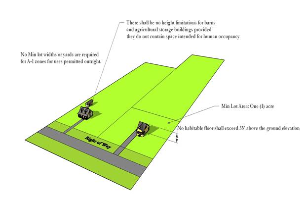
ARTICLE V: AGRICULTURAL GENERAL DISTRICT (A-1)
SECTION 500 – PURPOSE OF THIS DISTRICT
The purposes of this district is to preserve areas for non-intensive agricultural uses and to permit a wide variety of other uses in rural sections of the County. It is the intent of this Ordinance that such districts be located primarily in those areas of Rankin County that are not served by a public or any other approved sewer system. However, each residential, commercial, industrial or public/quasi-public land use in this district shall have an on-site wastewater disposal system approved by the State Health Department and a minimum lot size for each such use of one acre, unless otherwise approved by the Health Department. Development of major or minor subdivisions in this district is not allowed. However, areas zoned A-1 that are located near the more urbanized areas of the county may be considered a transitional area and may be considered for rezoning.
SECTION 501 – LAND USES PERMITTED OUTRIGHT
A. Single-family detached dwelling with only one dwelling per lot.
B. Manufactured homes with only one dwelling per lot.
C. Mobile homes with only one dwelling per lot.
D. Modular homes with only one dwelling per lot.
E. Panelized homes with only one dwelling per lot.
F. Pre-cut homes with only one dwelling per lot.
G. Accessory buildings and structures associated with the use of the land.
H. Breeding, raising, and feeding of grazing livestock including horses, cattle, sheep, goats, mules, etc., except for feedlots as defined by this Ordinance.
I. Forestry and horticultural uses.
J. Public or private recreational or open space facilities, excluding country clubs and the like which shall be regulated as public/quasi-public facilities or utilities subject to the provisions of Section 402 of this Ordinance. All lakes associated with this or any other usage shall comply with Rankin County Subdivision Regulations.
SECTION 502 – CONDITIONAL USES AND STRUCTURES AS PROVIDED IN SECTION 2905
A. P-1 and C-2 Commercial uses.
B. Sale of fireworks.
C. Public or quasi-public facilities and utilities in compliance with Section 402 and other regulations of this Ordinance.
D. Extraction of minerals, including sand and gravel, provided that when “open-pit” operations are conducted, the operator must obtain required permits and approvals from other governmental entities and provide Rankin County Board of Supervisors with written proof of same. Mining operations may be approved through administrative review by the Department of Community Development. The Department of Community Development shall have review and approval authority. The Department of Community Development may defer review and approval to the Planning Commission.
E. Any other use which the Board of Supervisors determine meets the standards outlined under Section 2905.01.
SECTION 503 – DIMENSIONAL REQUIREMENTS
503.01 Maximum Building Height: 35 feet. There shall be no height limitations for barns and agricultural storage buildings provided they do not contain space intended for human occupancy.
503.02 Minimum Lot Area: One (1) acre.
503.03 Minimum Lot Width and Yards: No minimum lot widths or yards are required for A-1 zones for uses permitted outright. However, in accordance with Section 504, all uses permitted as conditional uses shall require Site Plan Review.
SECTION 504 – SITE PLAN REQUIRED
The developer of any conditional use specified in Section 502 in the A-1 district shall submit a site plan to the Board of Supervisors in accordance with Sections 2907 through 2910 of this Ordinance. Dimensional requirements for the proposed conditional use shall be established based upon site plan review.
Agriculture Intensive District (A-2) Quick Reference Guide
|
|
|||
Example of Land Uses Permitted Outright: |
Dimensional Requirements: |
||
Single-Family Dwelling |
Maximum Building Height: |
35 feet |
|
Factory Built Dwelling |
Minimum Lot Area: |
One Acre |
|
Accessory Buildings |
Forestry |
Minimum Lot Width: |
None |
Salvage Yards |
Mining |
Minimum Yards: |
|
Livestock, Swine, Fowl |
Front Yard: |
None |
|
Recreation/Open Space |
Side Yard: |
None |
|
Rear Yard: |
None |
||
Select Conditional Use: |
Buffer and Screening Requirements: |
||
Public/Quasi-Public Facilities |
Abutting Use Districts: Not Applicable |
||
Industrial Uses |
Fireworks Sale |
||
P-1 Uses |
C-2 Uses |
Min Width: N/A |
Min Height: N/A |
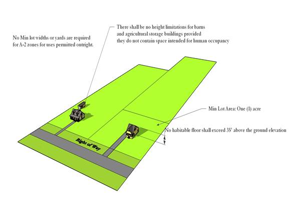
ARTICLE VI: AGRICULTURAL INTENSIVE DISTRICT (A-2)
SECTION 600 – PURPOSE OF THIS DISTRICT
The purposes of these districts to preserve areas for agricultural uses and to permit a wide variety of other uses in rural sections of the County. It is the intent of this Ordinance that such districts be located primarily in those areas of Rankin County that are not served by a public or any other approved sewer system. However, each residential, commercial, industrial or public/quasi-public land use in this district shall have an on-site wastewater disposal system approved by the State Health Department and a minimum lot size for each such use of one acre, unless otherwise approved by the Health Department. Development of major or minor subdivisions in this district is not allowed. However, areas zoned A-2 that are located near the more urbanized areas of the County may be considered a transitional area and may be considered for rezoning.
SECTION 601 – LAND USES PERMITTED
A. All uses allowed in A-1 Agricultural General district.
B. Breeding, raising, and feeding of pigs or hogs, provided that such use meets the requirements of the Rankin County Swine Ordinance.
C. Breeding, raising and feeding of chickens, ducks, turkeys, geese, or other fowl.
D. Extraction of minerals, including sand and gravel, provided that when “open-pit” operations are conducted, the operator must obtain required permits and approvals from other governmental entities and provide Rankin County Board of Supervisors with written proof of same.
E. Feedlots as defined by this Ordinance.
F. Salvage yards as defined by this Ordinance.
SECTION 602 – CONDITIONAL USES AND STRUCTURES AS PROVIDED IN SECTION 2905
A. Industrial uses, including light and heavy uses as defined by this Ordinance.
B. P-1 and C-2 Commercial uses.
C. Sale of fireworks.
D. Public or quasi-public facilities and utilities in compliance with Section 402 and other regulations of this Ordinance.
E. Any other use which the Board of Supervisors determine meets the standards outlined under Section 2905.01.
SECTION 603 – DIMENSIONAL REQUIREMENTS
603.01 Maximum Building Height: 35 feet. There shall be no height limitations for barns and agricultural storage buildings provided they do not contain space intended for human occupancy.
603.02 Minimum Lot Area: One (1) acre.
603.03 Minimum Lot Width and Yards: No minimum lot widths or yards are required for A-2 zones for uses permitted outright. However, in accordance with Section 604, all uses permitted as conditional uses shall require Site Plan Review.
SECTION 604 – SITE PLAN REQUIRED
The developer of any conditional use specified in Section 602 in the A-2 district shall submit a site plan to the Board of Supervisors in accordance with Sections 2907 through 2910 of this Ordinance. Dimensional requirements for the proposed conditional use shall be established based upon site plan review.
Residential Estate District (RE-1) Quick Reference Guide
|
|
|||
Example of Land Uses Permitted Outright: |
Dimensional Requirements: |
||
Single Family, Detached Dwellings |
Maximum Building Height: |
35 feet |
|
Accessory Buildings |
Minimum Lot Area: |
One Acre |
|
Livestock |
Minimum Lot Width: |
100 feet |
|
Recreation/Open Space |
Minimum Yards: |
||
Front Yard: |
30 feet |
||
Side Yard: |
10 feet |
||
Select Conditional Use: |
Rear Yard: |
25 feet |
|
Public/Quasi-Public Facilities |
Buffer and Screening Requirements: |
||
Inns |
Child Care Facility |
Abutting Use Districts: A-1 and A-2 |
|
Office-Type Uses |
Private Conference Centers |
||
Replacement Manufactured Home with Hardship |
Min Width: 10 ft |
Min Height: 6 ft |
|
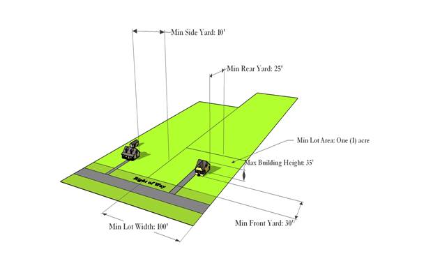
ARTICLE VII: RESIDENTIAL ESTATE DISTRICT (RE-1)
SECTION 700 – PURPOSE OF THIS DISTRICT
The purpose of this district is to provide for large lot, low-density residential development. Residential Estate Districts may be located in areas that do or do not have public or any other approved sewerage.
SECTION 701 – LAND USES PERMITTED
A. Single-family detached dwellings with only one dwelling per lot.
B. Accessory uses and structures associated with the use of land for residential purposes.
C. Public or private recreational or open space facilities, excluding country clubs and the like, which shall be regulated as public/quasi-public facilities and utilities subject to the provisions of Section 402 of this Code. All lakes associated with this or any other usage shall comply with Rankin County Subdivision Regulations.
D. Breeding, raising, and feeding of grazing livestock including horses, cattle, sheep, goats, mules, etc., except for feedlots as defined by this Ordinance.
SECTION 702 – CONDITIONAL USES AND STRUCTURES AS PROVIDED IN SECTION 2905
A. Child care facilities.
B. Inns or “bed and breakfast inns”.
C. Private conference centers.
D. All office-type uses.
E. Use of manufactured home may be allowed in the following hardship, temporary or emergency situations:
1. Cases in which a manufactured home is needed in order for a person or family member to take care of another family member by reason of advanced age, physical disability, medical or mental problems/hardships so long as the condition exist.
2. Cases in which a property owner wishes to build his home on a lot while temporarily living in a manufactured home. A one year limit is required on each such conditional use.
3. Cases in which an owner wishes to rebuild his home damaged by fire or natural disaster while temporarily living in a manufactured home. A one year time limit is required on each such conditional use.
4. Cases where emergency housing is needed. A one year time limit is required on each such conditional use. However, if the applicant is of advanced age and/or is disabled, the Board of Supervisors may extend the time period allowed.
F. Public or quasi-public facilities and utilities in conformance with Section 402 and other regulations of this Code.
G. Extraction of minerals, including sand and gravel, provided that when “open-pit” operations are conducted, the operator must obtain required permits and approvals from other governmental entities and provide Rankin County Board of Supervisors with written proof of the same. Mining operations may be approved through administrative review by the Department of Community Development. The Department of Community Development shall have review and approval authority. The Department of Community Development may defer review and approval to the Planning Commission.
H. Any other use which the Board of Supervisors determines meets the standards outlined under Section 2905.01.
SECTION 703 – DIMENSIONAL REQUIREMENTS
703.01 Maximum Building Height: 35 feet.
703.02 Minimum Lot Area: One (1) acre.
703.03 Minimum Lot Width: 100 feet.
703.04 Minimum Yard:
A. Front yard: 30 feet.
B. Side yards: 10 feet.
C. Rear yard: 25 feet.
SECTION 704 – SITE PLAN REQUIRED
The developer of any subdivision or any conditional use specified in Section 702 in the RE-1 district shall submit a site plan to the Board of Supervisors in accordance with Sections 2907 through 2910 of this Ordinance. Dimensional requirements for the proposed conditional use shall be established based upon site plan review.
Residential Estate Mixed District (RE-1A) Quick Reference Guide
|
|
||
Example of Land Uses Permitted Outright: |
Dimensional Requirements: |
|
Single Family, Detached Dwellings |
Maximum Building Height: |
35 feet |
Accessory Buildings |
Minimum Lot Area: |
One Acre |
Livestock |
Minimum Lot Width: |
100 feet |
Recreation/Open Space |
Minimum Yards: |
|
Front Yard: |
30 feet |
|
Select Conditional Use: |
Side Yard: |
10 feet |
Public/Quasi-Public Facilities |
Rear Yard: |
25 feet |
Inns |
Buffer and Screening Requirements: |
|
Child Care Facility |
Abutting Use Districts: A-1 and A-2 |
|
Office-Type Uses |
||
Private Conference Centers |
Min Width: 10 ft |
Min Height: 6 ft |
Factory Built Home |
||
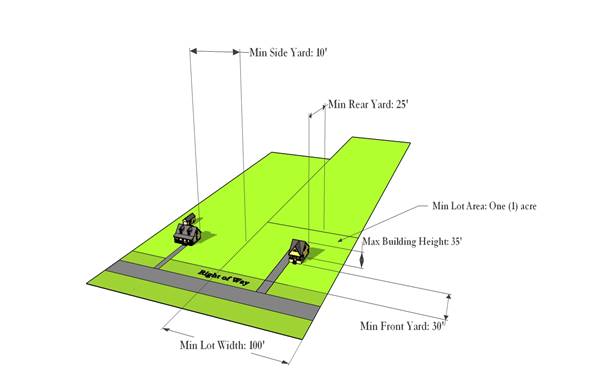
ARTICLE VIII: RESIDENTIAL ESTATE MIXED DISTRICT (RE-1A)
SECTION 800 – PURPOSE OF THIS DISTRICT
The purpose of this district is to provide for large lot, low-density residential development. Residential Estate Districts may be located in areas that do or do not have public or any other approved sewerage. Development of major subdivisions in this district is not allowed; however, the development of minor subdivisions are allowed. Areas zoned RE-1A may be considered a transitional area and may be considered for rezoning.
SECTION 801 – LAND USES PERMITTED
A. Single-family detached dwellings with only one dwelling per lot.
B. Accessory uses and structures associated with the use of land for residential purposes.
C. Public or private recreational or open space facilities, excluding country clubs and the like, which shall be regulated as public/quasi-public facilities and utilities subject to the provisions of Section 402 of this Code. All lakes associated with this or any other usage shall comply with Rankin County Subdivision Regulations.
D. Breeding, raising, and feeding of grazing livestock including horses, cattle, sheep, goats, mules, etc., except feedlots as defined by this Ordinance.
SECTION 802 – CONDITIONAL USES AND STRUCTURES AS PROVIDED IN SECTION 2905
A. Manufactured homes with only one dwelling per lot. This use may be approved through administrative review by the Department of Community Development. The Department of Community Development may defer review and approval to the Planning Commission.
B. Modular Homes with only one dwelling per lot. This use may be approved through administrative review by the Department of Community Development. The Department of Community Development may defer review and approval to the Planning Commission.
C. Panelized homes with only one dwelling per lot. This use may be approved through administrative review by the Department of Community Development. The Department of Community Development may defer review and approval to the Planning Commission.
D. Pre-cut homes with only one dwelling per lot. This use may be approved through administrative review by the Department of Community Development. The Department of Community Development may defer review and approval to the Planning Commission.
E. Child care facilities.
F. Inns or "bed and breakfast inns".
G. Private conference centers.
H. All office-type uses.
I. Public or quasi-public facilities and utilities in conformance with Section 402 and other regulations of this Code.
J. Extraction of minerals, including sand and gravel, provided that when “open-pit” operations are conducted, the operator must obtain required permits and approvals from other governmental entities and provide Rankin County Board of Supervisors with written proof of the same. Mining operations may be approved through administrative review by the Department of Community Development. The Department of Community Development shall have review and approval authority. The Department of Community Development may defer review and approval to the Planning Commission.
K. Any other use which the Board of Supervisors determines meets the standards outlined under Section 2905.01.
SECTION 803 – DIMENSIONAL REQUIREMENTS
803.01 Maximum Building Height: 35 feet.
803.02 Minimum Lot Area: One (1) acre.
803.03 Minimum Lot Width: 100 feet.
803.04 Minimum Yards:
A. Front yard: 30 feet.
B. Side yards: 10 feet.
C. Rear yard: 25 feet.
SECTION 804 – SITE PLAN REQUIRED
The developer of any subdivision or any conditional use specified in Section 802 in the RE-1A district shall submit a site plan to the Board of Supervisors in accordance with Sections 2907 through 2910 of this Ordinance. Dimensional requirements for the proposed conditional use shall be established based upon site plan review.
Single Family Residential District (R-1) Quick Reference Guide
|
|
|||
Example of Land Uses Permitted Outright: |
Dimensional Requirements: |
||
Single Family, Detached Dwellings |
Maximum Building Height: |
35 feet |
|
Accessory Buildings |
Minimum Lot Area: |
11,500 sf |
|
Recreation/Open Space |
Minimum Lot Width: |
80 feet |
|
Minimum Yards: |
|||
Front Yard: |
30 feet |
||
Side Yard: |
8 feet* |
||
Rear Yard: |
25 feet |
||
Select Conditional Use: |
Buffer and Screening Requirements: |
||
Public/Quasi-Public Facilities |
Abutting Use Districts: A-1, A-2, RE-1, RE-1A |
||
Inns |
Mining |
||
Min Width: 10 ft |
Min Height: 6 ft |
||
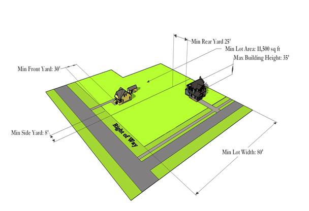
* Except where a larger yard is required to meet buffer yard standards as set forth in Section 404
ARTICLE IX: SINGLE-FAMILY RESIDENTIAL DISTRICT (R-1)
SECTION 900 – PURPOSE OF THIS DISTRICT
The purpose of this district is to provide areas for the development of low density, single-family detached dwellings and related compatible uses in relatively spacious surroundings which provide ample, usable open space for leisure time activities. No new single-family residential subdivisions, major or minor, shall be developed in R-1 districts after the effective date of this Ordinance without public or any other approved sewerage.
SECTION 901 – LAND USES PERMITTED
A. Single-family detached dwellings with only one dwelling per lot.
B. Accessory uses and structures associated with the use of the land for residential purposes.
C. Public or private recreational or open space facilities, excluding country clubs and the like which shall be regulated as public/quasi-public facilities and utilities subject to the provisions of Section 402 of this Ordinance. All lakes associated with this or any other usage shall comply with Rankin County Subdivision Regulations.
SECTION 902 – CONDITIONAL USES AND STRUCTURES AS PROVIDED IN SECTION 2905
A. Inns or "bed and breakfast inns.”
B. Public or quasi-public facilities and utilities in conformance with Section 402 and other regulations of this Ordinance.
C. Extraction of minerals, including sand and gravel, provided that when “open-pit” operations are conducted, the operator must obtain required permits and approvals from other governmental entities and provide Rankin County Board of Supervisors with written proof of the same. Mining operations may be approved through administrative review by the Department of Community Development. The Department of Community Development shall have review and approval authority. The Department of Community Development may defer review and approval to the Planning Commission.
D. Any other use which the Board of Supervisors determine meets the standards outlined under Section 2905.01.
SECTION 903 – DIMENSIONAL REQUIREMENTS
903.01 Maximum Building Height: 35 feet.
903.02 Minimum Lot Area: 11,500 square feet.
903.03 Minimum Lot Width: 80 feet.
903.04 Minimum Yards:
A. Front yard: 30 feet.
B. Side yards: 8 feet, except where a larger side yard is required to meet buffer yard standards as set forth in Section 404.
C. Rear yard: 25 feet.
SECTION 904 – SITE PLAN REQUIRED
The developer of any subdivision or conditional use specified in Section 902 in the R-1 district shall submit a site plan to the Board of Supervisors in accordance with Sections 2907 through 2910 of this Ordinance. Dimensional requirements for the proposed conditional use shall be established based upon site plan review.
Moderate Density Residential District (R-1B) Quick Reference Guide
|
|
|||
Example of Land Uses Permitted Outright: |
Dimensional Requirements: |
||
Single Family, Detached Dwellings |
Maximum Building Height: |
35 feet |
|
Accessory Buildings |
Minimum Lot Area: |
8,500 sf |
|
Recreation/Open Space |
Minimum Lot Width: |
70 feet |
|
Minimum Yards: |
|||
Front Yard: |
25 feet |
||
Side Yard: |
5 feet* |
||
Rear Yard: |
20 feet |
||
Select Conditional Use: |
Buffer and Screening Requirements: |
||
Public/Quasi-Public Facilities |
Abutting Use Districts: A-1, A-2, RE-1, RE-1A, R-1 |
||
Inns |
Mining |
||
Min Width: 10 ft |
Min Height: 6 ft |
||
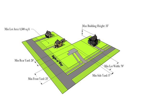
* Except where a larger yard is required to meet buffer yard standards as set forth in Section 404
ARTICLE X: MODERATE DENSITY RESIDENTIAL DISTRICT (R-1B)
SECTION 1000 – PURPOSE OF THIS DISTRICT
The purpose of this district is to provide areas for the development of medium density, single-family detached dwellings and related compatible uses in relatively spacious surroundings which provide ample, usable open space for leisure time activities. No new single-family residential subdivisions, major or minor, shall be developed in R-1B districts after the effective date of this Ordinance without public or any other approved sewerage.
SECTION 1001 – LAND USES PERMITTED
A. Single-family detached dwellings with only one dwelling per lot.
B. Accessory uses and structures associated with the use of the land for residential purposes.
C. Public or private recreational or open space facilities, excluding country clubs and the like which shall be regulated as public/quasi-public facilities and utilities subject to the provisions of Section 402 of this Ordinance. All lakes associated with this or any other usage shall comply with Rankin County Subdivision Regulations.
SECTION 1002 – CONDITIONAL USES AND STRUCTURES AS PROVIDED IN SECTION 2905
A. Inns or "bed and breakfast inns.”
B. Public or quasi-public facilities and utilities in conformance with Section 402 and other regulations of this Ordinance.
C. Extraction of minerals, including sand and gravel, provided that when “open-pit” operations are conducted, the operator must obtain required permits and approvals from other governmental entities and provide Rankin County Board of Supervisors with written proof of the same. Mining operations may be approved through administrative review by the Department of Community Development. The Department of Community Development shall have review and approval authority. The Department of Community Development may defer review and approval to the Planning Commission.
D. Any other use which the Board of Supervisors determine meets the standards outlined under Section 2905.01.
SECTION 1003 – DIMENSIONAL REQUIREMENTS
1003.01 Maximum Building Height: 35 feet.
1003.02 Minimum Lot Area: 8,500 square feet.
1003.03 Minimum Lot Width: 70 feet.
1003.04 Minimum Yards:
A. Front yard: 25 feet.
B. Side yards: 5 feet, except where a larger side yard is required to meet buffer yard standards as set forth in Section 404.
C. Rear yard: 20 feet.
SECTION 1004 – SITE PLAN REQUIRED
The developer of any subdivision or any conditional use specified in Section 1002 in the R-1B district shall submit a site plan to the Board of Supervisors in accordance with Sections 2907 through 2910 of this Ordinance. Dimensional requirements for the proposed conditional use shall be established based upon site plan review.
Medium Density Residential District (R-1C) Quick Reference Guide
|
|
|||
Example of Land Uses Permitted Outright: |
Dimensional Requirements: |
||
Single Family, Detached Dwellings |
Maximum Building Height: |
35 feet |
|
Accessory Buildings |
Minimum Lot Area: |
7,000 sf |
|
Recreation/Open Space |
Minimum Lot Width: |
60 feet |
|
Minimum Yards: |
|||
Front Yard: |
20 feet |
||
Side Yard: |
5 feet* |
||
Rear Yard: |
20 feet |
||
Select Conditional Use: |
Buffer and Screening Requirements: |
||
Public/Quasi-Public Facilities |
Abutting Use Districts: A-1, A-2, RE-1, RE-1A, R-1, R-1B |
||
Modular Homes |
Duplexes |
||
Mining |
Min Width: 10 ft |
Min Height: 6 ft |
|
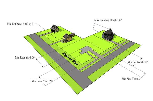
* Except where a larger yard is required to meet buffer yard standards as set forth in Section 404
ARTICLE XI: MEDIUM DENSITY RESIDENTIAL DISTRICT (R-1C)
SECTION 1100 – PURPOSE OF THIS DISTRICT
The purpose of this district is to provide areas for the development of medium density residential uses in relatively spacious surroundings. Any area zoned R-1C Medium Density Residential shall have public or any other approved sewerage.
SECTION 1101 – LAND USES PERMITTED
A. Single-family detached dwellings with only one dwelling per lot.
B. Accessory uses and structures associated with the use of the land for residential purposes.
C. Public or private recreational or open space facilities, excluding country clubs and the like which shall be regulated as public/quasi-public facilities and utilities subject to the provisions of Section 402 of this Code. All lakes associated with this or any other usage shall comply with Rankin County Subdivision Regulations.
SECTION 1102 – CONDITIONAL USES AND STRUCTURES AS PROVIDED IN SECTION 2905
A. Modular homes with only one dwelling per lot.
B. Duplexes.
C. Public or quasi-public facilities and utilities in compliance with Section 402 and other regulations of this Code.
D. Extraction of minerals, including sand and gravel, provided that when “open-pit” operations are conducted, the operator must obtain required permits and approvals from other governmental entities and provide Rankin County Board of Supervisors with written proof of the same. Mining operations may be approved through administrative review by the Department of Community Development. The Department of Community Development shall have review and approval authority. The Department of Community Development may defer review and approval to the Planning Commission
E. Any other use which the Board of Supervisors determine meets the standards outlined under Section 2905.01.
SECTION 1103 – DIMENSIONAL REQUIREMENTS
1103.01 Maximum Building Height: 35 feet.
1103.02 Minimum Lot Area: 7,000 square feet.
1103.03 Minimum Lot Width: 60 feet.
1103.04 Minimum Yards:
A. Front yard: 20 feet.
B. Side yards: 5 feet, except where a larger side yard is required to meet buffer yard standards as set forth in Section 404.
C. Rear yard: 20 feet.
SECTION 1104 – SITE PLAN REQUIRED
The developer of any subdivision or any conditional use specified in Section 1102 in the R-1C district shall submit a site plan to the Board of Supervisors in accordance with Sections 2907 through 2910 of this Ordinance. Dimensional requirements for the proposed conditional use shall be established based upon site plan review.
Patio Home Residential District (R-1D) Quick Reference Guide
|
|
|||
Example of Land Uses Permitted Outright: |
Dimensional Requirements: |
||
Single Family, Detached Dwellings |
Maximum Building Height: |
35 feet |
|
Accessory Buildings |
Minimum Lot Area: |
6,000 sf |
|
Recreation/Open Space |
Minimum Lot Width: |
60 feet |
|
Minimum Yards: |
|||
Front Yard: |
20 feet |
||
Side Yard: |
5 feet*/15 feet between dwelling units |
||
Rear Yard: |
20 feet |
||
Select Conditional Use: |
Buffer and Screening Requirements: |
||
Public/Quasi-Public Facilities |
Abutting Use Districts: A-1, A-2, RE-1, RE-1A, R-1, R-1B, R-1C |
||
Mining |
|||
Min Width: 10 ft |
Min Height: 6 ft |
||
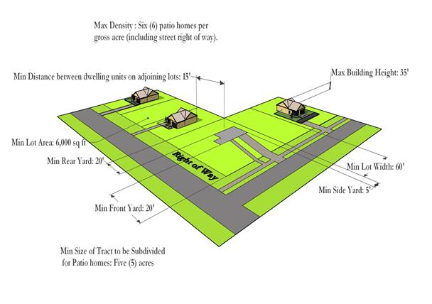
* Except where a larger yard is required to meet buffer yard standards as set forth in Section 404
ARTICLE XII: PATIO HOME RESIDENTIAL DISTRICT (R-ID)
SECTION 1200 – PURPOSE OF THIS DISTRICT
The purpose of this district is to provide areas for the development single-family detached houses on small lots. All areas zoned R-1D shall have public or any other approved sewerage.
SECTION 1201 – LAND USES PERMITTED
A. Single-family detached dwellings with only one dwelling per lot.
B. Accessory uses and structures associated with the use of the land for residential purposes
C. Public or private recreational or open space facilities, excluding country clubs and the like which shall be regulated as public/quasi-public facilities and utilities subject to the provisions of Section 402 of this Zoning Ordinance. All lakes associated with this or any other usage shall comply with Rankin County Subdivision Regulations.
SECTION 1202 – CONDITIONAL USES AND STRUCTURES AS PROVIDED IN SECTION 2905
A. Any use permitted in R-1C, subject to R-1C regulations.
B. Public or quasi-public facilities and utilities in compliance with Section 402 and other regulations of this Zoning Ordinance.
C. Extraction of minerals, including sand and gravel, provided that when “open-pit” operations are conducted, the operator must obtain required permits and approvals from other governmental entities and provide Rankin County Board of Supervisors with written proof of the same. Mining operations may be approved through administrative review by the Department of Community Development. The Department of Community Development shall have review and approval authority. The Department of Community Development may defer review and approval to the Planning Commission.
D. Any other use which the Board of Supervisors determine meets the standards outlined under Section 2905.01.
SECTION 1203 – DIMENSIONAL REQUIREMENTS
1203.01 Maximum Building Height: 35 feet.
1203.02 Minimum Size of Tract to be Subdivided for Patio Homes: Five (5) acres.
1203.03 Minimum Lot Area: 6,000 square feet.
1203.04 Maximum Density: Six (6) patio homes per gross acre (including street right of way).
1203.05 Minimum Lot Width: 60 feet
1203.06 Minimum Yards:
A. Front yard: 20 feet.
B. Side yards: 5 feet, but with a minimum distance between dwelling units on adjoining lots of fifteen (15) feet, except where a larger side yard is required to meet buffer yard standards as set forth in Section 404.
C. Rear yard: 20 feet.
SECTION 1204 – REQUIRED OPEN SPACE RESERVATION
Where a developer proposes a patio home subdivision, the developer shall provide common open space amounting to fifteen percent (15%) of the total gross area of the subdivision. Such common open space shall consist of land reserved exclusively for the recreational use of the residents of the patio home subdivision. The Development Plan shall indicate the location and area (in acres) to be so reserved or dedicated for open space or recreational facilities.
1204.01 Maximum Amount of Common Open Space Covered by Water: No more than fifty percent (50%) of the required amount of open space may be covered by lakes or ponds.
1204.02 Steep Slopes: In reviewing the preliminary subdivision plat for a proposed patio home subdivision, the Board of Supervisors shall determine if any land containing slopes of twelve percent (12%) or greater may be included in the required common open space. This determination shall be based upon the developer’s specific proposed use of the steep slope of land. The Board of Supervisors shall decide whether or not any steep slope land should be approved for use in meeting the requirements of this Section.
1204.03 Physical Improvements: Common open space shall be suitably improved for the intended use, but open space containing natural features worthy of preservation may be left unimproved if such unimproved areas are approved by the Board of Supervisors as part of the preliminary subdivision plat review process. All open space improvements shall be shown on the sketch subdivision plat or development plan (precise locations and dimensions and proposed use). Open space improvements may include pedestrian or bicycle trails, tennis courts, recreational buildings and swimming pools or similar facilities.
1204.04 Staged Development of a Patio Home Subdivision: If a patio home subdivision is to be developed in stages or parts, fifteen percent (15%) of each part must be reserved for open space. However, in order to provide usable open space, the amount reserved shall not be less than one (1) acre. Thus, if a developer proposes to ultimately develop 20 acres of land for patio homes and the first phase will only contain five acres, the developer must reserve at least one (1) acre for open space for the first part - even though 15% of 5 acres is only 3/4 acre. If the second part consists of 15 acres, the developer shall reserve 15% of the second part of 2.25 acres, in addition to the one acre reserved for the first phase; thus, the total pen space reserved for the 20 acre tract developed in two phases would be 3.25 acres.
1204.05 Performance Bond: Prior to the sale of any lot in a patio home subdivision, the developer may be permitted, at the discretion of the Board of Supervisors to post with the County a performance bond on sufficient surety to insure the completion of all proposed open space improvements (where applicable). Such performance bonds must be issued by a company that is licensed and permitted to do business in the State of Mississippi. The County Engineer in conjunction with the developer shall determine the amount of the performance bond after reviewing the construction plans for all improvements.
1204.06 Maintenance/Liability in the Operation and Use of Common Open Space and Recreational Areas: Authority granted by Rankin County for the development of a patio home subdivision shall not be construed as nor constitute an obligation of the part of Rankin County either for maintenance or liability in the operation and use of common open space and recreational facilities located in the subdivision.
At the time the final subdivision plat is submitted for the patio home subdivision, the developer shall submit with his application for final plat approval a legal instrument or instruments which state that the responsibility for liability insurance, taxes, and maintenance of open space and other common facilities shall rest with the owners of the several lots or parcels of land located within the patio home subdivision. In order to insure the integrity of the open space so that it will remain genuinely open, the legal instrument(s) shall specify that the open space restrictions are permanent, not just for a period of years.
SECTION 1205 – SITE PLAN REQUIRED
The developer of any patio home subdivision or any conditional use specified in Section 1202 in the R-1D district shall submit a site plan to the Board of Supervisors in accordance with Sections 2907 through 2910 of this Ordinance. Dimensional requirements for the proposed conditional use shall be established based upon site plan review.
Townhouse Residential District (R-3) Quick Reference Guide
|
|
||
Example of Land Uses Permitted Outright: |
Dimensional Requirements: |
|
Two-Family Townhouse |
Maximum Building Height: |
35 feet |
Accessory Buildings |
Minimum Lot Area: |
Varies* |
Recreation/Open Space |
Minimum Lot Width: |
Varies* |
Minimum Yards: |
||
Front Yard: |
20 feet |
|
Side Yard: |
5 feet** |
|
Rear Yard: |
20 feet** |
|
Select Conditional Use: |
Buffer and Screening Requirements: |
|
Public/Quasi-Public Facilities |
Abutting Use Districts: All Agricultural and Residential Districts |
|
Three or Four Family Townhouses |
||
Two, Three, or Four Family Condominiums |
Min Width: 10 ft |
Min Height: 6 ft |
Mining |
||
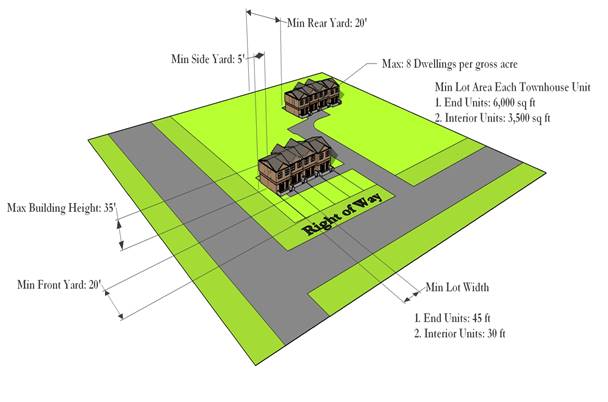
* Dependent on interior or exterior unit, see full text.
** Except where a larger yard is required to meet buffer yard standards as set forth in Section 404
ARTICLE XIII: TOWNHOUSE RESIDENTIAL DISTRICT (R-3)
SECTION 1300 – PURPOSE OF THIS DISTRICT
The purpose of this district is to provide areas for the development of two-family townhouse subdivisions. All areas zoned R-3 shall have public or any other approved sewerage.
SECTION 1301 – LAND USES PERMITTED
A. Two-family townhouses.
B. Accessory uses and structures associated with the use of the land for residential purposes.
C. Public or private recreational open space facilities, excluding country clubs and the like which shall be regulated as public/quasi-public facilities and utilities subject to the provision of Section 402 of this Zoning Ordinance. All lakes associated with this or any other usage shall comply with Rankin County Subdivision Regulations.
SECTION 1302 – CONDITIONAL USES AND STRUCTURES AS PROVIDED IN SECTION 2905
A. Three or four family townhouses.
B. Two, three or four family condominiums.
C. Public or quasi-public facilities and utilities in compliance with Section 402 and other regulations of this Zoning Ordinance.
D. Extraction of minerals, including sand and gravel, provided that when “open-pit” operations are conducted, the operator must obtain required permits and approvals from other governmental entities and provide Rankin County Board of Supervisors with written proof of the same. Mining operations may be approved through administrative review by the Department of Community Development. The Department of Community Development shall have review and approval authority. The Department of Community Development may defer review and approval to the Planning Commission.
E. Any other use which the Board of Supervisors determine meets the standards outlined under Section 2905.01.
SECTION 1303 – DIMENSIONAL REQUIREMENTS
1303.01 Minimum Size of Tract to be Subdivided for Two-Family Townhouses: Five (5) acres
1303.02 Maximum Building Height: 35 feet.
1303.03 Minimum Lot Area Each Townhouse Unit:
A. End units: 6,000 square feet
B. Interior units: 3,500 square feet
1303.04 Minimum Lot Width:
A. End units: 45 feet
B. Interior units: 30 feet
1303.05 Minimum Yards:
A. Front yard: 20 feet.
B. Side yards (end unit): 5 feet from each side lot line, except where abutting an R-1 district, then 30 feet, which shall remain open with no encroachments by driveways, patios or other paved areas. Furthermore, larger side yards may be required to meet the buffer yard standards set forth in Section 404.
C. Rear yard: 20 feet, except where abutting an R-1, R-1B or R-1C district, then 30 feet, which shall remain open with no encroachments by driveways, patios or other paved areas.
1303.06 Maximum Density: 8 dwelling units per gross acre.
SECTION 1304 – REQUIRED OPEN SPACE RESERVATION
Where a developer proposes a townhouse, the developer shall provide common open space amounting to fifteen percent (15%) of the total gross area of the subdivision. Such common open space shall consist of land reserved exclusively for the recreational use of the residents of the townhouse subdivision. The Development Plan shall indicate the location and area (in acres) to be so reserved or dedicated for open space or recreational facilities.
1304.01 Maximum Amount of Common Open Space Covered by Water: No more than fifty percent (50%) of the required amount of open space may be covered by lakes or ponds.
1304.02 Steep Slopes: In reviewing the preliminary subdivision plat for a proposed townhouse subdivision, the Board of Supervisors shall determine if any land containing slopes of twelve percent (12%) or greater may be included in the required common open space. This determination shall be based upon the developer's specific proposed use of the steep slope land. The Board of Supervisors shall decide whether or not any steep slope land should be approved for use in meeting the requirements of this Section.
1304.03 Physical Improvements: Common open space shall be suitably improved for the intended use, but open space containing natural features worthy of preservation may be left unimproved if such unimproved areas are approved by the Board of Supervisors as part of the preliminary subdivision plat review process. All open space improvements shall be shown on the sketch subdivision plat or development plan (approximate locations and dimensions and proposed use) and the preliminary and final plats (precise locations and dimensions and proposed use). Open space improvements may include pedestrian or bicycle trails, tennis courts, recreational buildings and swimming pools or similar facilities.
1304.04 Staged Development of a Townhouse Subdivision: If a townhouse subdivision is to be developed in stages or parts, fifteen percent (15%) of each part must be reserved for open space. However, in order to provide usable open space, the amount reserved shall not be less than one (1) acre. Thus, if a developer proposes to ultimately develop 20 acres of land for townhouses and the first phase will only contain five acres, the developer must reserve at least one (1) acre for open space for the first part--- even though 15% of 5 acres is only 3/4 acre. If the second part consists of 15 acres, the developer shall reserve 15% of the second part or 2.25 acres, in addition to the one acre reserved for the first phase; thus, the total open space reserved for the 20 acre tract developed in two phases would be 3.25 acres.
1304.05 Performance Bond: Prior to the sale of any lot in a townhouse subdivision, the developer may be permitted, at the discretion of the Board of Supervisors to post with the County a performance bond of sufficient surety to insure the completion of all proposed open space improvements (where applicable). Such performance bonds must be issued by a company that is licensed and permitted to do business in the State of Mississippi. The County Engineer in conjunction with the developer shall determine the amount of the performance bond after reviewing the construction plans for all improvements.
1304.06 Maintenance/Liability in the Operation and Use of Common Open Space and Recreational Areas: Authority granted by Rankin County for the development of a townhouse subdivision shall not be construed as nor constitute an obligation on the part of Rankin County either for maintenance or liability in the operation and use of common open space and recreational facilities located in the subdivision.
At the time the final subdivision plat is submitted for the townhouse subdivision, the developer shall submit with his application for final plat approval a legal instrument or instruments which state that the responsibility for liability insurance, taxes, and maintenance of open space and other common facilities shall rest with the owners of the several lots or parcels of land located within the townhouse subdivision. In order to insure the integrity of the open space so that it will remain genuinely open, the legal instrument(s) shall specify that the open space restrictions are permanent, not just for a period of years.
SECTION 1305 – PROPERTY LINES BETWEEN ADJOINING TOWNHOUSES
Any person desiring to construct townhouses shall prepare a sketch plat, preliminary plat and final plat indicating the approximate location of property lines between dwelling units. Following approval of the final plat, the builder who proposes such townhouses shall submit a plot diagram in accordance with the adopted building codes to the Building Inspector prior to the issuance of a building permit; said plot diagram shall indicate as nearly as possible the exact location of the property lines between the townhouses.
SECTION 1306 – UNDERGROUND UTILITY CONNECTIONS FOR TOWNHOUSES
All underground utilities (including water, sanitary sewer, electrical, natural gas, telephone, and cable television) shall be installed in such a manner that the utility lines do not cross the lots of adjoining townhouses, except where the utility line is placed in a utility easement required by this Zoning Ordinance. This provision is intended to prevent the need for excavation of the yards of adjoining townhouses for utility repairs. The construction drawings submitted by builders of townhouses shall indicate the proposed location of all utility lines on each lot, and these locations shall comply with this Section prior to issuance of a building permit.
SECTION 1307 – SITE PLAN REQUIRED
The developer of any townhouse subdivision or any conditional use specified in Section 1302 in the R-3 district shall submit a site plan to the Board of Supervisors in accordance with Section 2907 through 2910 of this Ordinance. Dimensional requirements for the proposed conditional use shall be established based upon site plan review.
High Density Residential District (R-4) Quick Reference Guide
|
|
||
Example of Land Uses Permitted Outright: |
Dimensional Requirements: |
|
Multiple Family Dwellings |
Maximum Building Height: |
35 feet* |
Accessory Buildings |
Minimum Floor Area: |
Varies* |
Any use permitted in R-3 |
Minimum Lot Area: |
Two Acres |
Minimum Lot Width: |
100 feet |
|
Minimum Yards: |
||
Front Yard: |
40 feet |
|
Side Yard: |
25 feet** |
|
Rear Yard: |
25 feet** |
|
Select Conditional Use: |
Buffer and Screening Requirements: |
|
Public/Quasi-Public Facilities |
Abutting Use Districts: All Agricultural and Residential Districts |
|
Child Care Facilities |
||
Mining |
Min Width: 10 ft |
Min Height: 6 ft |
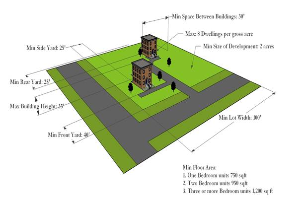
* Dependent on Unit Type
** Except where a larger yard is required to meet buffer yard standards as set forth in Section 404
ARTICLE XIV: HIGH DENSITY RESIDENTIAL DISTRICT (R-4)
SECTION 1400 – PURPOSE OF THIS DISTRICT
The purpose of this district is to provide areas for the development of higher density multiple family (i.e., three or more) residential uses with adequate, usable open space to prevent overcrowding. It is the intent of this Ordinance that these districts be carefully located only in areas where the infrastructure of the County (i.e., the road/highway system, storm drainage and water and sanitary sewer systems) is adequate to serve such higher density housing. The use of this district is appropriate as a transition between low density (R-1) or moderate density residential districts and higher intensity uses, such as commercial uses or limited industrial (I-1) uses, that are not compatible with lower density residential environment. All apartment developments shall front upon at least one road or highway that is classified as an Arterial or approved Collector Street.
SECTION 1401 – LAND USES PERMITTED
A. Any use permitted in R-3, subject to R-3 regulations.
B. Multiple family dwellings including apartments as defined in Article II.
C. Accessory uses or structures in multiple family residential complexes, including laundromats, vending machine centers, recreational buildings, swimming pools, tennis courts, and similar uses and structures incidental to multiple family buildings. Such uses and structures shall be reserved exclusively for use by residents and guests of residents of the multiple family complex.
SECTION 1402 – CONDITIONAL USES AND STRUCTURES AS PROVIDED IN SECTION 2905
A. Child care facilities.
B. Public or quasi-public facilities and utilities in compliance with Section 402 and other regulations of this Ordinance.
C. Extraction of minerals, including sand and gravel, provided that when “open-pit” operations are conducted, the operator must obtain required permits and approvals from other governmental entities and provide Rankin County Board of Supervisors with written proof of the same. Mining operations may be approved through administrative review by the Department of Community Development. The Department of Community Development shall have review and approval authority. The Department of Community Development may defer review and approval to the Planning Commission.
D. Any other use which the Board of Supervisors determine meets the standards outlined under Section 2905.01.
SECTION 1403 – DIMENSIONAL REQUIREMENTS
1403.01 Maximum Height: 35 feet unless greater height is specifically approved by the Board of Supervisors at the time the site plan is approved.
1403.02 Minimum Size of Development: Two (2) acres.
1403.03 Minimum Floor Area:
A. One bedroom units: 750 square feet.
B. Two bedroom units: 950 square feet.
C. Three or more bedroom units: 1,200 square feet.
1403.04 Maximum Density: 8 dwelling units per gross acre.
1403.05 Minimum Lot Width: 100 feet.
1403.06 Minimum Yards:
All yard shall be a landscaped open area with no encroachments permitted including parking lots, patios, swimming pools, or other paved areas except for entrance/exit driveways in Front Yards only.
A. Front yard: 40 feet.
B. Side and rear yards: 25 feet from each side lot line or rear lot line to any building, except where a side or rear lot line abuts an R-1, R-1B or R-1C district, in which case the side or rear yard shall be 50 feet from any building to the lot line abutting the R-1, R-1B or R-1C district. Furthermore, all yards must meet the buffer yard standards set forth in Section 404.
1403.07 Minimum Space between Buildings: No principal building or accessory building shall be constructed nearer than thirty (30) feet to any other principal building or accessory building.
SECTION 1404 – REQUIRED OPEN SPACE RESERVATION
A minimum of 30% of the gross site area to be developed for an apartment complex shall be devoted to open space. In calculating this open space requirement, the front, side and rear yards may be included. Parking lots and driveways, however, may not be included in calculating this required open space. The required site plan (see Section 2905) shall indicate the location and area (in acres) to be so reserved or dedicated for open space or recreational facilities.
1404.01 Maximum Amount of Common Open Space Covered by Water: No more than fifty percent (50%) of the required amount of open space may be covered by lakes or ponds.
1404.02 Steep Slopes: In reviewing the site plan for a proposed apartment development, the Board of Supervisors shall determine if any land containing slopes of twelve percent (12%) or greater may be included in the required common open space. This determination shall be based upon the developer's specific proposed use of the steep slope land. The Board of Supervisors shall determine whether or not any steep slope land should be approved for use in meeting the requirements of this Section.
1404.03 Physical Improvements: Common open space shall be suitably improved for the intended use, but open space containing natural features worthy of preservation may be left unimproved if such unimproved areas are approved by the Board of Supervisors as part of the site plan review process. Open space improvements may include pedestrian or bicycle trails, tennis courts, recreational buildings and swimming pools or similar facilities.
1404.04 Performance Bonds: Prior to the rental/ lease of any apartment, the developer may be permitted, at the discretion of the Board of Supervisors, to post with the County a performance bond of sufficient surety to insure the completion of all proposed open space improvements (where applicable). Such performance bonds must be issued by a company that is licensed and admitted to business in the State of Mississippi. The County Engineer in conjunction with the developer shall determine the amount of the performance bond after reviewing the construction plans for all improvements.
1404.05 Maintenance/Liability in the Operation and Use of Common Open Space Areas: Authority granted by Rankin County for the development of an apartment complex shall not be construed as, nor constitute, an obligation on the part of Rankin County either for maintenance or liability in the operation and use of common open space and recreational facilities located in the property.
At the time the final site plan is submitted for an apartment complex, the developer shall submit with his application for final plat approval a legal instrument or instruments which state that the assumption of liability insurance, taxes and maintenance of open space and other common facilities shall rest with the owners of the complex, a management company or a homeowners association. In order to insure the integrity of the open space so that it will remain genuinely open, the legal instrument(s) shall specify that the open space restrictions are permanent, not just for a period of years.
SECTION 1405 – SITE PLAN REQUIRED
The developer of any apartment complex or any conditional use specified in Section 1402 in the R-4 district shall submit a site plan to the Board of Supervisors in accordance with Sections 2907 through 2910 of this Ordinance. Dimensional requirements for the proposed conditional use shall be established based upon site plan review.
Planned Unit Development District (PUD) Quick Reference Guide
|
|
|||||
Example of Land Uses Permitted Outright: |
Dimensional Requirements: |
||||
Uses Allowed by Underlying Zoning |
Maximum Building Height: |
35 feet |
|||
Minimum PUD Area: |
Five Acres |
||||
Minimum Lot Width: |
None |
||||
Minimum Yards: |
|||||
Front Yard: |
*Per Underlying Zone |
||||
Side Yard: |
|||||
Rear Yard: |
|||||
Select Conditional Use: |
Buffer and Screening Requirements: |
||||
Public/Quasi-Public Facilities |
Abutting Use Districts: Per Underlying Zone |
||||
Child Care Facilities |
|||||
Mining |
Min Width: |
Min Height: |
|||
* Exceptions Listed, See Full Text
ARTICLE XV: PLANNED UNIT DEVELOPMENT DISTRICT (PUD)
SECTION 1500 – PURPOSE OF THIS DISTRICT
The purposes for establishing Planned Unit Development (PUD) districts are:
A. To provide for the development of relatively large land areas as total cohesive and coordinated units, rather than development on a lot-by-lot basis.
B. To permit more flexible and advantageous use of sites, especially with regard to natural features of the landscape, through the relaxation of conventional zoning requirements including minimum lot size and minimum lot width, while at the same time retaining approximately the same overall density as would ordinarily apply if the same areas were developed by conventional methods. (Note: However, minimum yard requirements are the same as for conventional districts.)
C. To help reduce the cost of residential development by allowing more dwelling units per gross acre than could be built in a conventional low density subdivision (due to the extensive space requirements of roads rights- of-way, utility easements, etc., in a conventional subdivision) and by reducing the length of roads and utility extensions through concentration or clustering of housing.
D. To provide for the development of sites in which land not used for structures and yards but not required by the basic zoning of the site shall be reserved collectively in contiguous units accessible to all dwellings within the PUD as open space; this open space will provide recreational opportunities for the residents of the PUD, and will also afford improved, safer pedestrian circulation within the PUD.
SECTION 1501 – PLANNED UNIT DEVELOPMENTS SHALL BE SUPERIMPOSED DISTRICTS
A PUD shall be a superimposed designation on a residential district, thereby providing a broader latitude of design to achieve the purposes stated under Section 1500. As a superimposed designation, PUD shall be subject to the overall density requirements of the residential district over which they are superimposed. The maximum residential density shall be calculated as prescribed under Section 1506.02.
SECTION 1502 – REZONING REQUIRED FOR DEVELOPMENT OF PORTION OF PUD FOR TOWNHOUSES, PATIO HOMES, MULTIPLE-FAMILY RESIDENTIAL, OR COMMERCIAL USES
If a person desires to reserve a portion of a proposed PUD for townhouses, patio homes, or multiple-family residential uses (condominiums or apartments), and such areas are not zoned appropriately for such densities, he shall submit an application for rezoning in accordance with Section 2906 of this Ordinance indicating which areas he desires to be rezoned.
Likewise, portions of a PUD may be reserved for commercial use by applying for the appropriate commercial zoning if the subject land is not zoned commercial on the Official Zoning Map.
If the subdivider wishes to reserve portions of the proposed PUD for moderate density or high density residential development or commercial use, such areas shall be shown on a sketch plat or “Development Plan,” which shall be submitted with an application for rezoning. A rezoning to permit such residential densities or commercial uses shall only be approved upon the condition that the preliminary plat and individual site plans (for the high density residential or commercial development) substantially conform to the sketch plat or development plan.
SECTION 1503 – LAND USES PERMITTED
The uses that are permitted outright in PUD districts are subject to the regulations and restrictions as prescribed in the initial underlying zone over which the PUD is superimposed.
SECTION 1504 – CONDITIONAL USES AND STRUCTURES AS PROVIDED IN SECTION 2905
A. Child care facilities.
B. Public or quasi-public facilities or utilities may be considered for location in a PUD district in compliance with Section 402 of this Ordinance.
C. Extraction of minerals, including sand and gravel, provided that when “open-pit” operations are conducted, the operator must obtain required permits and approvals from other governmental entities and provide Rankin County Board of Supervisors with written proof of the same. Mining operations may be approved through administrative review by the Department of Community Development. The Department of Community Development shall have review and approval authority. The Department of Community Development may defer review and approval to the Planning Commission.
D. Any other use which the Board of Supervisors determines meets the standards outlined under Section 2905.01.
SECTION 1505 – DIMENSIONAL REQUIREMENTS
1505.01 Minimum Size of PUD: The minimum size of any PUD shall be five (5) acres.
1505.02 Maximum Residential Development Density: The basic control of residential development density shall be the density requirement of the particular conventional district (i.e., R-1 or R-1B) over which the PUD is superimposed. The maximum density shall be calculated by dividing 43,560 square feet by the minimum lot size and then multiplying that quotient by the total gross acreage minus 10% for roads and ROW to be included in the PUD. EXAMPLE: If a subdivider proposes to develop a 30 acre tract zoned "R-1" as a PUD, the basic control of density is that of the R-1 district: 43,560 square feet divided by 11,500 square feet (minimum lot size in R-1 districts), resulting in a quotient of 3.78 lots or dwelling units; 27 acres multiplied by 3.78 = 102 lots or single-family detached dwelling units.
1505.03 Minimum Lot Size: No minimum.
1505.04 Minimum Lot Width: No minimum.
1505.05 Minimum Yards: The minimum yard requirements for single-family detached dwellings in PUD districts shall be the same as those required in R-1, R-1B or R1C or R-1D districts.
1505.06 Maximum Height: 35 feet, unless greater height is specifically approved by the Board of Supervisors.
SECTION 1506 – DIMENSIONAL REQUIREMENTS FOR TOWNHOUSES, PATIO HOMES, MULTIPLE FAMILY RESIDENTIAL AND COMMERCIAL PORTIONS OF A PUD
If an application for rezoning is approved to allow portions of a PUD to be used for townhouses, patio homes, condominiums or apartments, or some commercial classification, the dimensional requirements of the appropriate district shall apply.
SECTION 1507 – REQUIRED COMMON OPEN SPACE RESERVATION
Common open space shall be provided as a condition to the approval of a PUD. Such common open space shall consist of land reserved exclusively for the recreational use of the PUD residents and owned and maintained by the residents through a Homeowner's Association.
Common open space shall be integrated throughout the PUD, easily accessible to all the residents. The sketch plat or Development Plan shall indicate the location and area (in acres) to be so reserved for open space or recreational facilities.
1507.01 Minimum Percentage of Land Reserved as Common Open Space: Common open space shall comprise at least twenty percent (20%) of the gross area (total acreage) minus ten percent (10%) of the PUD as shown on the required development plan. Public roads shall not be considered in meeting the open space requirements of this section. Utility easements (electrical power, natural gas or other) may be used to meet the required common open space as required by this section, provided that portions of the utility easements that are so used shall be improved with the construction of pedestrian or bicycle trails or other improvements that are specifically approved by the Board of Supervisors. Unimproved raw land inside such easements shall in no case be considered in meeting these requirements.
1507.02 Maximum Amount of Common Open Space Covered By Water: No more than fifty percent (50%) of the required amount of open space may be covered by water (lakes, ponds, streams, storm water retention/detention, etc.)
1507.03 Steep Slopes: In reviewing the preliminary subdivision plat for a proposed PUD, the County Engineer shall determine if any land containing slopes of twelve percent (12%) or greater may be included in the required common open space. This determination shall be based upon the developer's specific proposed use of the steep slope land. The County Engineer shall make a recommendation to the Board of Supervisors as to whether or not any steep slope land should be approved for use in meeting the requirements of this Section.
1507.04 Physical Improvements: Common open space shall be suitably improved for the intended use, but open space containing natural features worthy of preservation may be left unimproved if such unimproved areas are approved by the Board of Supervisors as part of the preliminary subdivision plat review process.
All open space improvements shall be shown on the sketch subdivision plat or Development Plan (approximate locations and dimensions and proposed use) and the preliminary and final plats (precise locations and dimensions and proposed use). Open space improvements may include pedestrian or bicycle trails, tennis courts, recreational buildings and swimming pools or similar facilities.
1507.05 Staged Development of a Planned Unit Development: If a PUD is to be developed in stages or parts and the first part is to consist of the minimum of 5 acres, twenty percent (20%) must be reserved for open space, or one (1) acre. The open space requirements for subsequent parts or phases shall be calculated based upon the total open space requirement for the entire subdivision, including the initial phase or phases. Thus, if a developer proposes to ultimately develop 40 acres of land for a PUD and the first phase will only contain 5 acres, the developer must reserve a total of at least 6 acres for the entire subdivision, which may include the .75 acres reserved for the first part.
1507.06 Performance Bond Required: Prior to the sale of any lot in a PUD, the developer shall post with the County a performance bond of sufficient surety to insure the completion of all proposed open space improvements (where applicable). Such performance bonds must be issued by a company that is licensed and admitted to business in the State of Mississippi. The County Engineer in conjunction with the developer shall determine the amount of the performance bond after reviewing the construction plans for all improvements.
1507.07 Maintenance/Liability in the Operation and Use of Common Open Space Areas: Authority granted by Rankin County for the development of a PUD shall not be construed as, nor constitute, an obligation on the part of Rankin County either for maintenance or liability in the operation and use of common open space and recreational facilities located in the PUD.
At the time the final subdivision plat is submitted for a PUD, the developer shall submit with his application for final plat approval a legal instrument or instruments which state that the assumption of liability insurance, taxes and maintenance of open space and other common facilities shall rest with the owners of the several lots or parcels of land located within the PUD. In order to insure the integrity of the open space so that it will remain genuinely open, the legal instrument(s) shall specify that the open space restrictions are permanent, not just for a period of years.
SECTION 1508 – AS BUILT LETTER
Within 30 days of final plat approval, the engineer of record who submitted the site plan for a PUD shall provide the Zoning Administrator with a letter certifying that all density requirements set by the underlying zoning were adhered to.
SECTION 1509 – SITE PLAN REQUIRED
The developer of any PUD or any conditional use specified in Section 1502 in the PUD district shall submit a site plan to the Board of Supervisors in accordance with Sections 2907 through 2910 of this ordinance. Dimensional requirements for the proposed conditional use shall be established based upon site plan review.
Manufactured Home Park District (MHP) Quick Reference Guide
|
|
||
Example of Land Uses Permitted Outright: |
Dimensional Requirements: |
|
Single-Family Manufactured Homes |
Maximum Building Height: |
35 feet |
Private Recreational Facilities |
Minimum Park Size: |
Ten Acres |
Incidental Auxiliary Uses |
Minimum Lot Width: |
50 feet |
Accessory Uses and Structures |
Minimum Yards: |
|
Private Streets |
Front Yard: |
20 feet* |
Side Yard: |
10 feet* |
|
Rear Yard: |
10 feet* |
|
Select Conditional Use: |
Buffer and Screening Requirements: |
|
Public/Quasi-Public Facilities |
Abutting Use Districts: All Agricultural and Residential Districts |
|
Mining |
||
Min Width: 10 ft |
Min Height: 6 ft |
|
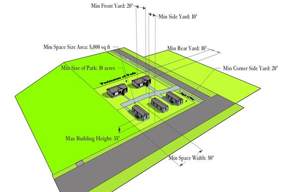
* Except where a larger yard is required to meet buffer yard standards as set forth in Section 404
ARTICLE XVI: MANUFACTURED HOME PARK DISTRICT (MHP)
SECTION 1600 – PURPOSE OF THIS DISTRICT
The purpose of this district is to provide for properly planned manufactured home parks in which spaces are offered on a rental or lease basis only for owner-occupied manufactured homes, or in which the space and manufactured home combination are both offered to the public on a rental or lease basis only.
SECTION 1601 – LAND USES PERMITTED
A. Single-family manufactured homes.
B. Private lakes, swimming pools, open space, and other private recreational facilities intended only for the use of the residents of the manufactured home park.
C. Laundromat, vending machine center, and related auxiliary uses incidental to the primary manufactured home uses, provided that such structures for auxiliary uses do not constitute over 10 percent of the total site area of the manufactured home park, and further provided that they be exclusively for the use of the residents of the manufactured home park.
D. Accessory uses and structures as defined under Article II of this Ordinance.
E. Private streets (circulation drives).
SECTION 1602 – CONDITIONAL USES AND STRUCTURES AS PROVIDED IN SECTION 2905
A. Public or quasi-public facilities and utilities in compliance with Section 402 and other regulations of this Ordinance.
B. Extraction of minerals, including sand and gravel, provided that when “open-pit” operations are conducted, the operator must obtain required permits and approvals from other governmental entities and provide Rankin County Board of Supervisors with written proof of the same. Mining operations may be approved through administrative review by the Department of Community Development. The Department of Community Development shall have review and approval authority. The Department of Community Development may defer review and approval to the Planning Commission.
C. Any other use which the Board of Supervisors determine meets the standards outlined under Section 2905.01.
SECTION 1603 – BUILDING PERMIT REQUIRED
Prior to the connection of utilities (water, sewer, electricity) to serve any manufactured home located in a manufactured home park, the owner of the manufactured home, or the owner (or his authorized representative) of the manufactured home park in cases where both the space and the manufactured home are leased or rented, shall apply for a building permit. All electrical wiring and plumbing connections shall be performed in accordance with the County’s adopted building code by qualified, licensed, and bonded electricians and plumbers.
Furthermore, any person responsible for placing a manufactured home in a manufactured home park shall comply with the tie down standards prescribed in the County’s adopted building code.
SECTION 1604 – DIMENSIONAL REQUIREMENTS
1604.01 Minimum Size of Park: 10 acres.
1604.02 Maximum Density: The maximum density shall not exceed six manufactured homes per gross acre.
1604.03 Maximum Building Height: 35 feet.
1604.04 Minimum Set-Backs for Park Perimeter: All manufactured homes shall be located at least thirty (30) feet from any property line or any existing or proposed right-of-way line of a public street or road. This park perimeter set-back shall be a landscaped open area with no encroachments permitted, including parking lots, patios, or swimming pools, or other paved areas except for entrance/exit driveways (front yard only). Furthermore, the park perimeter must meet the buffer yard standards set forth in Section 404.
1604.05 Minimum Manufactured Home Space Area Within the Park: 5,000 square feet.
1604.06 Minimum Space Width Within the Park: 50 feet.
1604.07 Required Set-Backs for Individual Manufactured Home Spaces Within the Park:
A. Front yard: There shall be a minimum distance of 20 feet between an individual manufactured home and the adjoining pavement of a park street, common parking area or other common areas.
B. Side yards: There shall be a minimum distance of 10 feet between all manufactured homes and the side yard lines of each manufactured home space (lot). On corner lots there shall be a minimum side yard of 20 feet on the corner side.
C. Rear yards: There shall be a minimum distance of 10 feet between all manufactured homes and the rear yard lines of manufactured home space (lot).
1604.08 Accessory Buildings or Uses: Accessory buildings or uses shall comply with the same height and yard requirements as manufactured homes. Accessory buildings or uses shall be located a minimum distance of 10 feet away from all manufactured homes or other main buildings within the manufactured home park.
SECTION 1605 – OFF-STREET PARKING REQUIREMENTS
In order to provide for free movement of traffic through the park on park streets, no on-street parking shall be permitted on any manufactured home park street. See Article XXVII for the off-street parking requirements of this district.
SECTION 1606 – PRIVATE STREETS WITHIN MANUFACTURED HOME PARKS
All streets (circulation drives) within a manufactured home park shall be at least 24 feet in width. Proper maintenance of all streets within manufactured home parks shall be the responsibility of the owner or operator of the park and not Rankin County.
SECTION 1607 – UTILITIES AND DRAINAGE
Utilities (electrical power, natural gas, water, and sanitary sewerage) and storm drainage shall be provided in all manufactured home parks in accordance with the requirements of the applicable codes adopted by Rankin County. The maintenance of water and sanitary sewage facilities and storm drainage facilities within manufactured home parks shall be the responsibility of the owner of the park.
SECTION 1608 – FREEDOM FROM FLOODING AND PONDING
All manufactured home parks shall be located on ground which is not susceptible to flooding and graded so as to prevent any water from ponding or accumulating on the premises.
SECTION 1609 – REFUSE COLLECTION FACILITIES
The owner, or his authorized representative, of a manufactured home park shall provide adequate refuse collection stations approved by the County for the proper storage of all refuse produced by residents of the manufactured home park, and shall be responsible for the cleanliness of the premises.
SECTION 1610 – EXTERIOR LIGHTING
Adequate street lights shall be provided by the park developer to illuminate all streets and walkways for the safe movement of vehicles and pedestrians at night.
SECTION 1611 – SITE PLAN REQUIRED
No building permit to construct a new manufactured home park or to expand (by the addition of one or more spaces) an existing manufactured home park shall be issued until the applicant for the building permit has complied with the provisions of Sections 2907 through 2910 relative to site plan review. All new manufactured home parks established after the effective date of this Ordinance shall comply with all of the provisions herein. With regard to manufactured home parks established prior to the effective date of this Ordinance, which are expanded (by the addition of one or more spaces) after the effective date hereof, the expanded portions of such parks shall comply with all applicable provisions of this Ordinance.
The developer of any conditional use specified in Section 1602 in the MHP district shall submit a site plan to the Board of Supervisors in accordance with Sections 2907 through 2910 of this Ordinance. Dimensional requirements for the proposed conditional use shall be established based upon site plan review.
Manufactured Home Subdivision District (MHS) Quick Reference Guide
|
|
||
Example of Land Uses Permitted Outright: |
Dimensional Requirements: |
|
Single-Family Manufactured Homes |
Maximum Building Height: |
35 feet |
Recreation/Open Space |
Minimum Lot Area: |
6,000 sf |
Accessory Uses and Structures |
Minimum Lot Width: |
60 feet |
Private Streets |
Minimum Yards: |
|
Front Yard: |
25 feet |
|
Side Yard: |
8 feet* |
|
Rear Yard: |
15 feet |
|
Select Conditional Use: |
Buffer and Screening Requirements: |
|
Public/Quasi-Public Facilities |
Abutting Use Districts: All Agricultural and Residential Districts |
|
Child Care Facility |
||
Mining |
Min Width: 10 ft |
Min Height: 6 ft |
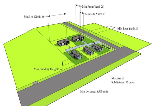
* Except where a larger yard is required to meet buffer yard standards as set forth in Section 404
ARTICLE XVII: MANUFACTURED HOME SUBDIVISION DISTRICT (MHS)
SECTION 1700 – PURPOSE OF THIS DISTRICT
The purpose of this district is to provide for properly planned manufactured home subdivisions in which lots are offered for sale, and in which the purchaser receives fee simple title to the lot. It is the intent of this Ordinance that these districts may be located only in such areas as to not adversely affect the established residential subdivisions in unincorporated Rankin County. Such location, however, shall have necessary public services, a healthful living environment and normal amenities associated with residential zones of the County.
SECTION 1701 – LAND USES PERMITTED
A. Single-family manufactured homes, either owner-occupied or on a rental or lease basis with only one dwelling per lot.
B. Accessory uses and structures associated with the use of the land for residential purposes.
C. Public or private recreational or open space facilities, excluding country clubs and the like which shall be regulated as public/quasi-public facilities and utilities subject to the provisions of Section 402 of this Zoning Ordinance. All lakes associated with this or any other usage shall comply with Rankin County Subdivision Regulations.
SECTION 1702 – CONDITIONAL USES AND STRUCTURES AS PROVIDED IN SECTION 2905
A. Child care facilities.
B. Public or quasi-public facilities and utilities in compliance with Section 402 and other regulations of this Zoning Ordinance.
C. Extraction of minerals, including sand and gravel, provided that when “open-pit” operations are conducted, the operator must obtain required permits and approvals from other governmental entities and provide Rankin County Board of Supervisors with written proof of the same. Mining operations may be approved through administrative review by the Department of Community Development. The Department of Community Development shall have review and approval authority. The Department of Community Development may defer review and approval to the Planning Commission.
D. Any other use which the Board of Supervisors determine meets the standards outlined under Section 2905.01.
SECTION 1703 – DIMENSIONAL REQUIREMENTS
1703.01 Minimum Size of Subdivision: 25 acres
1703.02 Maximum Building Height: 35 feet.
1703.03 Minimum Lot Area: 6,000 square feet.
1703.04 Minimum Lot Width: 60 feet.
1703.05 Minimum Yards:
A. Front yard: 25 feet.
B. Side yards: 8 feet, except where a larger side yard is required to meet buffer yard standards as set forth in Section 404.
C. Rear yard: 15 feet.
SECTION 1704 – COMPLIANCE WITH RANKIN COUNTY SUBDIVISION REGULATIONS
As with other residential subdivisions, the developers of a manufactured home subdivision shall comply with the Rankin County Subdivision Regulations, including preparation and submittal of subdivision plats and construction plans, and installation of all required subdivision improvements such as streets, water and sanitary sewer facilities, storm drainage facilities, etc.
SECTION 1705 – SITE PLAN REQUIRED
The developer of any manufactured home subdivision or any conditional use specified in Section 1702 in the MHS district shall submit a site plan to the Board of Supervisors in accordance with Sections 2907 through 2910 of this ordinance. Dimensional requirements for the proposed conditional use shall be established based upon site plan review.
Residential Mixed District (R-MX) Quick Reference Guide
|
|
||
Example of Land Uses Permitted Outright: |
Dimensional Requirements: |
|
Single-Family Dwelling |
Maximum Building Height: |
35 feet |
Factory Built Dwelling |
Minimum Lot Area: |
8,500 sf |
Accessory Uses and Structures |
Minimum Lot Width: |
80 feet |
Minimum Yards: |
||
Front Yard: |
25 feet |
|
Side Yard: |
5 feet* |
|
Rear Yard: |
20 feet |
|
Select Conditional Use: |
Buffer and Screening Requirements: |
|
Public/Quasi-Public Facilities |
Abutting Use Districts: All Agricultural and Residential Districts |
|
Mining |
||
Min Width: 10 ft |
Min Height: 6 ft |
|
* Except where a larger yard is required to meet buffer yard standards as set forth in Section 404
ARTICLE XVIII: RESIDENTIAL MIXED DISTRICT(R-MX)
SECTION 1800 – PURPOSE OF THIS DISTRICT
The purpose of this district is to provide for a zone in which a mixture of housing types are permitted.
SECTION 1801 – LAND USES PERMITTED
A. Single-family dwellings with only one dwelling per lot.
B. Manufactured homes with only one dwelling per lot.
C. Modular homes with only one dwelling per lot.
D. Panelized homes with only one dwelling per lot.
E. Pre-cut homes with only one dwelling per lot.
F. Accessory uses and structures associated with the use of the land for residential purposes.
SECTION 1802 – CONDITIONAL USES AND STRUCTURES AS PROVIDED UNDER SECTION 2905
A. Public or quasi-public facilities and utilities in compliance with section 402 and other regulations of this Ordinance.
B. Extraction of minerals, including sand and gravel, provided that when “open-pit” operations are conducted, the operator must obtain required permits and approvals from other governmental entities and provide Rankin County Board of Supervisors with written proof of the same. Mining operations may be approved through administrative review by the Department of Community Development. The Department of Community Development shall have review and approval authority. The Department of Community Development may defer review and approval to the Planning Commission.
C. Any other use which the Board of Supervisors determine meets the standards outlined under Section 2905.01.
SECTION 1803 – DIMENSIONAL REQUIREMENTS
1803.01 Maximum Building Height: 35 feet.
1803.02 Minimum Lot Area: 8,500 square feet.
1803.03 Minimum Lot Width: 80 feet.
1803.04 Minimum Yards:
A. Front yard: 25 feet.
B. Side yards: 5 feet, except where a larger side yard is required to meet buffer yard standards as set forth in Section 404.
C. Rear yard: 20 feet.
SECTION 1804 – SITE PLAN REQUIRED
The developer of any subdivision or any conditional use specified in Section 1802 in the R-MX district shall submit a site plan to the Board of Supervisors in accordance with Sections 2907 through 2910 of this ordinance. Dimensional requirements for the proposed conditional use shall be established based upon site plan review.
Restricted Business/Professional District (P-1) Quick Reference Guide
|
|
||
Example of Land Uses Permitted Outright: |
Dimensional Requirements: |
|
Businesses and Professional Offices |
Maximum Building Height: |
35 feet |
Personal Services, i.e. Hair Styling Shops |
Minimum Lot Area: |
None |
Instructional Services, i.e. Art Studio |
Minimum Lot Width: |
60 feet |
Privately-owned Museums, etc |
Minimum Yards: |
|
Residential Care Facilities |
Front Yard: |
40 feet* |
Select Conditional Use: |
Side Yard: |
10 feet* |
Public/Quasi-Public Facilities |
Rear Yard: |
20 feet* |
Business-related Retail and Service* |
Buffer and Screening Requirements: |
|
Restaurants, etc within Office Building |
Abutting Use Districts: All Agricultural and Residential Districts |
|
Educational/Training Facilities |
||
Condominiums/Loft-Apartments* |
Min Width: 20 ft |
Min Height: 6 ft |
Mining |
||
* Except where a larger yard is required to meet buffer yard standards as set forth in Section 404
ARTICLE XIX: RESTRICTED BUSINESS/PROFESSIONAL DISTRICT (P-1)
SECTION 1900 – PURPOSE OF THIS DISTRICT
The purpose of this district is to provide relatively quiet, attractive, and spacious areas for the development of non-retail restricted commercial uses that do not generate substantial volumes of vehicular traffic (i.e., generally, not more than approximately 70 average daily trips per 1,000 square feet of Gross Floor Area according to the National Cooperative Highway Research Program Report #187 or the latest edition of the Institute of Transportation Engineers manual entitled Trip Generation.) This district is intended to encourage high quality office park development and to serve as a transition zone between residential uses and higher intensity commercial uses or arterial streets. These districts are appropriate for the fringes of retail districts.
SECTION 1901 – LAND USES PERMITTED
A. Business and professional offices of all types.
B. Personal services such as hair styling shops and photographic portrait studios.
C. Instructional services such as studios for the teaching of fine arts, photography, music, drama and dance; business and stenographic schools; barber and beauty schools; and similar facilities.
D. Privately-owned and operated museums, libraries, galleries, and similar facilities.
E. Residential care facilities and ancillary uses commonly associated with any permitted use.
F. Any other use which the Board of Supervisors determine to be of the same character and nature as those specifically permitted above.
SECTION 1902 – CONDITIONAL USES AND STRUCTURES AS PROVIDED UNDER SECTION 2905
A. Business-related retail and service establishments not to exceed 25% of the leasable area of any office building or not to exceed 10,000 square feet if freestanding. Permitted uses include, but are not limited to, office supply stores, office equipment dealers, telecommunication equipment sales and service companies, computer stores and services, blueprint and copy services, graphics supply and equipment dealers; private employment agencies; travel agencies; emergency health care clinics; child care facilities; and totally enclosed health club facilities.
B. Restaurants, cafeterias, delicatessens, coffee shops and carry-out food establishments if located within an office building.
C. Educational and technical training facilities of all types except for those which require outdoor space and/ or industrial type structures or those that involve trucking or similarly sized equipment; included are conference center facilities.
D. Condominiums and loft-style apartments that are developed in connection with commercial establishments.
E. Public or quasi-public facilities and utilities in compliance with Section 402 of this Zoning Ordinance.
F. Extraction of minerals, including sand and gravel, provided that when “open-pit” operations are conducted, the operator must obtain required permits and approvals from other governmental entities and provide Rankin County Board of Supervisors with written proof of the same. Mining operations may be approved through administrative review by the Department of Community Development. The Department of Community Development shall have review and approval authority. The Department of Community Development may defer review and approval to the Planning Commission
G. Any other use which the Board of Supervisors determines meets the standards outlined under Section 2905.01.
SECTION 1903 – DIMENSIONAL REQUIREMENTS
1903.01 Maximum Building Height: 35 feet.
1903.02 Minimum Lot Area: No minimum lot area is required.
1903.03 Minimum Lot Width: 60 feet.
1903.04 Minimum Yards:
A. Front yard: 40 feet. The first ten (10) feet inside this front yard setback (adjacent to the street right-of-way line) shall remain open except for entrance/ exit driveways and shall be landscaped; no parking shall be permitted in driveways.
B. Side yards where NOT abutting an agricultural or residential district or residential use: 10 feet; the first five (5) feet inside this side yard setback (adjacent to the property line) shall be landscaped. The remainder of the side yard (between the landscaped five feet and the structure) may be used for driveways, parking, or other paved areas.
C. Rear yards where NOT abutting an agricultural or residential district or residential use: 20 feet; the first five (5) feet inside this rear yard setback (adjacent to the property line) shall be landscaped. The remainder of the rear yard (between the landscaped five feet and the structure) may be used for driveways, parking, or other paved areas.
D. Side yards and rear yards where abutting any agricultural or residential district or residential use: 20 feet, which shall meet the minimum buffer yard standards set forth in Section 404. All side or rear yards shall be landscaped open area with no encroachments permitted including driveways, parking lots, or other paved areas.
1903.05 Minimum Space between Buildings on the Same Lot: 30 feet. No more than two-thirds (2/3) of the space between such buildings shall be paved; the remaining area shall be landscaped.
SECTION 1904 – SITE PLAN REQUIRED
The developer of any use in a P-1 district shall submit a site plan to the Board of Supervisors in accordance with Sections 2907 through 2910 of this Zoning Ordinance. Dimensional requirements for the proposed conditional use shall be established based upon site plan review.
General Commercial District (C-2) Quick Reference Guide
|
|
|||
Example of Land Uses Permitted Outright: |
Dimensional Requirements: |
||
All Uses Allowed in P-1 |
Maximum Building Height: |
35 feet |
|
Enclosed Commercial Uses* |
Minimum Lot Area: |
Varies* |
|
Shopping Centers* |
Minimum Lot Width: |
Varies* |
|
Veterinary Clinics and Pet Shops* |
Minimum Yards: |
||
Front Yard: |
40 feet* |
||
Select Conditional Use: |
Side Yard: |
15 feet** |
|
Vehicle Sale/Rental |
Title Loan |
Rear Yard: |
20 feet** |
Plant Nurseries |
Convenience Store |
Buffer and Screening Requirements: |
|
Liquor Store |
Pawn Shops |
Abutting Use Districts: All Agricultural, Residential and P-1 Districts |
|
Public/Quasi Public Facilities and Utilities |
|||
Condominiums/Loft-Apartments* |
Min Width: 20 ft |
Min Height: 6 ft |
|
Mining |
Precious Metals |
||
* Exceptions Listed, See Full Text
** Except where a larger yard is required to meet buffer yard standards as set forth in Section 404
ARTICLE XX: GENERAL COMMERCIAL DISTRICT (C-2)
SECTION 2000 – PURPOSE OF THIS DISTRICT
The purpose of this district is to promote the development of well-planned shopping centers and independent commercial uses within carefully selected areas of the Board of Supervisors and Rankin County. The commercial activities permitted in this district include uses of a higher intensity than those first allowed in Restricted Business/Professional district (P-1). Although shopping center uses permitted in this zone require access to an arterial street, such uses are not "highway oriented" like those first allowed in the Major Thoroughfares Commercial District (C-3). Uses first permitted in C-3 Major Thoroughfares Commercial districts shall not be permitted in the C-2 district.
It is also the intent of this district that commercial uses permitted in C-2 districts be limited to those in which services performed and merchandise offered for sale be conducted or displayed entirely within enclosed structures as defined by this Ordinance.
It is the intent of this Ordinance that shopping centers and independent commercial uses be developed so that pedestrian and vehicular circulation is coordinated with the circulation patterns of adjacent properties in the vicinity that are also affected. In order to facilitate access between adjoining properties and to reduce the number of curb cuts onto arterial streets, the installation of a service drive shall be considered in connection with any independent commercial use (i.e., a commercial use that is not a part of a shopping center) proposed in this district.
SECTION 2001 – LAND USES PERMITTED
A. All uses allowed in P-1 Restricted Commercial district.
B. Commercial uses in which services performed and merchandise offered for sale are conducted or displayed within enclosed structures, except for the display of small articles (i.e., those that can generally be hand-carried by one or two persons) outside of the commercial use.
C. Shopping centers located on minimum sites of three (3) acres on an existing or proposed arterial street as shown on the adopted Thoroughfares Plan; shopping centers may contain any of the uses permitted outright in C-2 zones.
D. Veterinary clinics and pet shops, excluding outside runs.
E. Any other use which the Board of Supervisors determine to be of the same character and nature as those specifically permitted above.
SECTION 2002 – CONDITIONAL USES AND STRUCTURES AS PROVIDED UNDER SECTION 2905
A. Vehicle sales, rental or lease and vehicle service.
B. Plant nurseries.
C. Liquor stores. (No such establishment shall be located within five hundred (500) feet of the property lines of any existing residential use or any residentially zoned property, church, school, hospital, convalescent or nursing home, cemetery, civic organization building or facility, charitable organization building or facility, public or private park or playground, or any property zoned "S-1" Special Use district under this Ordinance.)
D. Condominiums and loft-style apartments that are developed in connection with commercial establishments.
E. Convenience stores.
F. Pawn Shops.
G. Tattoo Parlors.
H. Title loan and check cashing establishments.
I. Businesses purchasing gold or other precious metals as a primary business.
J. Public or quasi-public facilities and utilities in compliance with 402 and other regulations of this Ordinance.
K. Extraction of minerals, including sand and gravel, provided that when “open-pit” operations are conducted, the operator must obtain required permits and approvals from other governmental entities and provide Rankin County Board of Supervisors with written proof of the same. Mining operations may be approved through administrative review by the Department of Community Development. The Department of Community Development shall have review and approval authority. The Department of Community Development may defer review and approval to the Planning Commission.
L. Any other use which the Board of Supervisors determine meets the standards outlined under Section 2905.01.
SECTION 2003 – DIMENSIONAL REQUIREMENTS
2003.01 Maximum Building Height: 35 feet, unless greater height is approved by the Board of Supervisors.
2003.02 Minimum Lot Area:
A. Shopping centers: Three (3) acres.
B. Independent commercial uses: 30,000 square feet.
2003.03 Minimum Lot Width:
A. Shopping centers: 200 feet.
B. Independent commercial uses: 100 feet.
2003.04 Minimum Yards: The minimum yard requirements for all uses permitted in a C-2 district shall be as follows:
A. Front yard: 40 feet. The first ten (10) feet inside this front yard setback shall remain open except for entrance/ exit driveways and shall be landscaped; no parking shall be permitted in driveways within the first ten (10) feet of the front yard setback.
B. Side yards where NOT abutting an agricultural or residential district or residential use: fifteen (15) feet; the first five (5) feet inside this side yard setback adjacent to the property line) shall be landscaped. The remainder of the side yard (between the landscaped five feet and the structure) may be used for driveways, parking, or other paved areas. Furthermore, all yards must meet the buffer yard standards set forth in Section 404.
C. Rear yards where NOT abutting an agricultural or residential district or residential use: twenty (20) feet; the first five (5) feet inside this rear yard setback (adjacent to the property line) shall be landscaped. The remainder of the rear yard (between the landscaped five feet and the structure) may be used for driveways, parking, or other paved areas. Furthermore, all yards must meet the buffer yard standards set forth in Section 404.
D. Side yards and rear yards where abutting any agricultural or residential district or residential use: 20 feet, which shall meet all minimum buffer yard standards set forth in Section 404. All side or rear yards shall be landscaped open area with no encroachments permitted including driveways, parking lots, or other paved areas.
2003.05 Minimum Space between Separate (Detached) Buildings on the Same Lot: 30 feet. No more than two-thirds (2/3) of the space between such buildings shall be paved; the remaining area shall be landscaped.
SECTION 2004 – SITE PLAN REQUIRED
The developer of any use in a C-2 district shall submit a site plan to the Board of Supervisors in accordance with Sections 2907 through 2910 of this Zoning Ordinance. Dimensional requirements for the proposed conditional use shall be established based upon site plan review.
Major Thoroughfares Commercial District (C-3) Quick Reference Guide
|
|
|||
Example of Land Uses Permitted Outright: |
Dimensional Requirements: |
||
All Uses Allowed in C-2 |
Maximum Building Height: |
35 feet |
|
Vehicle & Boat/Marine Sale/Rental |
Minimum Lot Area: |
Varies* |
|
Enclosed Warehouse and Storage |
Minimum Lot Width: |
100 feet |
|
Convenience Store |
Minimum Yards: |
||
Select Conditional Use: |
Front Yard: |
40 feet* |
|
Manufactured Homes/RV Sales/Service |
Side Yard: |
20 feet** |
|
Building Materials |
Truck Stops |
Rear Yard: |
20 feet** |
Equipment Sales* |
Fireworks |
Buffer and Screening Requirements: |
|
Liquor Store |
Vet Clinics* |
Abutting Use Districts: All Agricultural, Residential and P-1 Districts |
|
Commercial Recreational/Entertainment |
|||
Public/Quasi Public Facilities and Utilities |
Min Width: 20 ft |
Min Height: 6 ft |
|
Mining |
Bars |
||
* Exceptions Listed, See Full Text
** Except where a larger yard is required to meet buffer yard standards as set forth in Section 404
ARTICLE XXI: MAJOR THOROUGHFARES COMMERCIAL DISTRICT (C-3)
SECTION 2100 – PURPOSE OF THIS DISTRICT
The purpose of this district is to provide relatively spacious areas for the development of vehicle-oriented commercial activities which typically require direct auto traffic access and visibility from major thoroughfares. This district is intended to encourage those commercial activities which function relatively independent of intensive pedestrian traffic and proximity to other commercial establishments. In accordance with the adopted Goals and Objectives of the Comprehensive Plan of Rankin County, the outdoor commercial uses (i.e., those in which all or much of the business is conducted out-of-doors) first permitted outright in this district shall be located well away from all residential uses.
These districts are appropriate for the fringes of retail districts and only along major thoroughfares designated as arterial roads on the adopted Transportation Plan. Uses first permitted in C-4 Adult Entertainment districts, I-1 Limited Industrial districts, and I-2 Heavy Industrial districts shall not be permitted in C-3 districts.
SECTION 2101 – LAND USES PERMITTED
A. Any use permitted in the C-2 General Commercial District, subject to all regulations of that District.
B. Vehicle sales, rental or lease and vehicle service.
C. Boat and marine sales, rental or lease, and service.
D. Warehousing and storage, provided that all storage is within enclosed structures; such as mini-warehouses.
E. Convenience stores.
F. Other similar enterprises or businesses of the same nature which are not more obnoxious or detrimental to the welfare of the particular area than the enterprises permitted above, not to include those uses which are first permitted in the I-1 District.
SECTION 2102 – CONDITIONAL USES AND STRUCTURES AS PROVIDED UNDER SECTION 2905
A. Commercial recreational and entertainment enterprises in which all or part of the activities are conducted out-of-doors, such as golf driving or putting courses, water amusement parks, drive-in theaters, etc.
B. Building materials sales where some or all such materials are displayed outdoors or are visible from roads or highways.
C. Heavy construction equipment sales and service.
D. Manufactured home and recreational vehicle sales and service.
E. Truck stops.
F. Veterinary clinics with outside dog runs.
G. Bars, excluding all adult entertainment uses. No such establishment shall be located within five hundred (500) feet of the property lines of any existing residential use or any residentially zoned property, church, school, hospital, convalescent or nursing home, cemetery, civic organization building or facility, charitable organization building or facility, public or private park or playground, or any property zoned "S-1" Special Use district under this Ordinance.
H. Liquor stores. No such establishment shall be located within five hundred (500) feet of the property lines of any existing residential use or any residentially zoned property, church, school, hospital, convalescent or nursing home, cemetery, civic organization building or facility, charitable organization building or facility, public or private park or playground, or any property zoned "S-1" Special Use district under this Ordinance.
I. Sale of fireworks.
J. Public or quasi-public facilities and utilities in compliance with Section 402 and other regulations of this Ordinance.
K. Extraction of minerals, including sand and gravel, provided that when “open-pit” operations are conducted, the operator must obtain required permits and approvals from other governmental entities and provide Rankin County Board of Supervisors with written proof of the same. Mining operations may be approved through administrative review by the Department of Community Development. The Department of Community Development shall have review and approval authority. The Department of Community Development may defer review and approval to the Planning Commission.
L. Any other use which the Board of Supervisors determine meets the standards outlined under Section 2905.01.
SECTION 2103 – DIMENSIONAL REQUIREMENTS
2103.01 Maximum Building Height: 35 feet, unless greater height is approved by the Board of Supervisors.
2103.02 Minimum Lot Area:
A. Shopping centers: three (3) acres.
B. Independent commercial uses: 10,000 square feet.
2103.03 Minimum Lot Width: 100 feet.
2103.04 Minimum Yards:
A. Front yard: 40 feet. The first ten (10) feet inside this front yard setback shall remain open except for entrance/exit driveways and shall be landscaped; no parking shall be permitted in these driveways.
B. Side yards and rear yards where NOT abutting an agricultural or residential district or residential use: 20 feet; the first five (5) feet inside this side or rear yard setback (adjacent to the property line) shall be landscaped. Furthermore, all yards must meet the buffer yard standards set forth in Section 404.
C. Side yards and rear yards where abutting an agricultural or residential district or residential use: 20 feet, which shall meet all minimum buffer yard standards set forth in Section 404.
2103.05 Minimum Space between Separate (Detached) Buildings on the Same Lot: 30 feet. No more than two-thirds (2/3) of the space between such buildings shall be paved; the remaining area shall be landscaped in accordance with standards adopted by Rankin County.
SECTION 2104 – SITE PLAN REQUIRED
The developer of any use in a C-3 district shall submit a site plan to the Board of Supervisors in accordance with Sections 2907 through 2910 of this Ordinance. Dimensional requirements for the proposed conditional use shall be established based upon site plan review.
Adult Entertainment Commercial District (C-4) Quick Reference Guide
|
|
||
Example of Land Uses Permitted Outright: |
Dimensional Requirements: |
|
All Uses Allowed in P-1, C-2, and C-3 |
Maximum Building Height: |
35 feet |
Adult Entertainment Use |
Minimum Lot Area: |
Site Plan Review |
Minimum Lot Width: |
Site Plan Review |
|
Minimum Yards: |
||
|
Front Yard: |
40 feet |
Side Yard: |
20 feet** |
|
Rear Yard: |
20 feet** |
|
Select Conditional Use: |
Buffer and Screening Requirements: |
|
Conditional Uses Allowed in P-1, C-2 or C-3 |
Abutting Use Districts: All Agricultural, Residential and P-1 Districts |
|
Public/Quasi Public Facilities and Utilities |
||
Mining |
Min Width: 30 ft |
Min Height: 6 ft |
* Exceptions Listed, See Full Text
** Except where a larger yard is required to meet buffer yard standards as set forth in Section 404
ARTICLE XXII: ADULT ENTERTAINMENT COMMERCIAL DISTRICT (C-4)
SECTION 2200 – PURPOSE OF THIS DISTRICT
The purpose of this district is to regulate the operation and location of adult entertainment establishments, as defined by this Ordinance, for the purposes of: (1) stemming a potential increase in criminal activities and disturbances of the peace and good order of Rankin County; (2) maintaining property values; (3) preventing injuries to residential neighborhoods and other commercial districts; (4) protecting and preserving the quality of life through effective land use planning.
The Board of Supervisors have found that there is substantial evidence, including numerous studies, reports and findings on the potential harmful effect of adult entertainment uses made by cities, experts, urban planners, etc., which document that such uses adversely affect property values, cause an increase in crime, encourage businesses to move elsewhere, and contribute to neighborhood blight.
Therefore, this district is intended to regulate adult entertainment uses to insure that these adverse effects will not contribute to blighting or downgrading of surrounding neighborhoods.
SECTION 2201 – LAND USES PERMITTED
A. Any uses permitted outright in P-1 Restricted Business/Professional districts, C-2 General Commercial districts and C-3 Major Thoroughfares Commercial districts.
B. Adult arcades, adult bookstores, adult cabarets, adult motels, adult motion picture theaters, and other adult entertainment activities as defined by this Ordinance. However, no such establishment shall be located within two hundred fifty (250) feet of the property line of any other such use. Furthermore, no such establishment shall be located within one thousand (1,000) feet of the property lines of any existing residential use or any residentially zoned property, church, school, hospital, convalescent or nursing home, cemetery, civic organization building or facility, charitable organization building or facility, public or private park or playground, or any property zoned "S-1" Special Use district under this Ordinance.
C. Any other use which the Board of Supervisors determine to be of the same character and nature as those specifically permitted above.
SECTION 2202 – CONDITIONAL USES AND STRUCTURES AS PROVIDED UNDER SECTION 2905
A. Other uses that may be considered as Conditional Use for location in P-1 Restricted Business/Professional districts, C-2 General Commercial, or C-3 Major Thoroughfares Commercial districts.
B. Public or quasi-public facilities in compliance with Section 402 and other regulations of this Ordinance. However, see Section 2201 for the minimum distance between adult entertainment uses and certain public/ quasi-public uses.
C. Extraction of minerals, including sand and gravel, provided that when “open-pit” operations are conducted, the operator must obtain required permits and approvals from other governmental entities and provide Rankin County Board of Supervisors with written proof of the same. Mining operations may be approved through administrative review by the Department of Community Development. The Department of Community Development shall have review and approval authority. The Department of Community Development may defer review and approval to the Planning Commission.
D. Other similar enterprises or businesses of the same nature which are not more obnoxious or detrimental to the welfare of the particular area than the enterprises permitted above, not to include those uses which are first permitted in the I-1 District. Uses not specifically listed above shall be reviewed by the Board of Supervisors.
E. Any other use which the Board of Supervisors determine meets the standards outlined under Section 2905.01.
SECTION 2203 – DIMENSIONAL REQUIREMENTS
2203.01 Maximum Building Height: 35 feet, unless greater height is approved by the Board of Supervisors.
2203.02 Minimum Lot Area: Based upon required Site Plan Review.
2203.03: Minimum Lot Width: Based upon required Site Plan Review.
2203.04 Minimum Yards:
A. Front yard: 40 feet.
B. Side yards: 20 feet, except where a larger yard is required to meet buffer yard standards as set forth in Section 404
C. Rear yards: 20 feet, except where a larger yard is required to meet buffer yard standards as set forth in Section 404.
This 20 foot Side or Rear yard setback shall be in addition to the minimum distance (1,000 feet) required between all existing residential uses, residential zones, any public/ quasi-public use listed under Section 2201-B and any Special Use (S-1) district.
2203.05 Minimum Space between Separate (Detached) Buildings on the Same Lot: 30 feet. No more than two-thirds (2/3) of the space between such buildings shall be paved; the remaining area shall be landscaped.
SECTION 2204 – SITE PLAN REQUIRED
The developer of any use in a C-4 district shall submit a site plan to the Board of Supervisors in accordance with Sections 2907 through 2910 of this Ordinance. Dimensional requirements for the proposed conditional use shall be established based upon site plan review.
Limited Industrial District (I-1) Quick Reference Guide
|
|
|||
Example of Land Uses Permitted Outright: |
Dimensional Requirements: |
||
All Uses Allowed in C-2 and C-3 |
Maximum Building Height: |
35 feet |
|
Light Manufacturing in Enclosed Area |
Minimum Lot Area: |
20,000 sf |
|
Food Product Processing |
Minimum Lot Width: |
100 feet |
|
Minimum Yards: |
|||
|
Front Yard: |
50 feet |
|
Side Yard: |
15 feet* |
||
Rear Yard: |
20 feet* |
||
Buffer and Screening Requirements: |
|||
Select Conditional Use: |
Abutting Use Districts: All Districts except I-2 |
||
Television and Radio Transmitters |
|||
Public/Quasi Public Facilities and Utilities |
Min Width: 30 ft |
Min Height: 6 ft |
|
Mining |
|||
* Except where a larger yard is required to meet buffer yard standards as set forth in Section 404
ARTICLE XXIII: LIMITED INDUSTRIAL DISTRICT (I-1)
SECTION 2300 – PURPOSE OF THIS DISTRICT
The purpose of this district is to provide areas for the exclusive development of limited manufacturing and industrial uses within enclosed structures. It is the intent of this Ordinance that I-1 land uses be compatible with abutting districts, such as commercial districts, which will serve as transitional zones between the industrial users and the lower intensity residential uses. The uses permitted in I-1 districts shall generate no objectionable odor, smoke, fumes, vibration, or excessive noise. Such limited industrial and related uses shall be located only in areas directly accessible to major thoroughfares or railroads. It is further the intent of this Ordinance that encroachment by all residential uses be prohibited.
SECTION 2301 – LAND USES PERMITTED
The following land uses shall be permitted in I-1 districts, provided such uses conform to standards established by appropriate Federal and State regulatory agencies:
A. Any uses permitted in C-2 General Commercial and C-3 Major Thoroughfares Commercial districts, subject to all regulations of the C-2 and C-3 Districts.
B. Light or limited manufacturing conducted wholly within completely enclosed buildings, except that the temporary storage of articles, materials, or other matter to be processed, assembled, or otherwise changed may be permitted if adequately screened or buffered. The manufacturing activities conducted in I-1 districts shall, in general, be dependent upon raw materials refined elsewhere. The following limited manufacturing uses shall be permitted, provided they are not offensive to neighboring land uses due to the emission of dust, gas, smoke, noise, fumes, odors, vibrations, fire hazards, or other objectionable influences.
C. Processing, canning, packaging and other treatment of food products, including: bakery products, confectionary and related products, fruit and vegetable products, fish, poultry and other meat products, excluding the rendering or refining of fats and oils and the slaughtering of animals.
D. Manufacturing, assembly or other treatment of products from the following secondary materials (previously prepared or refined materials): plastics, glass, paper, precious or semi-precious metals or stones, tobacco, and wood (excluding sawmills).
E. Fabrication of metal products including the manufacture of: machinery (engines and turbines, farm machinery and equipment, etc.); electrical equipment and supplies; transportation equipment (including motor vehicles and parts, aircraft and parts, motorcycles, bicycles and parts, etc.); and other secondary metal manufacturing such as metal cans, cutlery, hand tools, and general hardware, heating apparatus and plumbing fixtures, metal stamping, fabricated wire products, and coating, engraving and allied services.
F. Manufacturing of pottery or similar ceramic products (using only previously prepared or pulverized clay, and kilns fired only by electricity or natural gas).
G. Manufacturing of professional, scientific, and controlling instruments; photographic or optical goods; watches and clocks.
H. Manufacturing of textile mill products, including broad and narrow woven fabrics and other small wares (cotton, man-made fibers, silk and wool), floor coverings (rugs and carpets), yarns and similar products.
I. Manufacturing of apparel and other finished products made from fabrics, leather, fur and similar materials.
J. Assembly, painting, upholstering and similar activities in connection with automobiles, trucks, farm machinery, mobile homes and related products.
K. Warehousing and storage; such warehousing may include the storage of goods manufactured on the premises as well as goods manufactured off the site, including mini-warehouses.
L. Dwellings for resident watchmen and caretakers employed on the premises of the primary permitted use.
M. Other similar enterprises which are of the same character and nature as those specifically permitted above, but not to include those uses first permitted in the I-2 Heavy Industrial district.
SECTION 2302 – CONDITIONAL USES AND STRUCTURES AS PROVIDED IN SECTION 2905
A. Television and radio transmitters.
B. Public and quasi-public facilities and utilities may be allowed in this district in compliance with Section 402 of this Ordinance and subject to any limitations and restrictions deemed necessary by the Board of Supervisors.
C. Extraction of minerals, including sand and gravel, provided that when “open-pit” operations are conducted, the operator must obtain required permits and approvals from other governmental entities and provide Rankin County Board of Supervisors with written proof of the same. Mining operations may be approved through administrative review by the Department of Community Development. The Department of Community Development shall have review and approval authority. The Department of Community Development may defer review and approval to the Planning Commission.
D. Any other use which the Board of Supervisors determines meets the standards outlined under Section 2905.01.
SECTION 2303 – DIMENSIONAL REQUIREMENTS
2303.01 Maximum Building Height: 35 feet, unless greater height is approved by the Board of Supervisors.
2303.02 Minimum Lot Area: 20,000 square feet.
2303.03 Minimum Lot Width: 100 feet.
2303.04 Minimum Yards:
A. Front yard: 50 feet. The first ten (10) feet inside this front yard setback (adjacent to the street right-of-way line) shall remain open except for entrance/exit driveways and shall be landscaped; no parking shall be permitted in driveways within the first ten (10) feet of the front yard setback.
B. Side yards where NOT abutting an agricultural or residential district or residential use: fifteen (15) feet; the first five (5) feet inside this side yard setback (adjacent to the property line) shall be landscaped. The remainder of the side yard (between the landscaped five feet and the structure) may be used for driveways, parking, or other paved areas. Except where a larger yard is required to meet buffer yard standards as set forth in Section 404, then the minimum yard size must meet buffer yard standards.
C. Rear yards where NOT abutting an agricultural or residential district or residential use: twenty (20) feet; the first five (5) feet inside this rear yard setback (adjacent to the property line) shall be landscaped. The remainder of the rear yard (between the landscaped five feet and the structure) may be used for driveways, parking, or other paved areas. Except where a larger yard is required to meet buffer yard standards as set forth in Section 404, then the minimum yard size must meet buffer yard standards.
D. Side yards and rear yards where abutting an agricultural or residential district or residential use: 30 feet, which shall meet all minimum buffer yard standards set forth in Section 404.All side or rear yards shall be landscaped open area with no encroachments permitted including driveways, parking lots, or other paved areas.
2303.5 Minimum Space between Separate (Detached) Buildings on the Same Lot: 30 feet, No more than two-thirds (2/3) of the space between such buildings shall be landscaped.
SECTION 2304 – SITE PLAN REQUIRED
The developer of any use in an I-1 district shall submit a site plan to the Board of Supervisors in accordance with Sections 2907 through 2910 of this Ordinance. Dimensional requirements for the proposed conditional use shall be established based upon site plan review.
Heavy Industrial District (I-2) Quick Reference Guide
|
|
|||
Example of Land Uses Permitted Outright: |
Dimensional Requirements: |
||
All Uses Allowed in I-1 |
Maximum Building Height: |
35 feet |
|
Manufacturing, Outdoor |
Minimum Lot Area: |
One acre |
|
Warehousing |
Minimum Lot Width: |
200 feet |
|
Television and Radio Transmitters |
Minimum Yards: |
||
|
Front Yard: |
50 feet |
|
Select Conditional Use: |
Side Yard: |
15 feet** |
|
Conditional Use of I-1 |
Rear Yard: |
20 feet** |
|
Primary Metal Manufacturing |
Buffer and Screening Requirements: |
||
Salvage/Auto Wrecking Yards |
Abutting Use Districts: All Districts except I-1 |
||
Large Water Consumption/Discharge* |
|||
Public/Quasi Public Facilities and Utilities |
Min Width: 30 ft |
Min Height: 6 ft |
|
Mining |
|||
* Exceptions Listed, See Full Text
** Except where a larger yard is required to meet buffer yard standards as set forth in Section 404
ARTICLE XXIV: HEAVY INDUSTRIAL DISTRICT (I-2)
SECTION 2400 – PURPOSE OF THIS DISTRICT
The purpose of this district is to provide areas for the exclusive development of industrial uses involving manufacturing activities that are conducted out-of-doors or storage of materials out-of-doors. This district also includes manufacturing uses that use large amounts of water to process products or discharge large volumes of wastewater into the sewage system. These industrial uses generally have extensive space requirements and/ or generate substantial amounts of noise, vibration, odors, or possess other objectionable characteristics. It is the intent of this Ordinance that such "heavy" industrial districts be located insofar as possible adjacent only to C-3 Major Thoroughfare Commercial or I-1 Limited Industrial districts, which shall serve as transitional zones between I-2 districts and residential uses and lower intensity commercial uses. Heavy industrial uses shall be located only in areas directly accessible to major thoroughfares or railroads.
SECTION 2401 – LAND USES PERMITTED
The land uses first permitted in I-2 districts may include those where manufacturing or storage of materials occurs outside of enclosed structures as well as those within enclosed structures, subject to the regulations of this Ordinance and standards established by appropriate Federal and State regulatory agencies. The following uses are permitted outright:
A. Any use permitted in an I-1 district, subject to I-1 regulations.
B. Manufacturing activities conducted entirely or partially out-of-doors, such as cement manufacturing and sawmills.
C. Warehousing uses.
D. Television and radio transmitters.
E. Any other use which the Board of Supervisors determine to be of the same character and nature as those specifically permitted above.
SECTION 2402 – CONDITIONAL USES AND STRUCTURES AS PROVIDED IN SECTION 2905
A. Any conditional use listed under I-1 district regulations, subject to I-1 regulations.
B. Primary metal manufacturing, including: blast furnaces, steel works, and the rolling and finishing of ferrous metals; iron and steel foundries; primary smelting and refining of non-ferrous metals; and similar activities.
C. Any manufacturing activity requiring large amounts of water for processing or discharging large amounts of waste or by-products into the sewer system.
D. Mining, quarrying and crude petroleum and natural gas production (including sand and gravel pits and rock-crushing operations). When "open-pit" mining operations are conducted, the operator must obtain required permits and approvals from other governmental entities and provide the Board of Supervisors with written proof of same. Mining operations may be approved through administrative review by the Department of Community Development. The Department of Community Development shall have review and approval authority. The Department of Community Development may defer review and approval to the Planning Commission.
E. Salvage yards and auto wrecking yards.
F. Public and quasi-public facilities and utilities may be allowed in this district in compliance with Section 402 of this Ordinance and subject to any limitations and restrictions deemed necessary by the Board of Supervisors.
G. Any other use of a heavy industrial nature which is not otherwise prohibited by law may be initiated in I-2 districts, subject to any limitations and restrictions deemed necessary by the Board of Supervisors.
SECTION 2403 – DIMENSIONAL REQUIREMENTS
2403.01 Maximum Building Height: 35 feet, unless greater height is approved by the Board of Supervisors.
2403.02 Minimum Lot Area: One (1) acre.
2403.03 Minimum Lot Width: 200 feet.
2403.04 Minimum Yards:
A. Front yard: 50 feet. The first ten (10) feet inside this front yard setback (adjacent to the street right-of-way line) shall remain open except for entrance/ exit driveways and shall be landscaped; no parking shall be permitted in driveways within the first ten feet of the front yard setback.
B. Side yards where NOT abutting an agricultural or residential district or residential use: fifteen (15) feet; the first five (5) feet inside this side yard setback (adjacent to the property line) shall be landscaped. The remainder of the side yard (between the landscaped five feet and the structure) may be used for driveways, parking, or other paved areas. Except where a larger yard is required to meet buffer yard standards as set forth in Section 404, then the minimum yard size must meet buffer yard standards.
C. Rear yards where NOT abutting an agricultural or residential district or residential use: twenty (20) feet; the first five (5) feet inside this rear yard setback (adjacent to the property line) shall be landscaped. The remainder of the rear yard (between the landscaped five feet and the structure) may be used for driveways, parking, or other paved areas. Except where a larger yard is required to meet buffer yard standards as set forth in Section 404, then the minimum yard size must meet buffer yard standards.
D. Side yards and rear yards where abutting an agricultural residential district or residential use: 30 feet, which shall meet all minimum buffer yard standards set forth in Section 404. All side or rear yards shall be landscaped open area with no encroachments permitted including driveways, parking lots, or other paved areas.
2403.05 Minimum Space between Separate (Detached) Buildings on the Same Lot: 30 feet. No more than two-thirds (2/3) of the space between such buildings shall be paved; the remaining area shall be landscaped.
SECTION 2404 – SITE PLAN REQUIRED
The developer of any use in an I-2 district shall submit a site plan to the Board of Supervisors in accordance with Sections 2907 through 2910 of this Ordinance. Dimensional requirements for the proposed conditional use shall be established based upon site plan review.
Special Use District (S-1) Quick Reference Guide
|
|
|||
Example of Land Uses Permitted Outright: |
Dimensional Requirements: |
||
Large Scale Educational Institutions* |
Maximum Building Height: |
35 feet |
|
Comprehensive Retirement Facilities* |
Minimum Lot Area: |
Site Plan Review |
|
All Airports |
State Parks |
Minimum Lot Width: |
None |
National Forest Lands |
Minimum Yards: |
||
|
Front Yard: |
50 feet* |
|
|
Side Yard: |
20 feet** |
|
Rear Yard: |
20 feet** |
||
Buffer and Screening Requirements: |
|||
Select Conditional Use: |
Abutting Use Districts: All Agricultural and Residential Districts |
||
Public/Quasi Public Facilities and Utilities |
|||
Surface Mining |
Min Width: 20 ft |
Min Height: 6 ft |
|
* Exceptions Listed, See Full Text
** Except where a larger yard is required to meet buffer yard standards as set forth in Section 404.
ARTICLE XXV: SPECIAL USE DISTRICT (S-1)
SECTION 2500 – PURPOSE OF THIS DISTRICT
The purpose of this district is to provide areas for the development of special uses, which, because of their size, institutional nature and/or unique characteristics, do not fit compatibly into other zoning districts of the County. The uses permitted in S-1 districts do not include "public/quasi-public facilities and utilities" as those are defined by this Ordinance.
SECTION 2501 – LAND USES PERMITTED
A. Educational institutions, including large-scale (with campuses generally encompassing 50 acres or more) colleges and universities, religious seminaries, and technical and vocational training facilities. Uses permitted in such S-1 districts include administrative buildings/offices; educational facilities such as classrooms, libraries, laboratories, and gymnasiums; stadiums, auditoriums and coliseums; student or faculty housing; dining or food service facilities; recreational facilities such as golf courses, tennis courts, swimming pools, and similar uses; chapels and places or worship; commercial-type facilities such as bookstores, laundries, hair styling shops and similar enterprises primarily intended for the benefit of students and staff; parking lots intended primarily for staff and students of the institution; and other uses commonly associated with educational institutions. Small-scale educational uses (generally, with campuses encompassing less than 50 acres), including elementary schools and secondary schools, are not included as special uses under this article, but are regulated as public/quasi-public uses under Section 402.
B. Comprehensive elderly retirement facilities, including only those facilities which shall provide for the use of their residents the following:
1. residential units of varying size (i.e., number of bedrooms, different square footage depending upon the needs of the individual residents);
2. common dining facilities and some or all meals;
3. housekeeping and linen service, available if desired by the residents;
4. laundry services, available if desired by the residents;
5. commercial facilities intended primarily for the benefit of staff and
6. residents of the retirement facility, including such facilities as a beauty salon or barber shop, bookstores, and convenience-type commercial uses on site;
7. local transportation provided directly by the facility (i.e., not contracted through taxicabs, etc.) for outings for residents;
8. recreational facilities intended primarily for the benefit of staff and residents, such as a library, meeting/game room, spa or swimming pool, etc.; and
9. security features, such as emergency pull cords in each residential unit;
10. on-site health care services and/ or facilities; and
11. dwelling units for resident managers; Hospitals which are not a part of a retirement facility are not included as special uses under this article, but are regulated as public/quasi-public uses under Section 402. Furthermore, retirement facilities do not include nursing homes as defined by this Ordinance; nursing homes are regulated as public/quasi-public uses under Section 402.
C. All airports.
D. State parks.
E. All National Forest lands.
F. Any other use which the Board of Supervisors determine to be of the same character and nature as those specifically permitted above.
SECTION 2502 – CONDITIONAL USES AND STRUCTURES AS PROVIDED IN SECTION 2905
A. Public and quasi-public facilities and utilities may be allowed in these districts in compliance with Section 402 of this Ordinance and subject to any limitations and restrictions deemed necessary by the Board of Supervisors.
B. Extraction of minerals, including sand and gravel, provided that when “open-pit” operations are conducted, the operator must obtain required permits and approvals from other governmental entities and provide Rankin County Board of Supervisors with written proof of the same. Mining operations may be approved through administrative review by the Department of Community Development. The Department of Community Development shall have review and approval authority. The Department of Community Development may defer review and approval to the Planning Commission.
C. Any other use which the Board of Supervisors determine meets the standards outlined under Section 2905.01.
SECTION 2503 – DIMENSIONAL REQUIREMENTS
2503.01 Maximum Height: 35 feet, unless greater height is approved by the Board of Supervisors.
2503.02 Minimum Lot Area: Minimum lot area shall be determined based upon the required Site Plan Review (see Section 2504).
2503.03 Minimum Lot Width: Not regulated.
2503.06 Minimum Yards:
A. Front yard: 50 feet from the front of any proposed building to the right-of-way of any public (i.e., dedicated) street or highway; or 20 feet from the front of any proposed building to the curb or pavement line of any existing or proposed private street (i.e., circulation driveway) on the property of the S-1 use.
B. Side yards and rear yards where NOT abutting an agricultural or residential district or an existing single-family detached residential use: 20 feet from any property line to any building; the first five (5) feet inside this side or rear yard setback adjacent to the property shall be landscaped in accordance with the standards adopted by the County. Except where a larger yard is required to meet buffer yard standards as set forth in Section 404, then the minimum yard size must meet buffer yard standards.
C. Side yards and rear yards where abutting ANY single family residential district or existing single-family detached residential use: 20 feet from any property line to any building, which shall meet all minimum buffer yard standards set forth in Section 404.
2503.04 Maximum Buildable Area: Except for required minimum yards, off-street parking and loading requirements, and required distances between buildings, permitted uses may occupy as much of the site in an "S-1" district as is necessary to conduct the permitted activity.
2503.05 Minimum Space between Separate (Detached) Buildings on the Same Lot: 30 feet. No more than two-thirds (2/3%) of the space between such buildings shall be paved; the remaining area shall be landscaped in accordance with the standards adopted by the County.
SECTION 2504 – SITE PLAN REQUIRED
The developer of any use in an S-1 district shall submit a site plan to the Board of Supervisors in accordance with Sections 2907 through 2910 of this Ordinance. Dimensional requirements for the proposed conditional use shall be established based upon site plan review.
Reservoir Community District (RCD) Quick Reference Guide
|
Typical Lot and Site Pattern is Dependent on Underlying Zoning
|
|||
Example of Land Uses Permitted Outright: |
Dimensional Requirements: |
||
Uses Allowed by Underlying District |
Maximum Building Height: |
Per Underlying Zoning |
|
Uses Permitted by PRVWSD Lease |
Minimum Lot Area: |
||
Minimum Floor Area: |
|||
Minimum Lot Width: |
|||
Select Conditional Use: |
Minimum Yards: |
||
Conditional Uses Allowed by Underlying Zoning |
Front Yard: |
||
Side Yard: |
|||
Rear Yard: |
|||
Uses Not Permitted: |
Buffer and Screening Requirements: |
||
Pawn Shops |
Tattoo Parlors |
Abutting Use Districts: Per Underlying Zoning |
|
Title Loan and Check Cashing |
|||
Primary Business as Purchasing Metals |
Min Width: |
Min Height: |
|
ARTICLE XXVI: RESERVOIR COMMUNITY DISTRICT (RCD)
SECTION 2600 – PURPOSE OF THIS DISTRICT
The Reservoir Community District (RCD) is hereby created to preserve the integrity of the Reservoir area of Rankin County. The area adjacent to and near the Ross Barnett Reservoir includes commercial, recreational and residential properties. This zoning district is designed to achieve the following goals:
A. Protect property values;
B. Insure the harmonious, orderly, and efficient growth and development of the District;
C. Strengthen civic pride and cultural stability through neighborhood conservation;
D. Strengthen the economy of the District through the continued use, preservation, and revitalization of its commercial areas;
E. Protect and enhance the District's attractions to tourists and visitors and the support and stimulus to business and industry thereby provided.
SECTION 2601 – RESERVOIR COMMUNITY DISTRICT IS A SUPERIMPOSED DISTRICT
The Reservoir Community District is a superimposed designation on a conventionally zoned district, thereby providing a broader latitude of design to achieve the purposes stated under Section 2600. As a superimposed designation, the Reservoir Community District is subject to the requirements of the underlying zoning, unless specifically addressed in Article XXVI.
SECTION 2602 – LAND USES PERMITTED
Uses permitted in the Reservoir Community District are subject to the underlying zoning, unless specifically addressed in Article XXVI. (Uses permitted are also subject to State of Mississippi leases.)
SECTION 2603 – CONDITIONAL USES AND STRUCTURES AS PROVIDED IN SECTION 2905
Conditional uses in the Reservoir Community District are subject to the underlying zoning, unless specifically addressed in Article XXVI. (Uses permitted are also subject to State of Mississippi leases.)
SECTION 2604 – LAND USES NOT PERMITTED
A. Pawn Shops
B. Tattoo Parlors
C. Title loan and check cashing establishments
D. Businesses purchasing gold or other precious metals as a primary business
SECTION 2605 – DIMENSIONAL REQUIREMENTS
Dimensional requirements in the Reservoir Community District are subject to the underlying zoning, unless specifically addressed in Article XXVI. (Uses permitted are also subject to State of Mississippi Leases.)
SECTION 2606 – SITE PLAN REQUIRED
Site plan requirements in the Reservoir Community District are subject to the underlying zoning, unless specifically addressed in Article XXVI. (Uses permitted are also subject to State of Mississippi Leases.)
SECTION 2607 – PARKING
2607.01 Prohibited Parking or Storage of Vehicles in Front and Side Yards: No vehicle, motor home, transient trailer, boat or trailer shall be parked or stored in any front yard or side yard within any platted residential subdivision (excluding The Vineyards and all parts of Barnett Bend except Bend III, IIIA and Barnett Bend North Parts I, II, and III), except within a paved garage, paved carport, paved apron or paved driveway. Driveway cannot cover more than 50% of the front yard and a driveway must be paved with flagstone, brick, asphalt, or concrete.
2607.02 Prohibited Parking or Storage of Vehicles in Public Street or Right-of-Way: Parking and/or storage of any vehicle, motor home, transient trailer, boat or trailer on a public street or public right-of-way is prohibited within any platted subdivision (excluding The Vineyards and all parts of Barnett Bend except Bend III, IIIA and Barnett Bend North Parts I, II, and III), or other districts where NO PARKING signs have been installed. EXCEPTION: Parking for isolated, non-recurring gatherings, parties, or visitors will be permitted.
2607.03 Overnight Parking: It shall be unlawful to leave parked overnight in any platted subdivision any commercial class of vehicle with more than six wheels, except for a period not to exceed time the truck is required in the conduct of work on the premises.
2607.04 All-Terrain Vehicles: All-terrain vehicles (ATV) shall be parked or stored within a garage or open carport or in side or back yards if enclosed by solid fencing in a manner that prevents direct visibility from the street or neighboring property.
SECTION 2608 – ACCESSORY STRUCTURES
2608.01 Prohibition in Front or Side Yards: Accessory Buildings or uses are PROHIBITED in the front yard and side yard in any platted subdivision of this district. EXCEPTION: Private garages as defined in Section 201.
2608.02 Allowed in Rear Yard: Accessory buildings or uses may be placed in the required rear yard of any main building or use in any platted subdivision, provided that the accessory building or use is at least five (5) feet from the rear and side property lines.
2608.03 Yard Coverage: Accessory buildings shall not cover more than ten percent (10%) of the rear yard in platted subdivisions.
2608.04 Height: Accessory buildings shall not exceed a height of twelve (12) feet, (exception: private garages, as defined in Section 201, shall not exceed a height of twenty (20) feet, unless a greater height is approved by the Board of Supervisors.
2608.05 Exterior and Materials: Exterior and materials of the accessory buildings or uses shall be constructed of same exterior material and color as the primary structure, unless accessory building is screened by solid fencing as not to be visible from the street or any sides.
2608.06 Building Permits: A building permit is required on all accessory buildings.
SECTION 2609 – SIGN REGULATIONS FOR RESERVOIR COMMUNITY DISTRICT
The term “sign” shall further mean and include every device, frame, letter, figure, character, mark, point, design, picture, trademark or reading matter, which is used or intended to be used to attract attention or convey information when the same is placed out of doors in view of the general public. The “sign” shall also include any sign that shall be painted, printed, or otherwise affixed or placed on the wall or roof of any building, fence or other structure.
2609.01 Allowable Exterior Signs and Maximum Area and Height for Signs in underlying Commercial Zones:
A. Ground-mounted signs:
1. No ground-mounted sign shall exceed a height of eight (8) feet above the surrounding grade (not including 6" curb) and shall not exceed an area of 40 square feet.
2. One ground mounted sign shall be allowed per project, except where the project fronts on two or more streets.
3. A set back of 20 feet from the face of curb or edge of the pavement is required for all ground mounted signs.
4. The following restrictions shall apply to changing of changeable copy signs (manual or automatic):
a) Permitted in commercial, industrial district, and public/quasi-public and civic locations only.
b) Must be counted as part of the total allowable square footage of sign.
c) Cannot exceed thirty-three (33) percent of total allowable sign footage and must be located in lower half of sign.
d) Changing and Changeable copy signs cannot stand alone.
5. The pole or supporting mast or frames shall be concealed by masonry or other material approved by the Director of Building and Permits.
6. The base of all ground-mounted signs shall be fully landscaped with planters and/or shrubbery in all directions, not less than the dimensional width of the sign.
B. Wall Mounted Signs:
1. A sign at the wall of a building with the face parallel to and within 12 inches of the plane of building wall.
2. Establishments may have a wall mounted sign not to exceed 1.5 square feet per one (1) foot of linear feet of street frontage with the maximum allowed not to exceed one-hundred and fifty (150) square feet.
3. Establishments with more than 10,000 square feet of dedicated (leased or owned) space, regardless of distance to street, may have multiple signs but the total square footage of all signage shall not exceed two hundred (200) square feet.
2609.02 Signs in Underlying Residential Zones:
A. Allowable Signs: One sign shall be allowed at each subdivision entrance.
1. A ground mounted sign is acceptable.
2. A wall mounted sign which is one integral surface mounted unit is acceptable.
B. Size: The area of one face of the sign portion of the entrance sign shall not exceed seventy (70) square feet. In no case shall total sign area exceed seventy (70) square feet per side if double faced.
C. Location: Signs shall be set back a minimum of twenty (20’) feet from the face of curb or edge of the pavement of any arterial street. In some instances a setback of more than twenty (20’) feet may be required by the Board of Supervisors for safety reasons.
2609.03 Illumination: Illuminated signs shall adhere to the following provisions and restrictions in addition to those stated in the sign regulations by zoning district.
A. The light for or from any illuminated sign shall be so shaded, shielded, or directed that intensity will not be objectionable to surrounding areas, as determined by the Director of Building and permits.
B. No sign shall have blinking, flashing, fluttering lights, or other illuminating device which has a changing light intensity, brightness or color.
C. No colored lights shall be used at any location in any manner so as to be confused with or construed as traffic control devices.
D. Neither the direct nor reflected light from primary light sources shall create a traffic hazard to operators of motor vehicles on public thoroughfares.
E. Exposed light bulbs shall not be used on the exterior surface of any sign, With the exception to billboards signs which may be externally illuminated or approved by the Director of Building and Permits.
2609.04 Temporary Signs:
A. Rigid Temporary Signs are permitted in all zoning districts in accordance with the following limitations:
1. For individual lots, buildings or tenant space less than one acre: One sign per street frontage per event, activity, candidate, etc which shall not exceed eight (8) square feet of surface area and six (6) feet in height.
2. For individual lots of less than five acres but more than one acre: One sign per street frontage per event, activity, candidate, etc which shall not exceed thirty-two (32) square feet in sign area and eight (8) feet in sign height.
3. For individual lots of less than ten acres but more than 5 acres: One sign per street frontage per event, activity, candidate, etc which shall not exceed sixty-four (64) square feet in sign area and eight (8) feet in sign height.
4. For individual lots or parcels of more than ten acres: One sign per street frontage per event, activity, candidate, etc which shall not exceed one hundred (100) square feet of sign area and eight (8) feet in sign height.
5. All rigid temporary signs shall be removed within ten (10) days of the event occurring.
6. No temporary sign shall be placed within the public right-of-way or on public or private property without owner approval.
B. Up to two (2) canvas Signs, banners, advertising flags, pennants, streamers, garlands and similar devices are permitted only for the first thirty (30) days after the initial opening of a new establishment, after new occupancy or after a change of the proprietor.
C. Canvas Signs, banners, advertising flags, pennants, streamers, garland and similar devices may also be allowed for a maximum of thirty (30) days prior to non-profit events as long as the primary reason for the banner is to advertise the non-profit event.
D. Exceptions: The provisions of this Ordinance shall not apply to the following, and are therefore excepted:
1. Flags, pennants or insignia of any nation, state, county, city or other political unit, or any church or religious organization;
2. Temporary decorations or displays celebrating the occasion of holidays or events;
3. Temporary Signs for events of a general civic or public benefit;
2609.05 Prohibited Signs:
A. Animated signs: Any sign, which includes action or motion.
B. Billboard: An on- or off-premise board, panel or tablet used for the display of posters, printed or painted matter, either illuminated or nonilluminated, that directs attention to goods, merchandise, entertainment or services offered. Petition: The owner of any existing billboard may voluntarily petition the District to allow the relocation or modification of an existing billboard. Approval of any such Petition shall be conditioned on an overall net reduction in the number of billboards within the District by voluntary removal. The approval of the District is discretionary. At a minimum, the Petition shall set out the following:
1. A description of any modification to an existing sign.
2. The existing and proposed locations of a relocated sign.
3. The location of any signs proposed to be removed from within the District.
4. An acknowledgement that the request is voluntary and that to the extent that compensation is waived.
5. The time required to remove any existing signs.
6. Other information as may be requested by the Director of Building and Permits.
C. Canopy Sign: A sign hanging beneath the canopy.
D. Roof Top Mounted Sign
E. Flashing Sign: Any sign which contains an intermittent or flashing light by means of animation, or an externally mounted intermittent light source.
F. Marquee Sign: A wall sign mounted on a permanent roof-like projection over the entry to an establishment.
G. Signs painted, printed, or otherwise affixed or placed on boats or other floating devices in waters of District.
H. Trailer Signs: Trailer signs, temporary or portable, with or without wheels, are prohibited within the District. Any existing trailer sign located within the District limits is a nonconforming sign and subject to provisions for nonconforming uses.
I. No sign or advertising device shall be erected on, be placed on, projected, or overhang any public right-of-way, walkway, street, alley or easement.
J. The tacking, painting, posting, or affixing of signs, posters, or advertising devices of any kind on trees, fences, rocks, utility poles, and other such structures.
2609.06 Signs Not Requiring a Permit: The following signs shall not require a permit, but shall be subject to the requirements of this Regulation:
A. Governmental Signs: Any sign, including banners as defined by this Regulation, erected by any federal, state, county or city agency, or under authorization or required by any governmental agency, shall not require a permit. Such signs include, but are not limited to traffic regulatory signs, historic markers, identification signs on buildings or other facilities, holiday decorations, "Yard of the Month" signs, and similar signs.
B. Sporting events scoreboards advertising and other advertising approved by the sporting event sponsor.
C. Utility company standard markers or warning signs denoting utilities.
D. Traffic Directional/Parking Signs and Delivery Signs: Signs providing traffic directions, parking directions, and delivery signs shall not require a permit. Such signs may either be wall-mounted or ground-mounted and they may be indirectly illuminated, but they shall not exceed four (4) square feet in area and not exceed three (3) feet in height. These signs may be erected in addition to other signs permitted by these regulations and not included in calculating the maximum allowable aggregate sign area. Each lot cannot exceed three (3) incidental signs and cannot exceed an aggregate twelve (12) square feet.
E. “Private Parking” Signs: Signs warning the public that a parking lot or parking garage is intended for use only by employees or other persons associated with a business or organization shall not require a permit. Such signs may either be wall-mounted or ground-mounted and they may be directly or indirectly illuminated, but they shall not exceed four (4) square feet in area. These signs may be erected in addition to other signs permitted by regulations and not included in calculating the maximum allowable aggregate sign area. Each lot cannot exceed three (3) incidental sign and cannot exceed twelve (12) square feet.
F. Flags or emblems of the United States, the State of Mississippi or Their political subdivisions: Flags shall not exceed sixty (60) square feet in area and shall not be flown from a pole the top of which is more than forty (40) feet in height. These flags must be flown in accordance with protocol established by the congress of the United States for the Stars and Stripes. Any flag not meeting one or more of these conditions shall be considered a banner sign and shall be subject to regulation as such.
G. Decals, names, address, hours of operation, credit information, etc. attached to doors or windows: These signs must comply with the maximum 20% aggregate area allowable for window signs.
H. Corporate flags: corporate flags shall not require permits, but shall be subject to approval by the Director of Buildings and Permits.
ARTICLE XXVII: OFF-STREET PARKING REQUIREMENTS
SECTION 2700 – PURPOSE OF THIS ARTICLE
The purpose of this Article is to establish requirements regarding: (1) sufficient space for the off-street parking and, where required, parking lot landscaping. The purpose of these requirements is to reduce or avoid congestion of streets and to provide a more suitable living and working environment. Such space for parking or loading of motor vehicles, provisions for ingress and egress, and required landscaping shall be provided at the time of the erection of any principal structure, or at the time any principal structure is enlarged or increased in capacity by the addition of dwelling units, guest rooms, floor area, or seats. The responsibility for meeting the requirements established by this Ordinance shall be that of whoever establishes the use to which it is appurtenant.
SECTION 2701 – OFF-STREET PARKING
2701.01 General Requirements: Off-street parking and loading space shall be provided in accordance with the following regulations:
A. Provision of Parking Space on the Same Lot with all Residential Uses: Off-street parking space for all residential land uses shall be provided on the same parcel of land as the residential use to which the parking space is an accessory.
B. Non-residential Uses and Off-site Parking: Off-street parking space for all non-residential land uses shall be provided on the same parcel of land as the use to which the parking space is appurtenant. However, that, following site plan review by the Planning/Zoning Commission in accordance with Sections 2907 through 2910 of this Ordinance, the Board of Supervisors may authorize in writing an alternative off-site location to the required parking space for such non-residential land uses if:
1. There are practical difficulties preventing the location of parking space on the same parcel; and/or
2. The public safety or the public convenience or both would be better served by the location of the required space on a parcel of land other than with the use to which it is appurtenant.
C. Provision of Access and Maneuver Space for Non-Residential Land Uses: In calculating any required parking area, other than for parking spaces required for single and two-family dwellings, sufficient access and maneuver space shall be provided to permit the parking and removal of any vehicle without moving other vehicles. Furthermore, all parking spaces shall be designed, maintained and regulated so that no parking or maneuvering incidental to parking shall be on any public street, sidewalk, or alley; and exiting will not require backing into a public street.
D. Parking Space Near Fire Hydrants: Under no circumstances shall any parking space be provided within ten (10) feet of a fire hydrant.
2701.02 Schedule of Off-Street Parking Requirements: For the purpose of this Ordinance, an "off-street parking space" shall consist of a space sufficient in size to store one full size automobile with room for opening doors on both sides. When computing parking space requirements on the basis of the number of persons expected to be on the premises of a particular land use, the maximum number of occupants, practitioners, patrons or employees anticipated to be on the premises at any one time shall be used. When the application of the requirements of this Section would result in a fractional space, any such fraction shall be counted as one space. In the case of mixed, compatible subcategories of land use (e.g., as shopping centers containing a grocery store, a furniture store, a motion picture theater, etc.), the parking space required by the schedule below shall equal the sum of the requirements for each of the various uses (subcategories) computed separately. Off-street space for parking and storage of vehicles shall be provided in accordance with the following schedule:
A. Residential Zones R-1, R-1B, R-1C, R-1D, and R-3: Two covered spaces per dwelling unit.
B. Multiple Family Uses: 2.5 spaces per dwelling unit.
C. Residential Zones MHP, MHS, and R-MX: Two spaces per dwelling unit.
D. Townhouses: Each townhouse, as defined by this Zoning Ordinance, shall front directly upon a public (i.e., dedicated) street rather than a common parking lot or common driveway. Access to required parking by means of easements shall be prohibited. Each townhouse shall be served by a private driveway; Common or "flag-type" driveways which serve adjoining townhouses shall be prohibited. Off-street parking for townhouses shall be provided as follows:
1. For all townhouses having 1,500 square feet or less living (heated) area: A fully enclosed garage of adequate size to house at least one (1) full-size automobile; or a carport or paved parking pad in the rear of each townhouse of adequate size for at least two (2) full-size automobiles.
2. For all townhouses having more than 1,500 square feet of living (heated) area: A fully enclosed garage of adequate size to house at least two (2) full-size automobiles; or a carport or paved parking pad in the rear of each townhouse of adequate size for at least two (2) full-size automobiles.
E. General Business, Commercial or Service Establishments Catering to the Retail Trade: One parking space for each 220 square feet of Gross floor area, except for the following prescribed uses:
1. Hotels and motels: One space for each guest room plus one space for each employee on the largest shift.
2. Restaurants and similar establishments serving food and beverages: One space for each 75 square feet of gross floor area devoted to patron use, plus one space for each employee on the largest shift.
3. Offices of physicians and dentists: Five spaces for each professional staff member (including physicians, dentists, nurses, dental hygienists, etc.)
4. Other business and professional offices (other than physicians or dentists): One space for each 300 square feet of gross floor area.
5. Furniture and appliance stores: One space for each 400 square feet of gross floor area.
6. Theaters, auditoriums and other commercial places of assembly: One space for each four fixed seats.
7. Gasoline service stations: One space for each employee and five spaces for each wash rack, lubrication rack, repair bay or similar facility for servicing and incidental repair of motor vehicles (not including said rack or bay as a space).
8. "Drive-in service" establishments, such as drive-in banking, drive-in "windows" for restaurants, dry-cleaning and laundry establishments and similar uses: In addition to one parking space for every 220 square feet of gross floor area (one space for every 50 square feet of gross floor area in restaurants), each such establishment shall have five standing spaces (i.e., spaces for vehicles waiting in line for service) for each teller window or other facility at which customer service is provided.
9. Motor vehicle repair shops, body shops, etc.: One space for each regular employee, plus one space for each 300 square feet of floor area used for mechanical or body repair.
10. Motor vehicle sales, machinery sales and equipment sales establishments: Two parking spaces (one customer and one employee) for each 1,000 square feet of area utilized for the display of vehicles, machinery or equipment for sale, whether or not said area is enclosed. (Note: If a motor vehicle sales establishment is combined with a motor vehicle repair shop, body shop or similar use, one space shall be provided for each employee of the establishment, whether mechanic, salesman, or other, plus one space for every 1,000 square feet of sales display area and one space for every 300 square feet of floor area used for repair).
11. Grocery stores (excluding convenience type grocery stores): One parking space (for employees and customers) for each 100 square feet of gross floor area.
12. Convenience-type grocery stores: A minimum of four parking spaces for any such use plus one space for each 400 square feet non-storage area.
13. Skating rinks and other commercial places of amusement or assembly without a fixed seating arrangement: One parking space for each 75 square feet of floor area devoted to use by patrons.
14. Bowling alley: Five spaces for each bowling lane.
15. Warehouse, Wholesale and Manufacturing Uses Not Catering to the Retail Trade: One parking space for each 1,000 square feet of gross floor area, or one parking space for each employee on the largest shift, whichever is greater; plus one space for each vehicle operating from the premises.
F. Public/Quasi-Public Facilities and Uses: Off-street parking space requirements for public/quasi-public facilities and uses shall be determined based upon a site plan and in accordance with the following schedule of requirements:
1. Churches: One parking space for each five fixed seats in the principal assembly hall or one parking space for every 90 linear inches of pew space, whichever is applicable.
2. Hospitals: One space for each patient bed, plus one space for each employee determined by the number of employees on the largest shift.
3. Rest homes, nursing homes, sanitariums, and convalescent homes: One space for every two patient beds, plus one space for each employee determined by the number of employees on the largest shift.
4. Libraries, art galleries, and museums, both public and private: One space for each 220 square feet of floor area (excluding storage rooms).
5. Other public/quasi-public facilities and uses not listed above: The off-street parking requirements for public/quasi-public uses not listed above shall be determined on the basis of a site plan submitted in accordance with Sections 2907 through 2910 of this Ordinance.
2701.03 Design Standards for Off-Street Parking: Off-street parking in R-4, P-1, C-2, C-3, C-4, I-1 and I-2 shall be provided in accordance with the minimum design standards specified in Table 1. With regard to the provision of parking for handicapped persons, developers shall comply with the Federal regulations implementing the Americans with Disabilities Act.
A 90-degree parking angle shall be required for all parking lots unless the developer can demonstrate to the Rankin County Planning Commission during required site plan review (see Sections 2907 through 2910) that there are unusual circumstances, such as an unusual lot shape, that would make it necessary to use a parking angle other than 90-degree. Parking stalls shall be marked by a four-inch white, reflector stripe. Parking stalls shall be a minimum of nine (9) feet wide, measuring center to center of the striped line.
Table 1: Design Standards for Off-Street Parking
Parking Angle |
Minimum Stall Width Parallel to Aisle |
Minimum Stall Depth Measured at Right Angle to Aisle |
Minimum Stall Depth to Interlock |
Minimum Aisle Width |
45 Degrees |
12.7 feet |
17.5 feet |
15.3 feet |
12 feet |
60 Degrees |
10.4 feet |
19 feet |
17.5 feet |
16 feet |
90 Degrees |
9 feet |
18.5 feet |
18.5 feet |
26 feet |
ARTICLE XXVIII: NONCONFORMITIES
SECTION 2800 – PURPOSE OF THIS ARTICLE
A nonconformity is any land, lot, building, structure or parts thereof, existing before the enactment of this Ordinance, which subsequent to the enactment of this Ordinance or amendment thereto, does not conform with the use regulations and/or dimensional regulations of the district in which it is situated, and/or does not comply with any other requirements herein.
It is the intent of this Ordinance to permit nonconformities to continue until they are removed, but not to encourage their survival. It is further the intent of this Ordinance that nonconformities shall not be enlarged upon, expanded, or extended, nor be used as grounds for adding other structures or uses prohibited elsewhere in the same district.
Nonconforming Uses (see definition under Section 2801 below) are declared by this Ordinance to be incompatible with permitted land use in the districts involved. Therefore, a nonconforming use of a structure, a nonconforming use of land, or a nonconforming use of structure and land in combination shall not be extended or enlarged after passage of this Ordinance by the addition of other uses of a nature which would be prohibited generally in the district involved.
To avoid undue hardship, nothing in this Ordinance shall be deemed to require a change of plans, construction, or designated use of any building on which actual construction was lawfully initiated prior to the effective date of adoption or amendment of this Ordinance and upon which actual building construction has been carried on diligently. Actual construction" is hereby defined to include the placing of construction materials in permanent position and fastened in a permanent manner. Where excavation or demolition or removal of an existing building has been substantially initiated preparatory to rebuilding, such excavation or demolition or removal shall be deemed to be "actual construction,” provided that work shall be carried on diligently.
SECTION 2801 – TYPES OF NONCONFORMITIES
Where the definition of a nonconformity has been given in Section 201 and under Section 2800, such nonconformities shall be further defined according to one of the types of nonconformities listed below, or combination thereof, for the purpose of regulation.
2801.01 Nonconforming Undeveloped "Lot of Record": This type of nonconformity is an undeveloped "lot of record" (i.e., part of a subdivision, the map of which has been recorded in the office of the Chancery Clerk of Rankin County, Mississippi, or a lot described by metes and bounds, the description of which has been recorded in said office) the dimensions of which, subsequent to the passage of this Ordinance, do not meet the area or width requirements, or both, of the district wherein such lot is located.
2801.02 Nonconforming Structure (Including Buildings): This type of nonconformity includes anything lawfully constructed or erected with a fixed location on the ground (or attached to something having a fixed location on the ground) prior to the passage of this Ordinance, but which subsequently does not comply with the bulk, placement or other dimensional requirements of the zoning district wherein located.
2801.03 Nonconforming Use: This type of nonconformity includes the uses of any land, lot, building, structure, or parts thereof, which lawfully existed prior to the passage of this Ordinance but which subsequently does not comply with all or some part of the use requirements of the zoning district wherein located.
SECTION 2802 – REGULATIONS CONCERNING NONCONFORMING UNDEVELOPED LOTS OF RECORD
2802.01 Erection of One-Family Dwellings Allowed on Nonconforming Undeveloped (or Vacant) Lots of Record: In any district in which one-family dwellings are permitted, a one-family dwelling and customary accessory buildings may be erected on any nonconforming undeveloped (or vacant) lot of record after the effective date of this Ordinance.
2802.02 Erection of Commercial/Industrial Structures Allowed on Nonconforming Undeveloped (or Vacant) Lots of Record: In any district in which such use is permitted, a commercial/industrial structure and customary accessory structure may be erected on any nonconforming undeveloped (or vacant) lot of record after the effective date of this Ordinance.
No lot shall be created on or after the effective date of this Ordinance which does not meet the lot area and lot width requirements of the district wherein the lot is located. However, preliminary Plats approved by the Board of Supervisors or conceptual plans approved at preliminary conferences prior to the effective date of this Ordinance have been grandfathered.
SECTION 2803 – REGULATIONS CONCERNING NONCONFORMING STRUCTURES
Where a lawful structure exists before the effective date of adoption or amendment of this Ordinance that could not subsequently be built under the terms of this Ordinance by reason of restrictions on area, lot coverage, height, yards, its placement on the lot, or other dimensional requirements concerning the structure, such structure may be continued so long as it remains otherwise lawful, provided that:
A. No such nonconforming structure may be enlarged or altered in a way which increases its nonconformity, but any structure or portion thereof may be altered to decrease its nonconformity.
B. Should such nonconforming structure or nonconforming portions of a structure be destroyed by any means to an extent of more than fifty percent (50%) percent of its replacement cost at the time of destruction, it shall not be reconstructed, except in conformity with the provisions of this Ordinance.
C. Should such structure be moved for any reason for any distance whatever, it shall thereafter conform to the regulations for the district in which it is located after it is moved.
SECTION 2804 – REGULATIONS CONCERNING NONCONFORMING USES OF LAND (OR LAND WITH MINOR STRUCTURES ONLY)
Where at the time of passage of this Ordinance, lawful use of land exists which would not be permitted by the regulations imposed by this Ordinance, and where such use involves no individual structure with a replacement cost exceeding $1,000.00, the use may be continued so long as it remains otherwise lawful, provided:
A. No such nonconforming use shall be enlarged or increased, nor extended to occupy a greater area of land than was occupied at the effective date of adoption or amendment of this Ordinance;
B. No such nonconforming use shall be moved in whole or in part to any portion of the lot or parcel other than that occupied by such use at the effective date of adoption or amendment of this ordinance;
C. If any such nonconforming use of land ceases for any reason for a period of more than 30 days (except where government action has impeded access to the premises), any subsequent use of such land shall conform to the regulations specified by this Ordinance for the district in which such land is located;
D. No additional structure not conforming to the requirements of this Ordinance shall be erected in connection with such nonconforming use of land.
SECTION 2805 – REGULATIONS CONCERNING NONCONFORMING USES OF MAJOR STRUCTURES OR OF MAJOR STRUCTURES AND LAND IN COMBINATION
If lawful use involving individual major structures (i.e., those with a replacement cost of $1,000 or more) or of such major structures and land in combination, exists prior to the effective date of adoption or amendment of this Ordinance, that would not be allowed in the district under the terms of this Ordinance, the lawful use may be continued so long as it remains otherwise lawful, subject to the following provisions:
A. No existing structure devoted to a use not permitted by this Ordinance in the district in which it is located shall be enlarged, extended, reconstructed, moved, or structurally altered except in changing the use of the structure to a use permitted in the district in which it is located.
B. Any nonconforming use may be extended throughout any parts of a building which were manifestly arranged or designed for such use at the time of adoption or amendment of this Ordinance, but no such use shall be extended to occupy any land outside such building.
C. Any structure, or structure and land in combination, in or on which a nonconforming use is superseded by a permitted use, shall thereafter conform to the regulations for the district, and the nonconforming use may not thereafter be resumed.
D. When a nonconforming use of a structure, or structure and land in combination, is discontinued or abandoned for six consecutive months or for six months during any three year period (except when government action has impeded access to the premises), the structure, or structure and land in combination, shall not thereafter be used except in conformity with the regulations of the district in which it is located.
E. Where nonconforming use status applies to a structure and land in combination, removal or destruction of the structure shall eliminate the nonconforming status of the land. Destruction for the purpose of this subsection is defined as damage to the extent of more than 50 percent of the replacement cost at the time of destruction.
ARTICLE XXIX: ADMINISTRATION AND ENFORCEMENT
SECTION 2900 – PURPOSE OF THIS ARTICLE
It is the purpose of this Article to prescribe the legal devices and procedures for administering and enforcing this Ordinance and to define the duties, powers, limitations and scope of jurisdiction for the various persons and groups which are concerned with the administration and enforcement of this Ordinance.
SECTION 2901 – DUTIES, POWERS, AND LIMITATION OF POWERS OF THE ZONING ADMINISTRATOR IN THE ADMINISTRATION AND ENFORCEMENT OF THIS ORDINANCE
2901.01 Duties of the Zoning Administrator:
A. Coordinate all matters relating to this Ordinance with, as appropriate, other County officials.
B. Provide information to the public on matters relating to zoning.
C. Provide application forms to the public on matters relating to zoning.
D. Maintain, or be responsible for, the maintenance of the Official Zoning Map.
E. Receive and take appropriate action on all applications for dimensional variances, conditional use permits (special exceptions), and zoning amendments (rezoning).
F. Receive and take appropriate action on all site plans submitted in accordance with Sections 2907 through 2910 of this Ordinance and the forwarding copies of site plans and associated materials to the proper individuals or bodies.
G. Check construction (or use conversion) performed under zoning-related permits to determine if the work (or use conversion) meets the requirements before issuing a certificate of occupancy.
H. Oversee the preparation and maintenance of a map or other recording process indicating nonconforming uses, structures and undeveloped (or vacant) lots.
I. Clear with other local, county, state, or Federal agencies where such clearance is necessary in connection with zoning matters.
J. Appear before the Board of Supervisors to furnish information helpful to that body in carrying out their assigned functions.
K. Make periodic checks for violations or investigate written complaints of violations of this Ordinance and notify in writing the person(s) responsible for violations of the Ordinance, indicating the nature of the violation and ordering the action necessary to correct it. Notice to such violators shall be by registered or certified mail or shall be delivered personally by the Zoning Administrator. The Zoning Administrator's response to a complainant may be by ordinary mail.
L. Report uncorrected violations to the Board of Supervisors and recommend action to prevent or halt violations of this Ordinance.
M. Advertise public hearings as required by this Ordinance. (Note: The Zoning Administrator may simply notify the Purchasing Clerk that advertisement of a public hearing is needed, and the Purchasing Clerk may actually transmit the required notice to the appropriate newspaper or newspapers).
N. Keep records pertaining to zoning matters.
O. Provide administrative interpretation as provided in Subsection 2901.02.
2901.02 Administrative Interpretation by the Zoning Administrator: In the event there is a question as to the general intent or specific meaning of any provision of the Zoning Ordinance text, or of the boundaries or district designations or other matters relating to the Official Zoning Map, the Zoning Administrator shall have the power to make such administrative decisions and interpretation. Such decisions or interpretations shall be made in writing by the Zoning Administrator.
A. Limitation of Powers: Said administrative interpretation shall in no manner be construed to include, or used in any way which would permit, the granting of a conditional use permit (special exception), dimensional variance, or zoning amendment (either an amendment to the zoning text or a district re-classification -- that is, the rezoning of any land), the provisions for which use are given elsewhere in this Ordinance.
B. Appeals from the Administrative Interpretation by the Zoning Administrator: Appeals from said administrative interpretation shall be made as provided in Subsection 2913.01 of this Ordinance.
C. Administrative Interpretation by the Zoning Administrator shall not be used in matters which the Zoning Administrator has personal financial interest or personal gain is involved.
SECTION 2902 – CREATION AND DUTIES OF THE RANKIN COUNTY PLANNING COMMISSION
2902.01 Composition: The Rankin County Planning Commission shall consist of the five (5) members of the Board of Supervisors or their appointed representatives.
2902.02 Qualifications and Term of Office: Each member must be a qualified elector residing within Rankin County. Members shall continue to serve until reappointed, removed, replaced or written resignation is submitted to the Board of Supervisors.
2902.03 Meetings: The Planning Commission shall meet at such time and as often as deemed necessary for the accomplishment of the purposes for which it is created.
2902.04 Quorum: No official business of the Commission shall be conducted without a quorum of the majority of the Commission (i.e., three members).
2902.05 Duties and Responsibilities:
A. Prepare and propose a Comprehensive Plan of physical development of the County, as defined by Section 17-1-1 of the Miss. Code Ann.;
B. Prepare and propose a Zoning Ordinance and an official Zoning Map and any changes or amendments thereto:
C. Prepare and propose regulations governing the subdivision of lands and any amendments thereto; and
D. Utilize the services of the County Administrator, County Attorney, Road Manager, County Engineer, Director of Community Development and other County Personnel and resources as they are authorized to assist the Commission.
SECTION 2903 – DUTIES OF THE BOARD OF SUPERVISORS IN THE ADMINISTRATION AND ENFORCEMENT OF THIS ORDINANCE
The Board of Supervisors of the County shall have the final authority with regard to all matters involving this Zoning Ordinance. The duties of the Board of Supervisors shall include, but not necessarily be limited to:
A. Hear appeals from the administrative interpretation by the Zoning Administrator and/or Planning Commission.
B. Final action of applications for dimensional variances, conditional use permits (special exceptions), re-zonings and amendments to this Ordinance.
No member of the Board of Supervisors shall participate in the hearing of any item nor vote on any matter before the Board of Supervisors in which he has a personal interest.
SECTION 2904 – DIMENSIONAL VARIANCES
Where the strict application of this Ordinance would result in peculiar and exceptional practical difficulties to or exceptional hardship upon the owner of such property, the Board of Supervisors shall conduct a public hearing on applications for dimensional variances, and is empowered to grant approval of such dimensional variances from the strict application so as to relieve such difficulties or hardships. Examples of such difficulties or hardships include exceptional narrowness, shallowness, or shape of a specific piece of property at the time of the original adoption of this Ordinance; or by reason of the location of trees, natural drainage course, lakes, or other desirable or attractive features, which condition is not generally prevalent in the neighborhood.
2904.01 Requirements for Granting Variances: Any person desiring a dimensional variance from the terms of this Ordinance shall submit a written application (on a form furnished by the Zoning Administrator) demonstrating compliance with ALL of the following; a variance shall not be granted unless the applicant demonstrates:
A. That special conditions and circumstances exist which are peculiar to the land, structure, or building involved and which are not applicable to other lands, structures, or buildings, in the same district.
B. That literal interpretation of the provisions of this Ordinance would deprive the applicant of rights commonly enjoyed by other properties in the same district under the terms of this Ordinance.
C. That granting the variance requested will not confer on the applicant any special privilege that is denied by this Ordinance to other lands, structures, or buildings in the same zoning district.
2904.02 Existence of Non-Conforming Uses Not Grounds for Variance: The existence of non-conforming uses of neighboring lands, structures, or buildings in the same zoning district shall not be considered grounds for granting a variance. Furthermore, the existence of permitted or non-conforming use of lands, structures, or buildings in other districts shall not be considered grounds for issuance of a variance.
2904.03 Public Hearing Required: A public hearing shall be held in accordance with Section 2911 of this Ordinance for all proposed dimensional variances.
2904.04 Required Findings: No variance shall be issued until the Board of Supervisors has made a finding that the reasons set forth in the application justify the granting of the variance, and that the variance constitutes the minimum allowable deviation from the dimensional regulations of this Ordinance in order to make possible the responsible use of the land, building or structures. Furthermore, no variance shall be granted until the Board of Supervisors has made a finding that the granting of the dimensional variance will be in harmony with the general purpose and intent of this Ordinance, and that the variance will not be injurious to the neighborhood or otherwise detrimental to the public welfare.
2904.05 Conditions and Safeguards May Be Prescribed with Dimensional Variance: In granting any dimensional variance, the Board of Supervisors may prescribe appropriate conditions and safeguards in conformity with this Ordinance. Violations of such conditions and safeguards, when made a part of the terms under which the variance is granted, shall be deemed a violation of this Ordinance and punishable under Section 2914 of this Ordinance.
If such conditions and safeguards are imposed by the Board of Supervisors in granting a variance, the applicant shall be required to sign an agreement whereby he/she accepts those conditions and safeguards (which shall be specified in the agreement). This instrument shall be in a form recordable in public land records.
2904.06 Granting of a "Use Variance" Prohibited: Under no circumstances shall the Board of Supervisors issue a variance to allow a use not permissible under the terms of this Ordinance in the District involved, or any use expressly or by implication prohibited by the terms of this Ordinance in said district.
SECTION 2905 – CONDITIONAL USES (SPECIAL EXCEPTIONS)
The Board of Supervisors is empowered to hear and decide whether or not proposed conditional uses (special exceptions) authorized under this Ordinance should be granted.
2905.01 Requirements for Granting a Conditional Use Permit: Any person desiring a conditional use shall submit a written application (on a form furnished by the Zoning Administrator) indicating the Section in the Ordinance under which the conditional use is sought and stating the grounds on which it is requested. The Board of Supervisors shall not grant a conditional use unless satisfactory provision and arrangement has been made concerning all of the following:
A. Ingress and egress to property and proposed structures thereon with particular reference to vehicular and pedestrian safety and convenience, traffic flow and control, and access in case of fire or catastrophe.
B. Off-street parking and loading areas.
C. Refuse and service areas.
D. Utilities, with reference to locations, availability, and compatibility.
E. Screening and buffering with reference to type, dimensions, and character.
F. Required yards and other open space.
G. General compatibility with adjacent properties and other property in the district.
H. Any other provisions deemed applicable by the Board of Supervisors.
2905.02 Site Plan Required: Every applicant for a conditional use permit shall submit a site plan in accordance with Sections 2907 through 2910 of this Ordinance.
2905.03 Public Hearing Required: A public hearing shall be held in accordance with Section 2911 of this Ordinance for all proposed conditional uses.
SECTION 2906 – AMENDMENTS TO THE ZONING ORDINANCE TEXT OR THE OFFICIAL ZONING MAP (REZONING)
2906.01 Type of Amendments/Application Required: Amendments to this Ordinance include: (1) amendments to the text; and (2) amendments to the Official Zoning Map, which is legally a part of this Ordinance. Any person may initiate an amendment to this Ordinance by filing an application with the Zoning Administrator (on a form furnished by him/her).
2906.02 Site Plan Required: If a specific use is identified by the applicant for a rezoning (i.e., a proposed amendment to the Official Zoning Map), then the application for rezoning shall be accompanied by a site plan prepared in accordance with Sections 2907 through 2910 of this Ordinance.
2906.03 Criteria for Rezoning: No amendment to the Official Zoning Map shall be approved unless the proposed rezoning meets one of the following criteria:
A. That there was a mistake in the original zoning. "Mistake" in this context shall refer to a clerical or administrative error, such as a mistake of draftsmanship on the Official Zoning Map or incorrectly reflecting the Board of Supervisors’ decision in the minutes. "Mistake" does not mean that the Board of Supervisors made a mistake in judgment in their prior zoning, such as not realizing the full import of the zoning classification or mistakenly placing the property in one classification when the evidence indicated that another would have been more appropriate.
B. That the character of the neighborhood has changed to such an extent as to justify reclassification, and that there is a public need for the rezoning.
2906.04 Proposed Rezoning Shall Be Consistent with Adopted Comprehensive Plan: Section 17-1-9 of the Mississippi Code of 1972, As Amended, requires that "zoning regulations shall be made in accordance with a comprehensive plan---." Accordingly, no amendment to the Official Zoning Map shall be approved by the Board of Supervisors unless the proposed rezoning is consistent with all four elements of the adopted Comprehensive Plan of the County, including the Goals and Objectives, the Land Use Plan, the Transportation Plan, and the Community Facilities Plan.
2906.05 Public Hearing Required: In accordance with Section 17-1-17 of the Mississippi Code of 1972, As Amended, a public hearing shall be held on any proposed amendment to the text of this Ordinance or the Official Zoning Map following at least fifteen (15) days notice of the hearing in "---an official paper or a paper of general circulation in such municipality ---specifying a time and place of said hearing." The hearing shall be held in accordance with Section 2911 of this Ordinance.
2906.06 Res Judicata: Upon the submission of an application for a rezoning, and a determination by the Board of Supervisors that said application should be denied, the Board of Supervisors shall not accept a subsequent application to re-zone the same property or any part thereof to the same classification until the expiration of one (1) year from the date of the decision of the Board denying said application. This is known as the doctrine of res judicata. However, if the application relates to the same property but seeks zoning to a different classification, the doctrine does not apply; and the Board of Supervisors may consider such a proposed rezoning.
2906.07 When an Ordinance Amending Text or Official Zoning Map Is Required and Publication of That Ordinance: No amendment to the Official Zoning Map or the text of this Ordinance shall become effective until an Ordinance amending same has been passed by the Board of Supervisors.
SECTION 2907 – SITE PLAN REVIEW: PURPOSES AND WHEN REQUIRED
2907.01 Purposes: The purposes of site plan review are: to promote the health, safety and general welfare of the County; to insure that structures are built in accordance with the provisions of this Ordinance; to conserve the value of existing buildings and structures; to prevent excessive dissimilarity and inappropriateness or poor quality of design in the exterior appearance of structures; to prohibit unsightly and unsuitable structures that would be out of harmony or incongruent with existing visual features within the district; and to prevent harm and damage to the County which will result from the absence of such review and manifest itself by:
A. Lower property values;
B. Decreased economic growth; or
C. Diminished future opportunities for land use and development.
2907.02 When Site Plan Review Is Required: Site Plan Review shall be required:
A. When the District Regulations for each zoning district state that Site Plan Review is required in connection with certain land uses.
B. All applications for conditional uses.
C. All public/quasi-public utilities and facilities. In accordance with Section 402, such public/quasi-public utilities and facilities shall be allowed only as conditional uses in any district.
D. If a specific use is identified by the applicant for a rezoning (i.e., a proposed amendment to the Official Zoning Map), then the application shall be accompanied by a site plan.
E. All new principle (i.e., not accessory) buildings or structures in zoning districts P-1, C-2, C-3, C-4, I-1 and I-2.
F. Other circumstances as deemed necessary by the Department of Community Development.
SECTION 2908 – SITE PLAN REVIEW PROCEDURES
The Zoning Administrator shall act as the coordinator for the site plan review process. He shall advise all applicants for building permits if the proposed use requires the preparation and submission of a site plan and the official approval of that plan prior to the issuance of the permit. All applicants shall follow the procedures specified below:
2908.01 Sketch Plan: Prior to filing of an application for approval of a site plan, the applicant should meet and consult informally with the Zoning Administrator. This meeting will give the applicant an opportunity to secure guidance as to what will probably be required before incurring great expense in making a detailed site plan.
2908.02 Submission of Site Plan: The Zoning Administrator shall tell the applicant how many copies of each site plan shall be prepared and submitted to him/ her. Site plans shall be submitted at least thirty (30) days prior to the next regular meeting of the Board of Supervisors at which the plan is to be reviewed, or it will not be placed on the Board of Supervisors agenda for that meeting.
The Zoning Administrator shall notify the applicant of any deficiencies or omissions in the site plan. The site plan shall not be processed until all required data is provided as prescribed in Section 2909 of this Ordinance.
2908.03 Applicant Must Be Represented at Board of Supervisors Meetings: Applicants (or their designated representative) for site plan approval shall be present at meetings of the Board of Supervisors when their proposed site plan is to be reviewed.
2908.04 Board of Supervisors Review of Site Plan: Following receipt of the site plan and supporting data as prescribed under Section 2909, the Zoning Administrator shall forward copies to the Chancery Clerk, each member of Board of Supervisors, and others as necessary for review.
The Board of Supervisors shall review the site plan and data at its next regular meeting or work session, individually or collectively, following submission of same to the Zoning Administrator. The Zoning Administrator (or his/her designated representative) shall be present at the Board of Supervisors Meeting.
The purpose of this review is to ascertain whether or not the applicant's proposed building or structure conforms with this Ordinance and other applicable laws, will maintain harmony and continuity with similar existing uses within the district and considering other like structures within 500 feet of the proposed structure as measured from each lot line of the proposed structure excluding streets, alleys, and other public rights-of-way.
2908.05 Approval of Site Plan by Board of Supervisors: The Zoning Administrator shall forward his/ her recommendation and that of other County officials as necessary to the Board of Supervisors. The Board of Supervisors shall consider whether or not the applicant's proposed building or structure will conform with the provisions of this Ordinance and other applicable laws, and whether or not it will maintain harmony and continuity with similar existing uses within the district and considering other like structures within 500 feet of the proposed structure as measured from each lot line of the proposed structure (excluding streets, alleys, and other public rights-of-way).
If the Board of Supervisors approves the site plan, such action by the Board of Supervisors shall constitute final approval and authority for the developer to proceed with the proposed development subject to the issuance of a building permit. Following such approval by the Board of Supervisors, the Zoning Administrator shall stamp copies of the site plan "APPROVED,” sign them, and return one copy to the applicant. One copy shall be retained by the Zoning Administrator in his files.
2908.06 Site Plan Becomes Zoning Requirements for Proposed Use: The approved site plan shall become the zoning requirements for the property involved. All construction, except for minor adjustments provided under Section 2908.07 below, shall be consistent with the approved site plan.
2908.07 Minor Adjustments to the Approved Site Plan: After the final site plan has been approved, minor adjustments to the plan which comply with the spirit of the Zoning Ordinance and the intent of the Board of Supervisors in approving the site plan may be authorized by the Zoning Administrator.
2908.08 As-Built Plans: In the case where exact lot lines cannot be drawn until after construction, (e.g., townhouse subdivisions) the builder shall submit "as-built plans" of the development following construction.
SECTION 2909 – SPECIFICATIONS FOR ALL REQUIRED SITE PLANS
2909.01 Site Plan Specifications: The following data shall be supplied by the applicant in connection with required site plans:
A. Lot lines (property lines).
B. The zoning of adjacent lots.
C. The names of owners of adjacent lots.
D. Rights-of-way of existing and proposed streets, including streets shown on the adopted Thoroughfares Plan.
E. Access Ways: curb cuts, driveways and parking (including number of parking spaces to be provided) and loading areas.
F. All existing and proposed easements.
G. On request by the Zoning Administrator, all existing and proposed water and sanitary sewer lines; also, the location of all existing and proposed fire hydrants.
H. On request by the Zoning Administrator, a drainage plan showing all existing and proposed storm drainage facilities. The drainage plan shall indicate adjacent off-site drainage courses and projected storm water flow rates from off-site and on-site sources.
I. On request by the Zoning Administrator, contours at vertical intervals of five (5) feet or less.
J. Floodplain zone designations according to maps prepared by the Federal Emergency Management Agency, Federal Insurance Administration, and any proposed floodway modifications.
K. Landscaped areas and planting screens required by section 404.
L. Building lines and the location of all structures, existing and proposed.
M. Proposed uses of the land and buildings, if known.
N. Open space and recreation areas, when required.
O. Area (in square feet and/or acres) of parcel.
P. Proposed gross lot coverage in square feet (i.e., that portion of a lot occupied by buildings and structures).
Q. Number and type of dwelling units (where proposed).
R. A "development plan" (see Section 2909.04) when staging of development is proposed including a lot take-down schedule.
S. Any additional data necessary to allow for a thorough evaluation of the proposed use.
2909.02 Elevations and Associated Data Required: In addition to the data required above for site plans, the developer shall submit the following drawings (elevations) and associated data where site plans are required by this Ordinance:
A. Proposed elevations indicating the general design, style, and architecture of the building or structure.
B. Proposed materials and color schemes to be utilized in the construction of the exterior of buildings and structures.
C. Number of stories and total square feet, including a notation as to the square footage on each floor or level.
D. Proposed height in feet.
E. Developer to submit covenants for approval by Board of Supervisors and approved covenants to be filed in Office of Chancery Clerk. Covenants at minimum must comply with all County Ordinances.
2909.03 Other Exhibits: Photographs, renderings, color slides, models and similar items may be presented by the applicant at his discretion.
2909.04 Staging of Development Requires Development Plan: Where a developer proposes to construct a particular land use requiring site plan review under this Ordinance by stages, (e.g., PUD's, large multi-family developments, large commercial developments, etc.), sufficient data shall be provided in a development plan (sometimes referred to as a master plan) to indicate such staging by numbers and types of buildings or structures proposed for each stage, the general area to be developed in each stage and related information. The general concept presented in the development Plan shall be adhered to as much as possible by developers. Significant deviations (as determined by the Board of Supervisors) from the development plan initially approved shall require approval by the Board of Supervisors.
SECTION 2910 – CRITERIA FOR SITE PLAN REVIEW
Criteria for site plan review shall include, but not necessarily be limited to, consideration of the components specified below:
2910.01 Consistency with Adopted Land Use Plan and Zoning Ordinance: The proposed site plan shall be consistent with adopted Land Use Plan and Zoning Ordinance (including the Official Zoning Map).
2910.02 Vehicular Traffic Circulation and Parking: The following aspects of vehicular traffic circulation and parking shall be reviewed:
A. Is the site plan consistent with the adopted Thoroughfares Plan?: Are the developer's plans for any new streets that will traverse the site consistent with proposed alignment and right-of-way/ surface width requirements indicated on the adopted Thoroughfares Plan? Do the developer's planned setbacks for buildings and structures consider the proposed widening of existing streets and highways reflected on the adopted Thoroughfares Plan? If the proposed development will abut an unpaved street, are the developer's plans for paving that street consistent with the right-of-way/ surface width specifications shown in the adopted Thoroughfares Plan?
B. Street network capacity: Is the road system in the vicinity capable of carrying traffic generated by the proposed development, according to traffic projections developed by the County Engineer or consultant?
C. Traffic engineering operation of adjacent streets: What traffic control devices are needed on adjacent streets?
D. Is ample parking provided for the proposed use?
E. Are proposed access ways appropriately located?
F. Are proposed freight delivery areas separated from customer access in commercial and industrial developments?
2910.03 Utilities: The following shall be evaluated with regard to utilities:
A. Water and sewer system capacity and oversizing (future) needs
B. On-site and off-site drainage requirements, including retention ponds
C. Are underground utilities required on the site?
D. Are garbage disposal facilities enclosed?
2910.04 Open Space, Landscaping, and Screening Requirements:
A. Landscaping: Is required landscaping shown on the site plan?
B. Open Space/Recreational Facilities: Is required open space shown on the site plan?
C. Preservation of Vegetation: Does the site plan propose the preservation of trees and other vegetation as much as possible?
D. Is proper use made of floodplains on the site? For example, for open space or passive recreational areas.
2910.05 Fire Safety:
A. Are fire hydrants shown on the site plan and properly located to ensure fire protection for all structures?
B. Are there at least two points of access/egress for apartment or condominium complexes, office parks, shopping centers, industrial parks, etc. to provide access for fire equipment and to provide for evacuation when necessary?
C. Are buildings spaced in accordance with this Ordinance to prevent spread of fires?
2910.06 Elevations:
A. Will the proposed structure maintain harmony and continuity with similar existing uses within the district and considering other like structures in the vicinity?
B. Are the proposed structures incongruent or inharmonious in such a manner as to cause or provoke one or more of the following: lower property values; decreased economic growth; or diminished future opportunities for land use and development?
2910.07 Square Footage:
A. Will the proposed square footage of houses within the development maintain harmony and continuity with similar existing uses within the district and considering other like structures in the vicinity of the proposed development?
B. Will the square footage of the housing within the proposed development be incongruent or inharmonious in such a manner as to cause or provoke one or more of the following: lower property values; decreased economic growth; or diminished future opportunities for land use and development?
C. Does the inventory of housing in existing developments within the vicinity adequately provide for available housing stock of the square footage proposed?
SECTION 2911 – PUBLIC HEARING NOTICES AND PROCEDURES
In accordance with the provisions previously established in this Ordinance, public hearings shall be conducted by the Board of Supervisors on the following matters:
A. All dimensional variances.
B. All conditional uses.
C. All amendments to the text of the Zoning Ordinance or amendments to the Official Zoning Map (i.e., rezoning).
2911.01 Public Hearing Notice in a Newspaper Required: Whenever a public hearing is required by this Ordinance, notice of such hearing shall be given by publishing a notice to all interested persons one time at least fifteen days prior to the date fixed for said hearing, such notice to be published in an official paper or newspaper of general circulation in the County, specifying the date, time and place for said hearing. Such notices shall be published in accordance with the following format or a format determined by the Board of Supervisors:
A. For Dimensional Variances:
NOTICE OF ZONING HEARING
NOTICE IS HEREBY GIVEN TO THOSE PARTIES IN INTEREST THAT THERE WILL BE A HEARING ON (Date), AT (Time), AT THE RANKIN COUNTY ADMINISTRATION BUILDING, RANKIN COUNTY , MISSISSIPPI, FOR THE PURPOSE OF DETERMINING WHETHER OR NOT A DIMENSIONAL VARIANCE SHALL BE GRANTED TO THE OWNERS OF THE FOLLOWING DESCRIBED PROPERTY LOCATED IN RANKIN COUNTY , MISSISSIPPI:
(Insert Property Description Here)
APPROVED:
_______________________________
Chancery Clerk
(Chancery Clerk's Signature)
DATE______________________________
B. Conditional Use Permits:
NOTICE OF ZONING HEARING
NOTICE IS HEREBY GIVEN TO THOSE PARTIES IN INTEREST THAT THERE WILL BE A HEARING ON (Date), at (Time), AT THE ADMINISTRATION BUILDING, RANKIN COUNTY, MISSISSIPPI, FOR THE PURPOSE OF DETERMINING WHETHER OR NOT A CONDITIONAL USE SHALL BE ALLOWED ON THE FOLLOWING DESCRIBED PROPERTY LOCATED IN RANKIN COUNTY, MISSISSIPPI:
(Insert Property Description Here)
APPROVED:
_______________________
Chancery Clerk
(Chancery Clerk's Signature)
DATE______________________________
C. For an Amendment to the Official Zoning Map (or a rezoning):
NOTICE OF ZONING HEARING
NOTICE IS HEREBY GIVEN TO THOSE PARTIES IN INTEREST THAT THERE WILL BE A HEARING ON (Date), AT (Time), AT THE ADMINISTRATION BUILDING, RANKIN COUNTY , MISSISSIPPI, FOR THE PURPOSE OF DETERMINING WHETHER OR NOT THE ZONING OF THE FOLLOWING DESCRIBED PROPERTY LOCATED IN RANKIN COUNTY , MISSISSIPPI, SHALL BE CHANGED FROM (Insert existing zoning classification) TO (Insert proposed zoning classification):
(Insert Property Description Here)
APPROVED:
_______________________
Chancery Clerk
(Chancery Clerk's Signature)
DATE______________________________
D. For an Amendment to the Text of the Zoning Ordinance:
NOTICE OF ZONING HEARING
NOTICE IS HEREBY GIVEN TO THOSE PARTIES IN INTEREST THAT THERE WILL BE A HEARING ON (Date), AT (Time), AT THE ADMINISTRATION BUILDING, RANKIN COUNTY, MISSISSIPPI, FOR THE PURPOSE OF DETERMINING WHETHER OR NOT THE FOLLOWING AMENDMENTS SHALL BE MADE TO THE ZONING ORDINANCE OF RANKIN COUNTY, MISSISSIPPI:
(Insert Proposed Amendments to the Zoning Ordinance Here)
APPROVED:
_______________________
Chancery Clerk
(Chancery Clerk's Signature)
DATE______________________________
2911.02 Identification of Adjacent Property Owners: The applicant for the rezoning shall furnish to the Zoning Administrator, with the completed application, the names and addresses of all persons owning land 160 feet from the subject property (excluding the rights-of-way of streets or highways).
2911.03 Public Hearings Before the Board of Supervisors: Where public hearings are required by this Ordinance, the Board of Supervisors shall conduct a public hearing at which all interested persons shall be recognized and given an opportunity to speak. A majority vote of a quorum of the members of the Board of Supervisors shall carry a motion to approve or deny an application for a variance, conditional use permit or amendment to the text of this Ordinance or the Official Zoning Map.
2911.04 Changes to an Application for Variance, Conditional Use Permit, or Zoning Ordinance Amendment (Including Re-Zonings): Any change proposed by an applicant for a variance, conditional use permit, or amendment to this Ordinance (including re-zoning applications) at the time of the hearing, except for conditions recommended by the Commission for variances or conditional use permits, shall require a rehearing before the Board of Supervisors with another public notice.
2911.05 Applicant Must Be Represented at Board of Supervisors Meetings: Applicants (or their designated representative) for public hearing before the Board of Supervisors shall be present at public hearing.
SECTION 2912 – FEES
2912.01 Schedule of Fees: The Board of Supervisors shall establish a schedule of fees for the processing of all site plans and the processing of applications for variances, conditional uses and zoning amendments. Said schedule of fees shall be posted in the Department of Community Development of Rankin County or other designated County official whose office shall be responsible for their collection.
2912.02 Amendment of Alternation of Fee Schedule: The schedule of fees may be altered or amended only by the Board of Supervisors.
2912.03 Payment Required: No action or processing shall be taken on any application until all applicable fees, charges and expenses have been paid in full.
2912.04 Fees Not Refundable: No fees or other monies paid in conjunction with zoning-related matters shall be refunded, unless ordered by the County Administrator and Board President by written approval and signed.
SECTION 2913 – APPEALS
2913.01 Appeals from Administrative Interpretation of the Zoning Administrator: Any party aggrieved with the administrative interpretation of the Zoning Administrator shall have the right to appeal such interpretation. Such appeals may be made directly to the Board of Supervisors. If an appeal is made to the Board of Supervisors, the party aggrieved shall submit a written request to the Chancery Clerk one week preceding any regularly-scheduled meeting of the Board of Supervisors at which the aggrieved party desires to be heard.
All appeals shall be in writing and shall include a copy of the original application for a dimensional variance, special exception or rezoning, together with a statement of the reason for the appeal.
2913.02 Appeals to a Court of Law: An appeal from any action, decision, ruling, judgment or order by the Board of Supervisors may be taken by any person or persons to the Circuit Court of Rankin County.
SECTION 2914 – ORDINANCE ENFORCEMENT
In accordance with Section 17-1-27 of the Mississippi Code of 1972, As amended, “Any person---who shall knowingly and willfully violate the terms, conditions or provisions of (this Ordinance), for violation of which no other criminal penalty is prescribed, shall be guilty of a misdemeanor and upon conviction therefor shall be sentenced to pay a fine not to exceed one thousand dollars ($1000.00), or shall be incarcerated for a period of less than one (1) year, or both.
ARTICLE XXX: MISCELLANEOUS PROVISIONS
SECTION 3000 – PURPOSE OF THIS ARTICLE
The purpose of this Article is to consolidate all provisions applicable to this Ordinance which are not included under the General Regulations, Zoning District Regulations, or elsewhere herein.
SECTION 3001 – OMISSION CLAUSE
The omission of any specific use, dimension, word, phrase, or other provision from this Ordinance shall not be interpreted as permitting any variation from the general meaning or intent of this Ordinance, as commonly inferred or interpreted. Should occasion arise as to such intent or meaning, the interpretation of the Zoning Administrator shall apply.
SECTION 3002 – SEPARABILITY AND VALIDITY CLAUSE
Should any Section or provision of this Ordinance be declared by the courts to be unconstitutional or invalid, such decision shall not affect the validity of the Ordinance as a whole, or any part thereof, other than the part so held to be unconstitutional or invalid.
SECTION 3003 – REPEAL OF CONFLICTING ORDINANCES OR PARTS THEREOF
All Ordinances or Codes or parts of Ordinances or Codes adopted heretofore by the Board of Supervisors of Rankin County, Mississippi, which are in conflict herewith or inconsistent with the provisions of this Ordinance are hereby repealed.
SECTION 3004 – REFERENCES INCLUDE SUBSEQUENT REVISIONS, AMENDMENTS OR ENACTMENTS
Where any statute, ordinance, or regulation is referred to or incorporated into this Ordinance, that reference shall include any subsequent revisions, amendments or enactments encompassing the same subject matter.
SECTION 3005 – FAILURE TO ENFORCE ORDINANCE
Failure to enforce any provision of this Ordinance shall not constitute a waiver nor imply that the action is legal.
SECTION 3006 – EFFECTIVE DATE OF ORDINANCE
This Ordinance shall become effective upon its adoption.
SECTION 3007 – ADOPTION CLAUSE
Adopted this, the___________________, at the regular meeting of the Board of Supervisors of the Rankin County, Mississippi.
___________________________________
President, Rankin County Board of Supervisors
ATTEST
___________________________________
Chancery Clerk, Rankin County
I, the undersigned________________, Chancery Clerk of Rankin County, Mississippi, hereby certify that the above and foregoing is a true copy of an Ordinance adopted by the Board of Supervisors of Rankin County of at its meeting held on the________________ as the same appear in Minute Book _______.
Given under my hand and official seal, this the ____ day of__________, 20___.
_________________________
Chancery Clerk
Rankin County, Mississippi